File:Plan abbaye munster 18e siecle.svg

Original file (SVG file, nominally 824 × 1,076 pixels, file size: 58 KB)
Captions
Captions
Summary
edit
| Description |
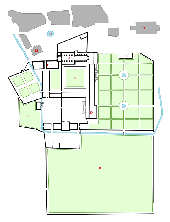
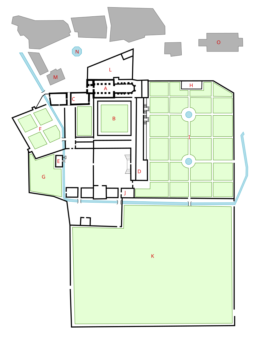
Français : Plan de l’abbaye de Munster (Haut-Rhin, France) et de son environnement immédiat dans son état de la fin du XVIIIe siècle. Le dessin est réalisé d’après le plan de 1805 Henri Lebert (archives du Haut-Rhin) en partie corrigé à partir de données plus récentes. Le plan Lebert étant néanmoins d’une précision relative, les proportions entre les bâtiments restent en partie inexacte, d’où l’absence d’échelle.
Légende : A : église abbatiale (auj. détruite) ; B : cloître (auj. partiellement détruit) ; C : palais abbatial, dit s’Bassial ; D : maison du prieur (auj. médiathèque intercommunale) ; E : moulin (auj. partiellement détruit) ; F : potager (auj. remplacé par un immeuble) ; G : verger (auj. remplacé par un immeuble) ; H : orangerie (auj. détruite) ; I : jardin (auj. remplacé par des immeubles et un parking) ; J : écuries (auj. détruites) ; K : pré (auj. remplacé par une usine) ; L : cimetière (auj. Place du Marché) ; M : halle au blé, dite Laub (déplacée par la suite) ; N : fontaine au lion (déplacée par la suite) ; O : église paroissiale Saint-Léger.English: Plan of the abbey of Munster (Haut-Rhin, France) and its surrounding at the end of the 18th century. The drawing has been made after a plan made by Henri Lebert in 1805 and partially corrected with more recent data. The proportion in the plan of Lebert are however too inaccurate to allow exact mapping of the area, hence some errors in scale and proportion may still be present.
Legend : A : Church of the abbey (destroyed) ; B : Cloister (partially destroyed) ; C : Palace, also known as s’Bassial ; D : House of the prior (now library) ; E : Watermill (partially destroyed) ; F : Vegetable garden (now constructed area) ; G : Orchard (now constructed area) ; H : Orangery (destroyed) ; I : Garden (now constructed area) ; J : Stables (destroyed) ; K : Meadow (now constructed area) ; L : Cemetery (now Marketplace) ; M : Covered market, also known as Laub (moved later) ; N : Lion’s fountain (moved later) ; O : Church St-Léger. |
| Date | |
| Source | Own work |
| Author | Runi Gerardsen |
| Permission (Reusing this file) |
Rúni Gerardsen / Plan de l’abbaye de Munster (Haut-Rhin, France) à la fin du XVIIIe siècle. / Wikimedia Commons / CC-BY-SA-4.0 |
Licensing
edit
- You are free:
- to share – to copy, distribute and transmit the work
- to remix – to adapt the work
- Under the following conditions:
- attribution – You must give appropriate credit, provide a link to the license, and indicate if changes were made. You may do so in any reasonable manner, but not in any way that suggests the licensor endorses you or your use.
- share alike – If you remix, transform, or build upon the material, you must distribute your contributions under the same or compatible license as the original.
File history
Click on a date/time to view the file as it appeared at that time.
| Date/Time | Thumbnail | Dimensions | User | Comment | |
|---|---|---|---|---|---|
| current | 16:22, 18 December 2022 | | 824 × 1,076 (58 KB) | Runi Gerardsen (talk | contribs) | Uploaded own work with UploadWizard |
You cannot overwrite this file.
File usage on Commons
There are no pages that use this file.
File usage on other wikis
The following other wikis use this file:
- Usage on fr.wikipedia.org