File:Plan de la ville, port, et rade de Newport, avec une partie de Rhode-Island occupée par l'armée française aux ordres de Mr. Le comte de Rochambeau, et de l'escadre française commandée. LOC gm71002157.jpg

Size of this preview: 632 × 600 pixels. Other resolutions: 253 × 240 pixels | 506 × 480 pixels | 809 × 768 pixels | 1,079 × 1,024 pixels | 2,158 × 2,048 pixels | 7,373 × 6,998 pixels.
Original file (7,373 × 6,998 pixels, file size: 7.13 MB, MIME type: image/jpeg)
Captions
Captions
Add a one-line explanation of what this file represents
Summary edit
| Description |
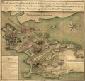
English: Scale ca. 1:26,200. Manuscript, pen-and-ink and watercolor. Has watermarks. Relief shown by form lines and shading. Shows fortifications, fields of fire, and positions of French naval vessels. Oriented with north toward the upper right. Includes index to defenses. LC Maps of North America, 1750-1789, 1018 Available also through the Library of Congress Web site as a raster image. Vault AACR2: 440; 651/1 |
||
| Title | Plan de la ville, port, et rade de Newport, avec une partie de Rhode-Island occupée par l'armée française aux ordres de Mr. Le comte de Rochambeau, et de l'escadre française commandée. | ||
| Shelf ID | G3774.N4S3 1780 .P51 | ||
| Date | |||
| Source | https://www.loc.gov/item/gm71002157/ | ||
| Author | Unknown author | ||
| Permission (Reusing this file) |
|
||
| Other versions |
|
||
| Location | United States · Rhode Island (Island) · Island · Newport · Rhode Island | ||
| Part of | France In America · Rochambeau Map Collection · Military Battles And Campaigns · Catalog · American Memory · Geography And Map Division · American Revolution And Its Era: Maps And Charts Of North America And The West Indies, 1750-1789 | ||
| Subject | Maps, Manuscript · Revolution · Rhode Island (Island) · Defenses · Rhode Island · Rhode Island (R.I. : Island) · Newport (R.I.) · Early Works To 1800 · Newport · United States · History |

Licensing edit
|
This is a faithful photographic reproduction of a two-dimensional, public domain work of art. The work of art itself is in the public domain for the following reason:
The official position taken by the Wikimedia Foundation is that "faithful reproductions of two-dimensional public domain works of art are public domain".
This photographic reproduction is therefore also considered to be in the public domain in the United States. In other jurisdictions, re-use of this content may be restricted; see Reuse of PD-Art photographs for details. | ||||
File history
Click on a date/time to view the file as it appeared at that time.
| Date/Time | Thumbnail | Dimensions | User | Comment | |
|---|---|---|---|---|---|
| current | 22:39, 12 June 2018 | | 7,373 × 6,998 (7.13 MB) | Fæ (talk | contribs) | LOC Maps https://www.loc.gov/item/gm71002157/ #13404 |
You cannot overwrite this file.
File usage on Commons
The following page uses this file: