File:Plan de routes importants du transport en commun au Grand Vancouver.svg

Size of this PNG preview of this SVG file: 512 × 246 pixels. Other resolutions: 320 × 154 pixels | 640 × 308 pixels | 1,024 × 492 pixels | 1,280 × 615 pixels | 2,560 × 1,230 pixels.
Original file (SVG file, nominally 512 × 246 pixels, file size: 1.54 MB)
Captions
Captions
Add a one-line explanation of what this file represents
Summary edit
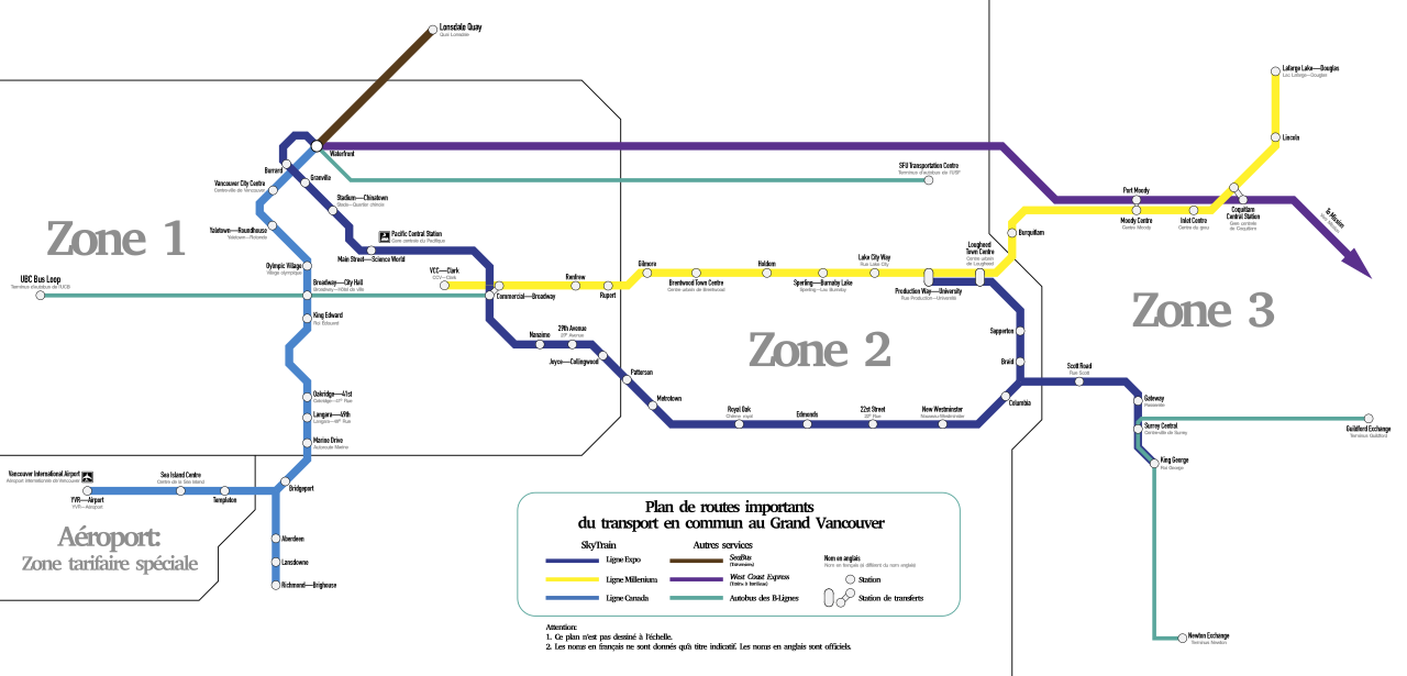
| Description |
Français : Version française de 2016年12月起大溫哥華主要公共交通路線圖.svg |
| Date | |
| Source | Own work |
| Author | Cedric tsan cantonais |
| SVG development | This W3C-invalid map was created with Adobe Illustrator. |

Licensing edit
I, the copyright holder of this work, hereby publish it under the following license:
This file is licensed under the Creative Commons Attribution-Share Alike 4.0 International license.
- You are free:
- to share – to copy, distribute and transmit the work
- to remix – to adapt the work
- Under the following conditions:
- attribution – You must give appropriate credit, provide a link to the license, and indicate if changes were made. You may do so in any reasonable manner, but not in any way that suggests the licensor endorses you or your use.
- share alike – If you remix, transform, or build upon the material, you must distribute your contributions under the same or compatible license as the original.
File history
Click on a date/time to view the file as it appeared at that time.
| Date/Time | Thumbnail | Dimensions | User | Comment | |
|---|---|---|---|---|---|
| current | 23:16, 11 December 2016 | | 512 × 246 (1.54 MB) | Cedric tsan cantonais (talk | contribs) | Ajouter B-Ligne 95. |
| 20:47, 25 November 2016 |  | 512 × 246 (1.33 MB) | Cedric tsan cantonais (talk | contribs) | User created page with UploadWizard |
You cannot overwrite this file.
File usage on Commons
The following 8 pages use this file:
- User:Chumwa/OgreBot/Potential transport maps/2016 December 11-20
- User:Chumwa/OgreBot/Potential transport maps/2016 November 21-30
- User:Chumwa/OgreBot/Public transport information/2016 December 11-20
- User:Chumwa/OgreBot/Public transport information/2016 November 21-30
- User:Chumwa/OgreBot/Transport Maps/2016 December 11-20
- User:Chumwa/OgreBot/Transport Maps/2016 November 21-30
- User:Chumwa/OgreBot/Travel and communication maps/2016 December 11-20
- User:Chumwa/OgreBot/Travel and communication maps/2016 November 21-30
File usage on other wikis
The following other wikis use this file:
- Usage on fr.wikipedia.org