File:Plan of South Boston Flats Showing Location of Sea Walls and Area of Excavations and Filling, 1876.jpg

Size of this preview: 469 × 599 pixels. Other resolutions: 188 × 240 pixels | 375 × 480 pixels | 601 × 768 pixels | 801 × 1,024 pixels | 1,565 × 2,000 pixels.
Original file (1,565 × 2,000 pixels, file size: 1.91 MB, MIME type: image/jpeg)
Captions
Captions
Add a one-line explanation of what this file represents
Summary
edit
| Description |
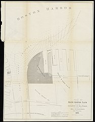
English: Plan of South Boston Flats Showing Location of Sea Walls and Area of Excavations and Filling, 1876. "The soundings are reduced to mean low water and show the depths of water in feet." Shows the course of Fort Point Channel and surrounding docks in South Boston. In House Doc. No. 25, 1877, and Public Doc. No. 33, 1877. Eleventh Annual Report of the Board of Harbor Commissioners. |
| Date | |
| Source | Digital Commons, Salem State |
| Author | Board of Harbor and Land Commissioners of Massachusetts |
Licensing
edit
This work is in the public domain in the United States because it was published (or registered with the U.S. Copyright Office) before January 1, 1929.
Public domain works must be out of copyright in both the United States and in the source country of the work in order to be hosted on the Commons. If the work is not a U.S. work, the file must have an additional copyright tag indicating the copyright status in the source country.
Note: This tag should not be used for sound recordings. |
File history
Click on a date/time to view the file as it appeared at that time.
| Date/Time | Thumbnail | Dimensions | User | Comment | |
|---|---|---|---|---|---|
| current | 16:59, 3 September 2021 | | 1,565 × 2,000 (1.91 MB) | Daderot (talk | contribs) | Uploaded a work by Massachusetts Commission on Harbors and Flats from Digital Commons, Salem State with UploadWizard |
You cannot overwrite this file.
File usage on Commons
There are no pages that use this file.