File:Plan view of Nirgal Vallis ESA20823973.jpeg
Size of this preview: 800 × 372 pixels. Other resolutions: 320 × 149 pixels | 640 × 298 pixels | 1,024 × 477 pixels | 1,280 × 596 pixels | 2,560 × 1,192 pixels | 7,733 × 3,600 pixels.
Original file (7,733 × 3,600 pixels, file size: 10.36 MB, MIME type: image/jpeg)
Captions
Captions
Add a one-line explanation of what this file represents
Summary
edit| Description |
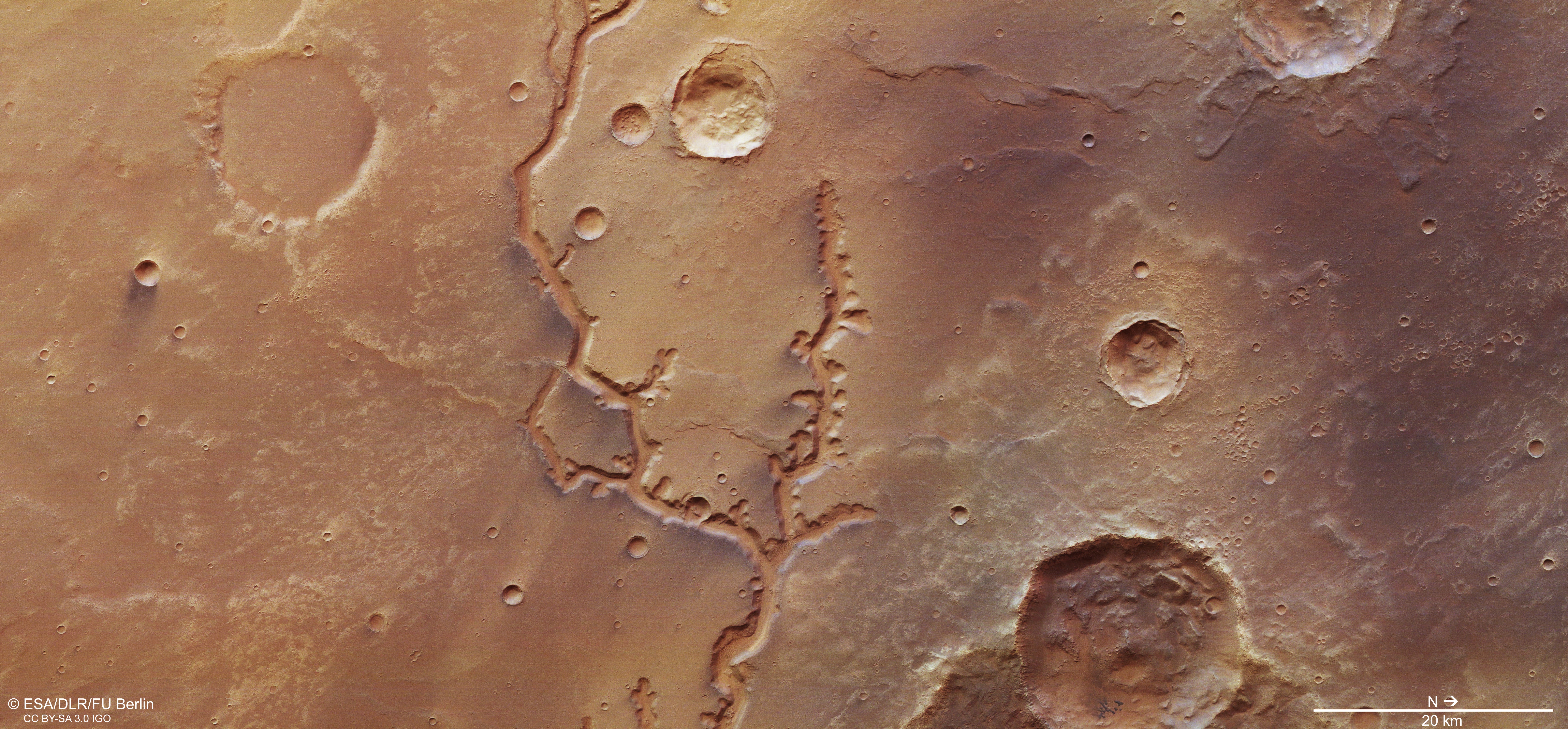
English: This image from ESA’s Mars Express shows a dried-up river valley on Mars named Nirgal Vallis. It comprises data gathered on 16 November 2018 during Mars Express Orbit 18818. The ground resolution is approximately 14 m/pixel and the images are centred at about 315°E/27°S. This image was created using data from the nadir and colour channels of the High Resolution Stereo Camera. The nadir channel is aligned perpendicular to the surface of Mars, as if looking straight down at the surface. North is to the right. |
| Date | 10 October 2019 (upload date) |
| Source | Plan view of Nirgal Vallis |
| Author | ESA/DLR/FU Berlin |
| Other versions |
|
| Activity | Space Science |
| Mission | Mars Express |

Licensing
edit
This media was created by the European Space Agency (ESA).
Where expressly so stated, images or videos are covered by the Creative Commons Attribution-ShareAlike 3.0 IGO (CC BY-SA 3.0 IGO) licence, ESA being an Intergovernmental Organisation (IGO), as defined by the CC BY-SA 3.0 IGO licence. The user is allowed under the terms and conditions of the CC BY-SA 3.0 IGO license to Reproduce, Distribute and Publicly Perform the ESA images and videos released under CC BY-SA 3.0 IGO licence and the Adaptations thereof, without further explicit permission being necessary, for as long as the user complies with the conditions and restrictions set forth in the CC BY-SA 3.0 IGO licence, these including that:
See the ESA Creative Commons copyright notice for complete information, and this article for additional details.
|
 | |
This file is licensed under the Creative Commons Attribution-ShareAlike 3.0 IGO license. Attribution: ESA/DLR/FU Berlin, CC BY-SA IGO 3.0
| ||
File history
Click on a date/time to view the file as it appeared at that time.
| Date/Time | Thumbnail | Dimensions | User | Comment | |
|---|---|---|---|---|---|
| current | 13:06, 7 June 2020 | | 7,733 × 3,600 (10.36 MB) | OptimusPrimeBot (talk | contribs) | #Spacemedia - Upload of https://www.esa.int/var/esa/storage/images/esa_multimedia/images/2019/10/plan_view_of_nirgal_vallis/20823962-1-eng-GB/Plan_view_of_Nirgal_Vallis.jpg via Commons:Spacemedia |
You cannot overwrite this file.
File usage on Commons
The following 3 pages use this file:
.jpg&redirect=no)
File usage on other wikis
The following other wikis use this file:
- Usage on de.wikipedia.org