File:Plano de la ensenada de Lastres situado por observación el cavo del mismo nombre en la latitud N. de 43⁰28ʹ20ʺ LOC 90683769.tif
Size of this JPG preview of this TIF file: 760 × 599 pixels. Other resolutions: 305 × 240 pixels | 609 × 480 pixels | 974 × 768 pixels | 1,280 × 1,009 pixels | 2,560 × 2,019 pixels | 9,635 × 7,597 pixels.
Original file (9,635 × 7,597 pixels, file size: 209.42 MB, MIME type: image/tiff)
Captions
Captions
Add a one-line explanation of what this file represents
Summary edit
| Description |
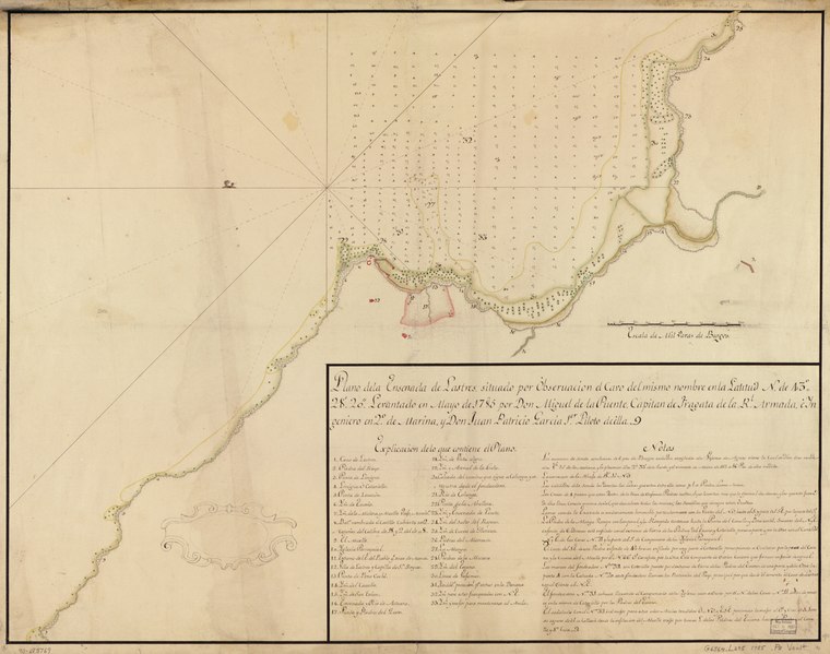
English: Depths shown by soundings. Oriented with north to the left. Pen-and-ink and watercolor. Mounted on cloth backing. LC Luso-Hispanic World, 794 Available also through the Library of Congress Web site as a raster image. Includes index and text. Maggs number annotated in pencil in lower right margin: 90. Vault |
||
| Title | Plano de la ensenada de Lastres situado por observación el cavo del mismo nombre en la latitud N. de 43⁰28ʹ20ʺ | ||
| Shelf ID | G6564.L295 1785 .P8 | ||
| Date | |||
| Source | https://www.loc.gov/item/90683769/ | ||
| Author | Puente, Miguel De La.; García, Juan Patricio | ||
| Permission (Reusing this file) |
|
||
| Other versions |
|
||
| Location | Atlantic Coast · Lastres · Spain | ||
| Part of | American Memory · Catalog · Geography And Map Division · Cultural Landscapes | ||
| Subject | Maps, Manuscript · Coasts · Lastres (Spain) · Lastres · Atlantic Coast (Spain) · Maps · Early Works To 1800 · Manuscript Maps · Atlantic Coast · Spain |


Licensing edit
|
This is a faithful photographic reproduction of a two-dimensional, public domain work of art. The work of art itself is in the public domain for the following reason:
The official position taken by the Wikimedia Foundation is that "faithful reproductions of two-dimensional public domain works of art are public domain".
This photographic reproduction is therefore also considered to be in the public domain in the United States. In other jurisdictions, re-use of this content may be restricted; see Reuse of PD-Art photographs for details. | ||||
File history
Click on a date/time to view the file as it appeared at that time.
| Date/Time | Thumbnail | Dimensions | User | Comment | |
|---|---|---|---|---|---|
| current | 17:28, 22 May 2018 |  | 9,635 × 7,597 (209.42 MB) | Fæ (talk | contribs) | LOC Maps https://www.loc.gov/item/90683769/ #13370 |
You cannot overwrite this file.
File usage on Commons
The following page uses this file: