File:Plaque commemorating George Goyder's line of rainfall, South Australia.jpg

Size of this preview: 800 × 523 pixels. Other resolutions: 320 × 209 pixels | 640 × 418 pixels | 1,024 × 669 pixels | 1,280 × 836 pixels | 1,861 × 1,216 pixels.
Original file (1,861 × 1,216 pixels, file size: 2.63 MB, MIME type: image/jpeg)
Captions
Captions
Plaque commemorating George Goyder's line of rainfall, South Australia
Summary edit
| Description |
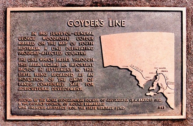
English: Plaque commemorating George Goyder's line of rainfall, South Australia, beyond which he considered rainfall to be generally too variable to support agriculture. Goyder, who was the state's surveyor-general, determined the boundary referring to documents in his office followed by observation of vegetation during a horse-mounted expedition for the purpose in 1865. His judgement was scorned when a few years of abundant rains occurred, but eventually proved to have been realistic. |
| Date | 10 April 2018 |
| Source | Own work |
| Author | SCHolar44 |
| Camera location | | View this and other nearby images on: OpenStreetMap |
|---|
Licensing edit
I, the copyright holder of this work, hereby publish it under the following license:
| This file is made available under the Creative Commons CC0 1.0 Universal Public Domain Dedication. | |
| The person who associated a work with this deed has dedicated the work to the public domain by waiving all of their rights to the work worldwide under copyright law, including all related and neighboring rights, to the extent allowed by law. You can copy, modify, distribute and perform the work, even for commercial purposes, all without asking permission.
|
File history
Click on a date/time to view the file as it appeared at that time.
| Date/Time | Thumbnail | Dimensions | User | Comment | |
|---|---|---|---|---|---|
| current | 10:06, 26 April 2022 | | 1,861 × 1,216 (2.63 MB) | SCHolar44 (talk | contribs) | Uploaded own work with UploadWizard |
You cannot overwrite this file.
File usage on Commons
There are no pages that use this file.
File usage on other wikis
The following other wikis use this file:
- Usage on en.wikipedia.org