File:Poland administrative divisions (1998-07-17 project).svg

Size of this PNG preview of this SVG file: 644 × 600 pixels. Other resolutions: 258 × 240 pixels | 516 × 480 pixels | 825 × 768 pixels | 1,100 × 1,024 pixels | 2,200 × 2,048 pixels | 1,000 × 931 pixels.
Original file (SVG file, nominally 1,000 × 931 pixels, file size: 1.68 MB)
Captions
Captions
Add a one-line explanation of what this file represents
Summary
edit.svg&action=edit§ion=1)
| Description |
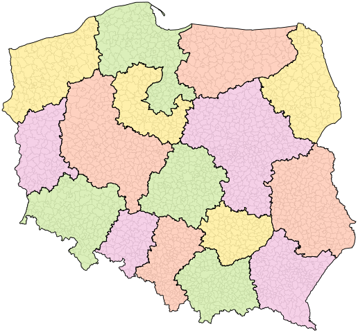
English: Map of Polish voivodeships according to the PM project of 16 July 1998 with Sejm commission amendments of 17 July.
Legend: gray lines – commune borders, black borders – voivodeship borders. Polski: Mapa województw według poselskiego projektu z 16 lipca 1998 z poprawkami komisji sejmowych z 17 lipca. Legenda: szare linie – granice gmin, czarne linie – granice województw. |
| Date | |
| Source |
Poselski projekt ustawy o wprowadzeniu zasadniczego trójstopniowego podziału terytorialnego państwa (druk nr 513 z dn. 1998-07-16) Sprawozdanie Komisji Samorządu Terytorialnego i Polityki Regionalnej oraz Komisji Administracji i Spraw Wewnętrznych o poselskim projekcie ustawy o wprowadzeniu zasadniczego trójstopniowego podziału terytorialnego państwa (druk nr 513) (druk nr 519 z dn. 1998-07-17) |
| Author | TexLacerta |
Licensing
edit.svg&action=edit§ion=2)
I, the copyright holder of this work, hereby publish it under the following license:
This file is licensed under the Creative Commons Attribution 4.0 International license.
- You are free:
- to share – to copy, distribute and transmit the work
- to remix – to adapt the work
- Under the following conditions:
- attribution – You must give appropriate credit, provide a link to the license, and indicate if changes were made. You may do so in any reasonable manner, but not in any way that suggests the licensor endorses you or your use.
File history
Click on a date/time to view the file as it appeared at that time.
| Date/Time | Thumbnail | Dimensions | User | Comment | |
|---|---|---|---|---|---|
| current | 12:45, 14 January 2024 | | 1,000 × 931 (1.68 MB) | TexLacerta (talk | contribs) | == {{int:filedesc}} == {{Information |description={{en|1=Map of Polish voivodeships according to the PM project of 16 July 1998 with Sejm commission amendments of 17 July.<br/>Legend: gray lines – commune borders, black borders – voivodeship borders.}} {{pl|1=Mapa województw według poselskiego projektu z 16 lipca 1998 z poprawkami komisji sejmowych z 17 lipca.<br/>Legenda: szare linie – granice gmin, czarne linie – granice województw.}} |date=2024-01-14 |source=[https://orka.sejm.gov.pl/Rejes... |
You cannot overwrite this file.
File usage on Commons
There are no pages that use this file.
File usage on other wikis
The following other wikis use this file:
- Usage on pl.wikipedia.org
.svg&oldid=841512249)