File:Poland county map (1993-08 project).svg

Size of this PNG preview of this SVG file: 645 × 600 pixels. Other resolutions: 258 × 240 pixels | 516 × 480 pixels | 826 × 768 pixels | 1,101 × 1,024 pixels | 2,202 × 2,048 pixels | 1,000 × 930 pixels.
Original file (SVG file, nominally 1,000 × 930 pixels, file size: 2.32 MB)
Captions
Captions
Add a one-line explanation of what this file represents
Summary
edit.svg&action=edit§ion=1)
| Description |
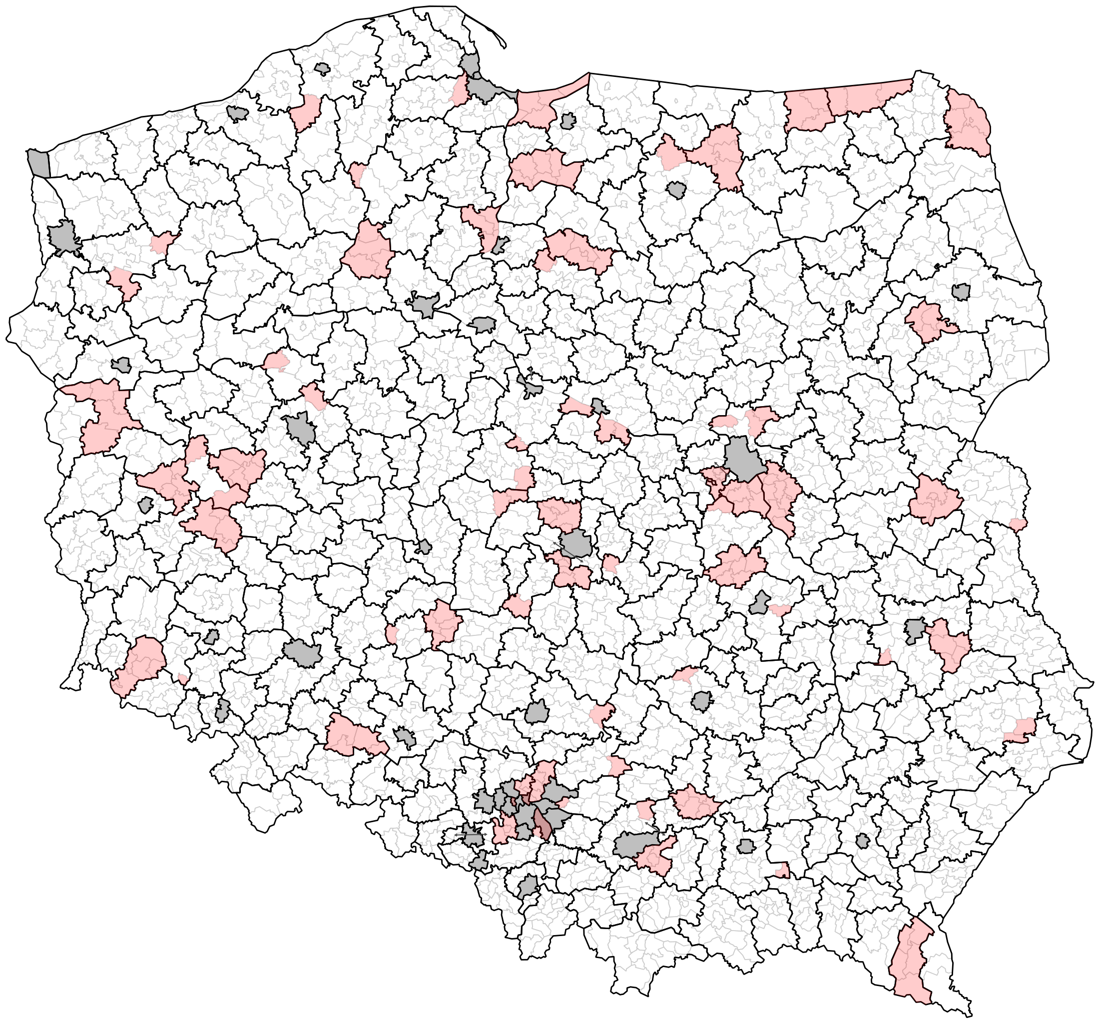
English: Map of Polish counties according to the government project of August 1993.
Legend: gray lines – commune borders, black borders – county borders, gray background – cities with county rights, pink background – county border changes in comparison to borders of May 1993 project. Polski: Mapa powiatów według rządowego projektu z sierpnia 1993 roku. Legenda: szare linie – granice gmin, czarne linie – granice powiatów, szare tło – miasta na prawach powiatów, różowe tło – obszary powiatów zmienione w stosunku do projektowanego podziału na powiaty z maja 1993 roku. |
| Date | |
| Source | Proponowane siedziby i zasięgi powiatów : projekt podziału terytorialnego kraju na powiaty. „Wspólnota”. 37 (183), s. 7–15, 1993-09-11. Warszawa: Wydawnictwo „Przemiany”. ISSN 0867-0935. |
| Author | TexLacerta |
Licensing
edit.svg&action=edit§ion=2)
I, the copyright holder of this work, hereby publish it under the following license:
This file is licensed under the Creative Commons Attribution 4.0 International license.
- You are free:
- to share – to copy, distribute and transmit the work
- to remix – to adapt the work
- Under the following conditions:
- attribution – You must give appropriate credit, provide a link to the license, and indicate if changes were made. You may do so in any reasonable manner, but not in any way that suggests the licensor endorses you or your use.
File history
Click on a date/time to view the file as it appeared at that time.
| Date/Time | Thumbnail | Dimensions | User | Comment | |
|---|---|---|---|---|---|
| current | 15:27, 19 October 2023 | | 1,000 × 930 (2.32 MB) | TexLacerta (talk | contribs) | added county changes, added margin |
| 20:44, 12 October 2023 |  | 1,000 × 930 (2.22 MB) | TexLacerta (talk | contribs) | {{Information |description={{en|1=Map of Polish counties according to the government project of August 1993.<br/>Legend: gray lines – commune borders, black borders – county borders, gray background – cities with county rights.}} {{pl|1=Mapa powiatów według rządowego projektu z sierpnia 1993 roku.<br/>Legenda: szare linie – granice gmin, czarne linie – granice powiatów, szare tło – miasta na prawach powiatów.}} |date=2023-10-12 |source=''Proponowane siedziby i zasięgi powiatów : projekt podzi... |
You cannot overwrite this file.
File usage on Commons
There are no pages that use this file.
File usage on other wikis
The following other wikis use this file:
- Usage on pl.wikipedia.org
.svg&oldid=813087672)