File:Polhemsrad-Infotafel.jpg

Size of this preview: 450 × 600 pixels. Other resolutions: 180 × 240 pixels | 360 × 480 pixels | 576 × 768 pixels | 768 × 1,024 pixels | 1,500 × 2,000 pixels.
Original file (1,500 × 2,000 pixels, file size: 572 KB, MIME type: image/jpeg)
Captions
Captions
Add a one-line explanation of what this file represents
| Description |
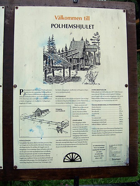
Deutsch: Das Polhemsrad (Polhemshjulet) ist ein Wasserrad, das in der schwedischen Bergwerksregion Bergslagen (nahe Norberg) von 1876 bis 1920 Teil eines Antriebsystems zur Entwässerung von Erzgruben war. Foto: Infotafel |
||
| Date | |||
| Source | Self-photographed | ||
| Author | Jürgen Howaldt | ||
| Permission (Reusing this file) |
|
| Camera location | | View this and other nearby images on: OpenStreetMap |
|---|
File history
Click on a date/time to view the file as it appeared at that time.
| Date/Time | Thumbnail | Dimensions | User | Comment | |
|---|---|---|---|---|---|
| current | 15:14, 23 May 2008 | | 1,500 × 2,000 (572 KB) | Godewind (talk | contribs) | {{Information| |Description={{de|Das Polhemsrad (Polhemshjulet) ist ein Wasserrad, das in der schwedischen Bergwerksregion Bergslagen (nahe Norberg) von 1876 bis 1920 Teil eines Antriebsystems zur Entwässerung von Erzgruben war. Foto: Infotafel}} |Source |
You cannot overwrite this file.
File usage on Commons
There are no pages that use this file.
File usage on other wikis
The following other wikis use this file:
- Usage on de.wikipedia.org