File:Polish-Lithuanian Commonwealth ru (1619).PNG
Size of this preview: 760 × 599 pixels. Other resolutions: 304 × 240 pixels | 609 × 480 pixels | 974 × 768 pixels | 1,280 × 1,009 pixels | 1,973 × 1,556 pixels.
Original file (1,973 × 1,556 pixels, file size: 132 KB, MIME type: image/png)
Captions
Captions
Add a one-line explanation of what this file represents
| Description |
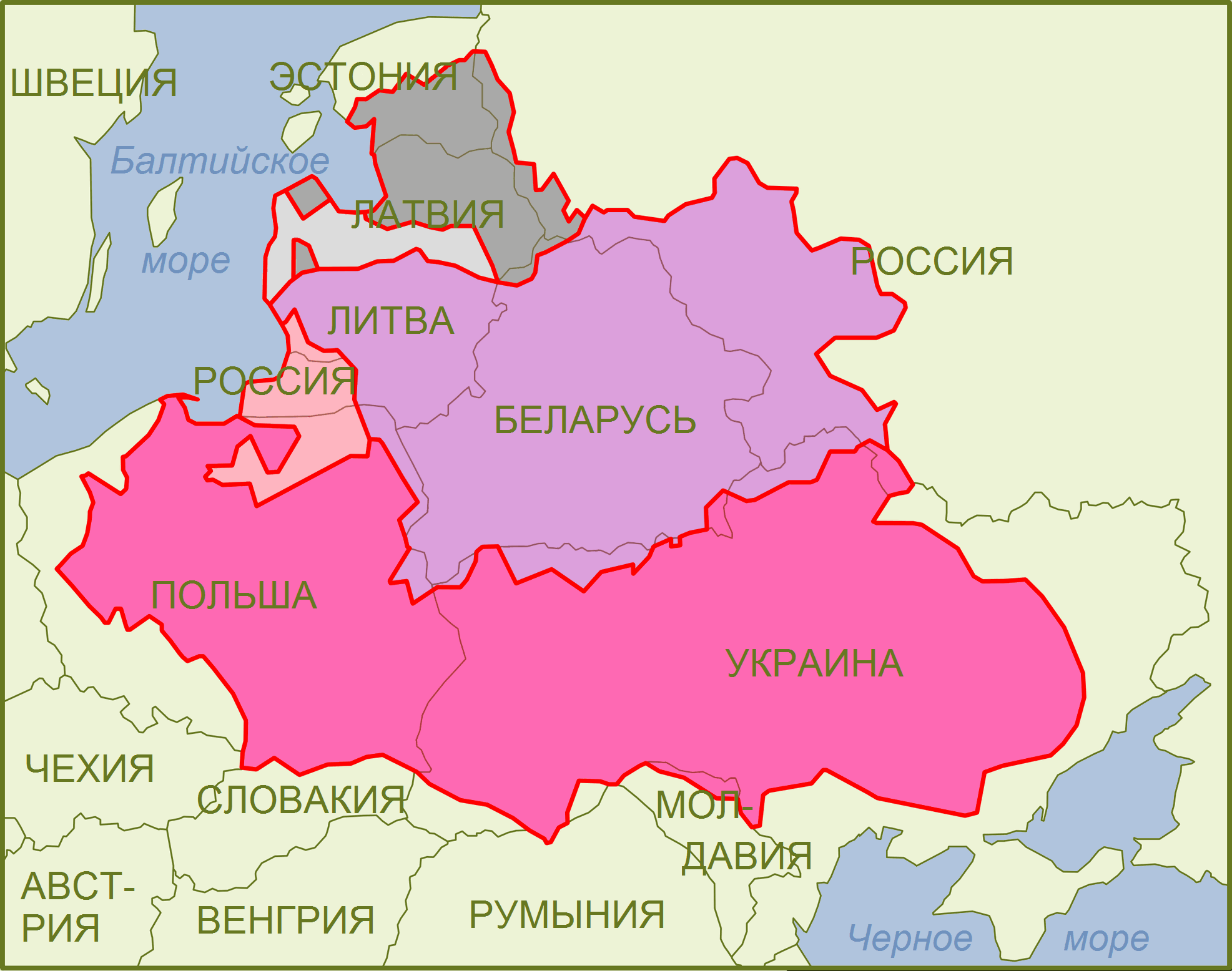
English: Polish-Lithuanian Commonwealth (1619) compared with today's borders Legend Русский: Карта Речи Посполитой после Деулинского перемирия, совмещённая с картой границ современных государствЛегенда
Герцогство Пруссия, вассал Королевства Польского
Герцогство Курляндия и Семигалия, вассал ВКЛ, с 1569 - Речи Посполитой
Задвинское герцогство, кондоминиум ВКЛ и Польши |
| Date | (UTC) |
| Source | |
| Author |
|
.png)
| This is a retouched picture, which means that it has been digitally altered from its original version. Modifications: Russian version. The original can be viewed here: Polish-Lithuanian Commonwealth (1619).png:
|
I, the copyright holder of this work, hereby publish it under the following licenses:
This file is licensed under the Creative Commons Attribution-Share Alike 2.5 Generic, 2.0 Generic and 1.0 Generic license.
- You are free:
- to share – to copy, distribute and transmit the work
- to remix – to adapt the work
- Under the following conditions:
- attribution – You must give appropriate credit, provide a link to the license, and indicate if changes were made. You may do so in any reasonable manner, but not in any way that suggests the licensor endorses you or your use.
- share alike – If you remix, transform, or build upon the material, you must distribute your contributions under the same or compatible license as the original.
| This file is licensed under the Creative Commons Attribution-Share Alike 3.0 Unported license. | ||
| ||
| This licensing tag was added to this file as part of the GFDL licensing update. |

|
Permission is granted to copy, distribute and/or modify this document under the terms of the GNU Free Documentation License, Version 1.2 or any later version published by the Free Software Foundation; with no Invariant Sections, no Front-Cover Texts, and no Back-Cover Texts. A copy of the license is included in the section entitled GNU Free Documentation License. |
You may select the license of your choice.
Original upload log
edit.PNG&action=edit§ion=1)
This image is a derivative work of the following images:
- File:Polish-Lithuanian_Commonwealth_(1619).png licensed with Cc-by-sa-2.5,2.0,1.0, Cc-by-sa-3.0-migrated, GFDL
- 2010-05-25T13:42:30Z Ras67 1957x1539 (569673 Bytes) cropped
- 2007-04-15T18:31:34Z Lexicon 1973x1556 (633997 Bytes) Version with colours made more distinct (and web-friendly, matching perfectly named we colours). Use legend provided.
- 2007-02-03T15:20:10Z Der Eberswalder 803x630 (50361 Bytes) small error in Baltic Sea corrected
- 2007-02-03T15:16:28Z Der Eberswalder 803x630 (50407 Bytes) Swedish Estonia, Baltic and Black Seas colored
- 2007-02-01T14:55:22Z Der Eberswalder 803x630 (51455 Bytes)
Uploaded with derivativeFX
File history
Click on a date/time to view the file as it appeared at that time.
| Date/Time | Thumbnail | Dimensions | User | Comment | |
|---|---|---|---|---|---|
| current | 12:40, 17 January 2012 | | 1,973 × 1,556 (132 KB) | Bogomolov.PL (talk | contribs) | larger non-bold font, Belarus name changed from 'Белоруссия' to 'Беларусь' |
| 22:30, 12 January 2012 |  | 1,973 × 1,556 (128 KB) | Bogomolov.PL (talk | contribs) | удалены шведские владения в эстонии как не имеющие отношгения к тематике карты, заново сделаны подписи (стали более заметные), подписано Аз | |
| 12:01, 24 August 2010 |  | 1,957 × 1,539 (497 KB) | Zair Probus (talk | contribs) | {{Information |Description={{en|1=Polish-Lithuanian Commonwealth (1619) compared with today's borders <u>'''Legend'''</u> {{legend|hotpink|Kingdom of Poland}} {{legend|lightpink|Duchy of Prussia, Polish fief}} {{legend|plum|Grand Duchy of Lithuania}} {{l |
You cannot overwrite this file.
File usage on Commons
There are no pages that use this file.
File usage on other wikis
The following other wikis use this file:
- Usage on ru.wikipedia.org
.PNG&oldid=622004134)