File:Polska 1333 - 1370 (it).png
Size of this preview: 630 × 599 pixels. Other resolutions: 252 × 240 pixels | 505 × 480 pixels | 808 × 768 pixels | 1,077 × 1,024 pixels | 2,153 × 2,048 pixels | 2,636 × 2,507 pixels.
Original file (2,636 × 2,507 pixels, file size: 1.99 MB, MIME type: image/png)
Captions
Captions
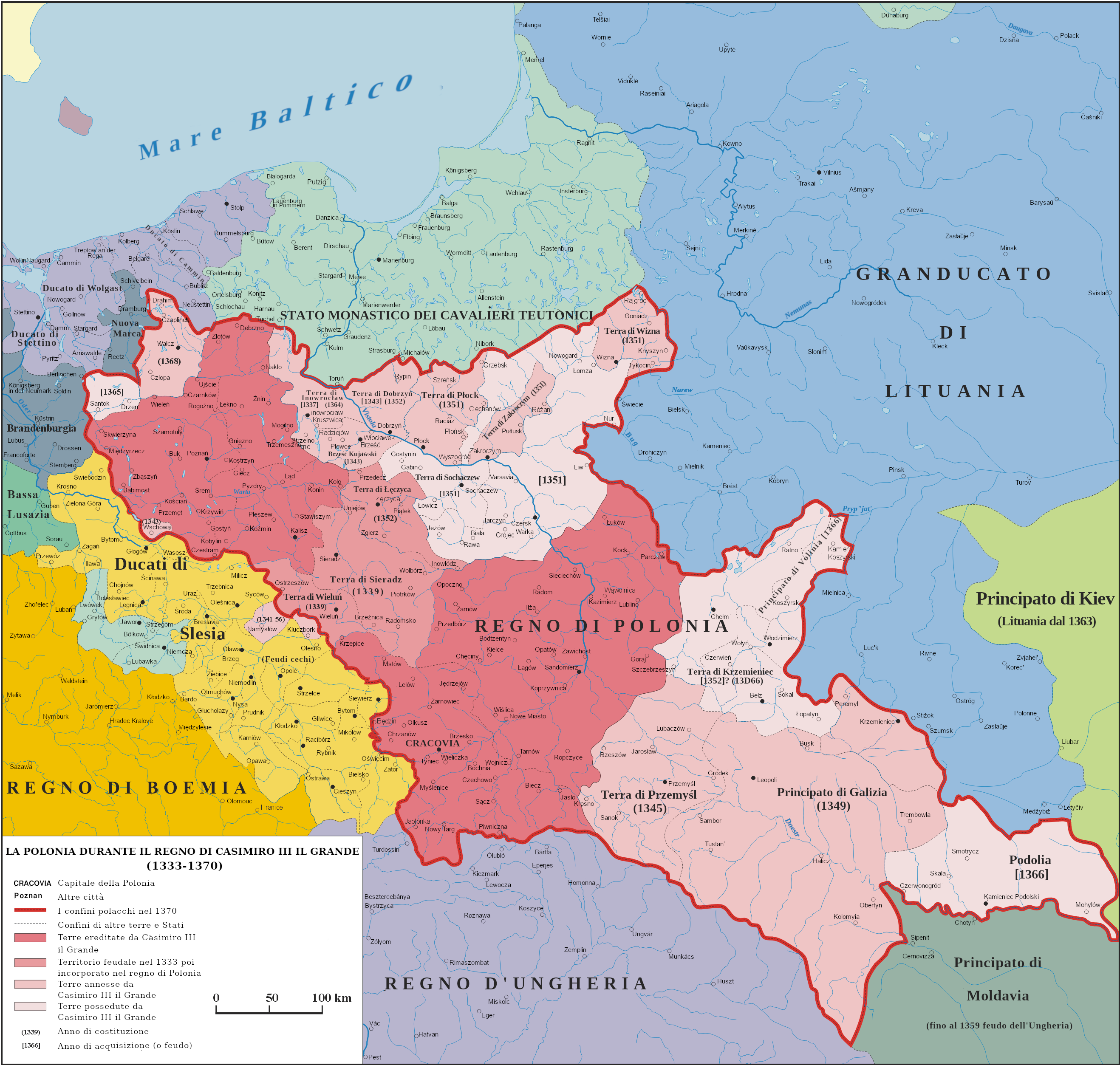
Map of Poland and territorial borders during the reign of Casimir III the Great (1333 - 1370)
Summary edit
.png&action=edit§ion=1)
| Description |
English: Map of Poland and territorial borders during the reign of Casimir III the Great (1333 - 1370)
Italiano: Mappa della Polonia e dei territori di confine durante il regno di Casimiro III il Grande (1333 - 1370) |
| Date | |
| Source | Own work na podstawie "Ilustrowany atlas historii Polski, wyd. Demart, Warszawa 2006" |
| Author | Poznaniak (traslate by Adert) |
| Permission (Reusing this file) |
I, the copyright holder of this work, hereby publish it under the following license: This file is licensed under the Creative Commons Attribution-Share Alike 3.0 Unported license.
|
| Other versions |
 |
Licensing edit
.png&action=edit§ion=2)
I, the copyright holder of this work, hereby publish it under the following license:
This file is licensed under the Creative Commons Attribution-Share Alike 3.0 Unported license.
- You are free:
- to share – to copy, distribute and transmit the work
- to remix – to adapt the work
- Under the following conditions:
- attribution – You must give appropriate credit, provide a link to the license, and indicate if changes were made. You may do so in any reasonable manner, but not in any way that suggests the licensor endorses you or your use.
- share alike – If you remix, transform, or build upon the material, you must distribute your contributions under the same or compatible license as the original.

|
This historical map image could be re-created using vector graphics as an SVG file. This has several advantages; see Commons:Media for cleanup for more information. If an SVG form of this image is available, please upload it and afterwards replace this template with
{{vector version available|new image name}}.
It is recommended to name the SVG file “Polska 1333 - 1370 (it).svg”—then the template Vector version available (or Vva) does not need the new image name parameter. |
File history
Click on a date/time to view the file as it appeared at that time.
| Date/Time | Thumbnail | Dimensions | User | Comment | |
|---|---|---|---|---|---|
| current | 09:23, 26 January 2024 | | 2,636 × 2,507 (1.99 MB) | Adert (talk | contribs) | Fix error |
| 08:59, 4 November 2023 |  | 2,636 × 2,507 (1.99 MB) | Adert (talk | contribs) | Uploaded own work with UploadWizard |
You cannot overwrite this file.
File usage on Commons
The following page uses this file:
File usage on other wikis
The following other wikis use this file:
- Usage on fr.wikipedia.org
- Usage on it.wikipedia.org
- Usage on mn.wikipedia.org
- Usage on pt.wikipedia.org
.png&oldid=845595794)