File:Pont sur l'Orb, Roquebrun 02.jpg
Size of this preview: 800 × 534 pixels. Other resolutions: 320 × 214 pixels | 640 × 427 pixels | 1,024 × 683 pixels | 1,280 × 854 pixels | 2,560 × 1,708 pixels | 7,244 × 4,834 pixels.
Original file (7,244 × 4,834 pixels, file size: 24.2 MB, MIME type: image/jpeg)
Captions
Captions
Add a one-line explanation of what this file represents
Summary edit
| Description |
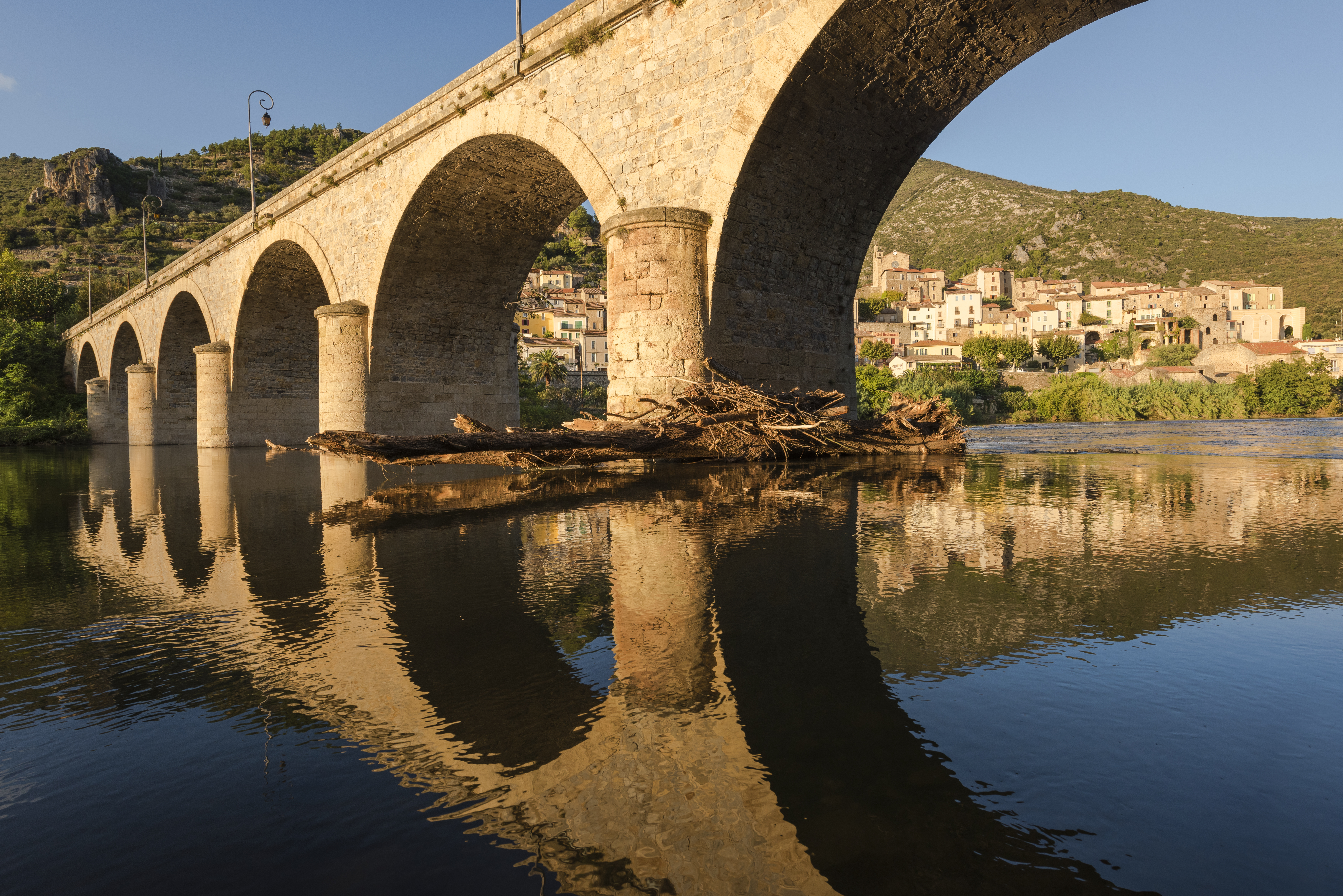
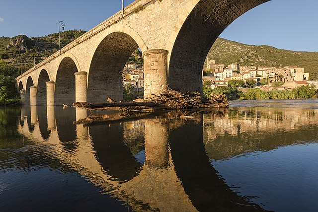
Français : Le pont sur l'Orb, pont en arc à 7 arches datant de 1870. Et dans le fond une partie du village de Roquebrun, Hérault, France. Parc naturel régional du Haut-Languedoc. English: The Bridge above the Orb River, arch bridge of 7 archs dated from 1870. And in the background a part of the village of Roquebrun, Hérault, France. Haut-Languedoc Regional Natural Park.
Português: Ponte de sete arcos sobre o rio Orb datada de 1870. Ao fundo vê-se parte da comuna francesa de Roquebrun, em Hérault.
Bosanski: Most iznad rijeke Orb i selo Roquebrun, Hérault, Francuska, regionalni prirodni park Haut-Languedoc.
Čeština: Most přes řeku Orb a vesnice Roquebrun, departement Hérault, Francie. Přírodní park Haut-Languedoc Regional Natural Park.
Español: El puente sobre el río Orb y el pueblo de Roquebrun, Hérault, Francia. Parque Natural Regional del Alto Languedoc.
Magyar: Híd az Orb folyó felett, Roquebrun településnél (Haut-Languedoc Regionális Természetvédelmi Park, Hérault, Franciaország)
|
| Date | Taken on 2 October 2014, 18:41:32 |
| Source | Own work |
| Author | Christian Ferrer |
| Permission (Reusing this file) |
I, the copyright holder of this work, hereby publish it under the following license: This file is licensed under the Creative Commons Attribution 4.0 International license.
|
| Camera location | | View this and other nearby images on: OpenStreetMap |
|---|
|
This image was selected as picture of the day on Wikimedia Commons for 2 June 2015. It was captioned as follows: English: The Bridge above the Orb River and the village of Roquebrun, Hérault, France. Haut-Languedoc Regional Natural Park. Other languages:
Bosanski: Most iznad rijeke Orb i selo Roquebrun, Hérault, Francuska, regionalni prirodni park Haut-Languedoc. Čeština: Most přes řeku Orb a vesnice Roquebrun, departement Hérault, Francie. Přírodní park Haut-Languedoc Regional Natural Park. English: The Bridge above the Orb River and the village of Roquebrun, Hérault, France. Haut-Languedoc Regional Natural Park. Español: El puente sobre el río Orb y el pueblo de Roquebrun, Hérault, Francia. Parque Natural Regional del Alto Languedoc. Français : Le pont sur l’Orb et le village de Roquebrun, Hérault, France. Parc naturel régional du Haut-Languedoc. Magyar: Híd az Orb folyó felett, Roquebrun településnél (Haut-Languedoc Regionális Természetvédelmi Park, Hérault, Franciaország) Português: Ponte de sete arcos sobre o rio Orb datada de 1870. Ao fundo vê-se parte da comuna francesa de Roquebrun, em Hérault. |
File history
Click on a date/time to view the file as it appeared at that time.
| Date/Time | Thumbnail | Dimensions | User | Comment | |
|---|---|---|---|---|---|
| current | 17:15, 7 November 2014 | | 7,244 × 4,834 (24.2 MB) | Christian Ferrer (talk | contribs) | color |
| 16:59, 7 November 2014 |  | 7,244 × 4,834 (23.04 MB) | Christian Ferrer (talk | contribs) | User created page with UploadWizard |
You cannot overwrite this file.
File usage on Commons
The following 31 pages use this file:
- User:Jon Harald Søby/Liz
- User:Miya/POTY/2014
- User:Pechristener/Bridges/2014 November 1-10
- User talk:Christian Ferrer/Archive10
- Commons:Featured picture candidates/File:Pont sur l'Orb, Roquebrun 02.jpg
- Commons:Featured picture candidates/Log/November 2014
- Commons:Featured pictures/Places/Architecture/Bridges
- Commons:Featured pictures/chronological/2014-B
- Commons:Picture of the Year/2014/Candidates
- Commons:Picture of the Year/2014/R1/Gallery/2014-B
- Commons:Picture of the Year/2014/R1/Gallery/ALL
- Commons:Picture of the Year/2014/R1/Gallery/Infrastructure
- Commons:Picture of the Year/2014/R1/Gallery/M11
- Commons:Picture of the Year/2014/R1/Results/Candidates
- Commons:Picture of the Year/2014/R1/Results/Candidates/Infrastructure
- Commons:Picture of the Year/2014/R1/Results/Infrastructure
- Commons:Picture of the Year/2014/R1/v/Pont sur l'Orb, Roquebrun 02.jpg
- Commons:Quality images/Subject/Architecture/Transport Infrastructure/Bridges/Archive
- Commons:Quality images candidates/Archives November 13 2014
- Template:Potd/2015-06
- Template:Potd/2015-06-02
- Template:Potd/2015-06-02 (bs)
- Template:Potd/2015-06-02 (cs)
- Template:Potd/2015-06-02 (en)
- Template:Potd/2015-06-02 (es)
- Template:Potd/2015-06-02 (fr)
- Template:Potd/2015-06-02 (hu)
- Template:Potd/2015-06-02 (it)
- Template:Potd/2015-06-02 (ko)
- Template:Potd/2015-06-02 (nl)
- Template:Potd/2015-06-02 (pt)
File usage on other wikis
The following other wikis use this file:
- Usage on be-tarask.wikipedia.org
- Usage on bn.wikipedia.org
- Usage on crh.wikipedia.org
- Usage on cv.wikipedia.org
- Usage on de.wikivoyage.org
- Usage on de.wiktionary.org
- Usage on en.wikipedia.org
- Usage on hu.wikipedia.org
- Usage on it.wikipedia.org
- Usage on it.wiktionary.org
- Usage on ka.wikipedia.org
- Usage on ko.wikipedia.org
- Usage on krc.wikipedia.org
- Usage on lbe.wikipedia.org
- Usage on ms.wikipedia.org
- Usage on os.wikipedia.org
- Usage on pt.wikipedia.org
- Usage on ru.wikipedia.org
- Usage on ru.wikinews.org
- Usage on sah.wikipedia.org
- Usage on tt.wikipedia.org
- Usage on uk.wikipedia.org
- Usage on xal.wikipedia.org
- Usage on zh.wikipedia.org