File:Powiat łowicki location map.png
Original file (1,399 × 1,456 pixels, file size: 711 KB, MIME type: image/png)
Captions
Captions
Summary edit
| Description |
English: Location map |
| Date | |
| Source | Own work |
| Author | Smat |
| Description |
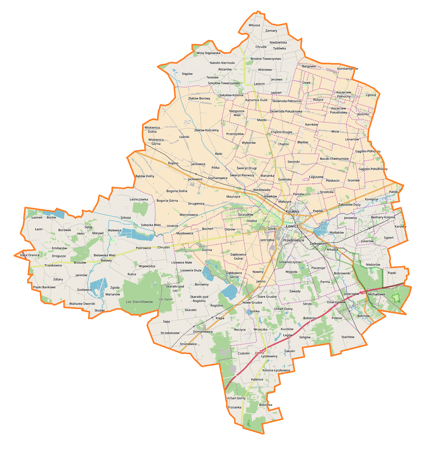
Polski: Mapa powiatu łowickiego, Polska
English: Map of powiat łowicki, Poland |
|||||||||
| Date | ||||||||||
| Source | You may find a page on the OpenStreetMap wiki page for powiat łowicki | |||||||||
| Creator |
OpenStreetMap contributors OpenStreetMap contributors |
|||||||||
| Permission (Reusing this file) |
OpenStreetMap data is available under the Open Database License (details). Map tiles are licensed under the Creative Commons Attribution-ShareAlike 2.0 license (CC-BY-SA 2.0).
This file is licensed under the Creative Commons Attribution-Share Alike 2.0 Generic license.
|
|||||||||
| Geotemporal data | ||||||||||
| Bounding box |
|
|||||||||
| Georeferencing | If inappropriate please set warp_status = skip to hide. | |||||||||
Licensing edit
| This work contains information from OpenStreetMap, which is made available under the Open Database License (ODbL).
The ODbL does not require any particular license for maps produced from ODbL data. Prior to 1 August 2020, map tiles produced by the OpenStreetMap Foundation were licensed under the CC-BY-SA-2.0 license. Maps produced by other people may be subject to other licences. |
File history
Click on a date/time to view the file as it appeared at that time.
| Date/Time | Thumbnail | Dimensions | User | Comment | |
|---|---|---|---|---|---|
| current | 15:53, 3 November 2017 | | 1,399 × 1,456 (711 KB) | Smat (talk | contribs) | User created page with UploadWizard |
You cannot overwrite this file.
File usage on Commons
There are no pages that use this file.
File usage on other wikis
The following other wikis use this file:
- Usage on eo.wikipedia.org
- Usage on pl.wikipedia.org
- Łowicz
- Arkadia (powiat łowicki)
- Sanktuarium Matki Bożej Domaniewickiej Pocieszycielki Strapionych
- Domaniewice (województwo łódzkie)
- Nieborów (województwo łódzkie)
- Bednary (województwo łódzkie)
- Kiernozia
- Bednary-Kolonia
- Bełchów
- Bielawska Wieś
- Bobiecko
- Bocheń
- Bąków Dolny
- Bąków Górny
- Bogoria Dolna
- Bogoria Górna
- Bogoria Pofolwarczna
- Brodne-Józefów
- Brodne-Towarzystwo
- Bogumin (województwo łódzkie)
- Chruśle
- Chruślin
- Chąśno
- Chąśno Drugie
- Chyleniec
- Czatolin
- Czerniew
- Drogusza
- Dąbkowice Dolne
- Dąbkowice Górne
- Gągolin Południowy
- Gągolin Północny
- Gągolin Zachodni
- Goleńsko
- Guźnia
- Gzinka
- Helin
- Jackowice
- Jadzień
- Jerzewo (województwo łódzkie)
- Klewków
- Kalenice
- Karsznice Duże
- Karsznice Małe
- Kocierzew Południowy
- Kocierzew Północny
- Kolonia Łyszkowice
- Kompina
- Lenartów
View more global usage of this file.