File:Powiat lubański location map (cropped).png
Powiat_lubański_location_map_(cropped).png (783 × 478 pixels, file size: 237 KB, MIME type: image/png)
Captions
Captions
Summary
edit| Description |
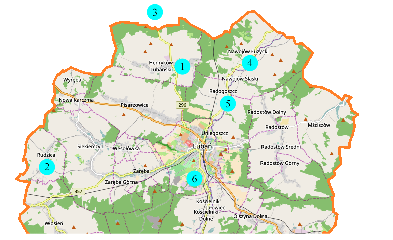
English: Location map with former properties of Lauban Abbey of the Order of St Mary Magdalene (1-Katholisch Hennersdorf now Henryków Lubański; 2-Pfaffendorf now Rudzica; 3-Günthersdorf now Godzieszów; 4-Sächsisch Haugsdorf now Nawojów Łużycki; 5-Wünschendorf now Radogoszcz; 6-Kerzdorf now Księginki and part of Lubań) |
| Date | |
| Source | Own work |
| Author | Smat |
| Other versions |

.png&action=edit§ion=1)
| Description |
Polski: Mapa powiatu lubańskiego, Polska
English: Map of powiat lubański, Poland |
|||||||||
| Date | ||||||||||
| Source | You may find a page on the OpenStreetMap wiki page for powiat lubański | |||||||||
| Creator |
OpenStreetMap contributors OpenStreetMap contributors |
|||||||||
| Permission (Reusing this file) |
OpenStreetMap data is available under the Open Database License (details). Map tiles are licensed under the Creative Commons Attribution-ShareAlike 2.0 license (CC-BY-SA 2.0).
This file is licensed under the Creative Commons Attribution-Share Alike 2.0 Generic license.
|
|||||||||
| Geotemporal data | ||||||||||
| Bounding box |
|
|||||||||
| Georeferencing | If inappropriate please set warp_status = skip to hide. | |||||||||
Licensing
edit.png&action=edit§ion=2)
| This work contains information from OpenStreetMap, which is made available under the Open Database License (ODbL).
The ODbL does not require any particular license for maps produced from ODbL data. Prior to 1 August 2020, map tiles produced by the OpenStreetMap Foundation were licensed under the CC-BY-SA-2.0 license. Maps produced by other people may be subject to other licences. |
File history
Click on a date/time to view the file as it appeared at that time.
| Date/Time | Thumbnail | Dimensions | User | Comment | |
|---|---|---|---|---|---|
| current | 10:23, 2 February 2020 | | 783 × 478 (237 KB) | PaulT (talk | contribs) | Klosterorte der Magdalenerinnen markiert |
| 10:21, 2 February 2020 |  | 772 × 466 (221 KB) | PaulT (talk | contribs) | File:Powiat lubański location map.png cropped 2 % horizontally, 59 % vertically using CropTool with precise mode. |
You cannot overwrite this file.
File usage on Commons
The following page uses this file:
File usage on other wikis
The following other wikis use this file:
- Usage on de.wikipedia.org
.png&oldid=728920671)