File:Prague-East District 2007 names PH CZ.png
Size of this preview: 596 × 600 pixels. Other resolutions: 238 × 240 pixels | 477 × 480 pixels | 954 × 960 pixels.
Original file (954 × 960 pixels, file size: 169 KB, MIME type: image/png)
Captions
Captions
Add a one-line explanation of what this file represents
Summary
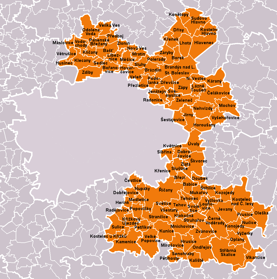
edit| Description |
Čeština: Obce okresu Praha-východ dle stavu k 1. lednu 2007 (110 obcí). Bílé linie o různé tloušťce představují hranice obcí, správních obvodů, okresů a krajů.
English: Municipalities of Prague-East District as of January 1, 2007 (110 municipalities in total). White lines of variable thickness show boundaries of municipalities, administrative areas, districts and regions. |
| Date | |
| Source | Own work based on File:Prague-East_District_2007_PH_CZ.png |
| Author | User:Miaow Miaow |
| Permission (Reusing this file) |
PD-self |
| Other versions |
|


Licensing
edit
| I, the copyright holder of this work, release this work into the public domain. This applies worldwide. In some countries this may not be legally possible; if so: I grant anyone the right to use this work for any purpose, without any conditions, unless such conditions are required by law. |
File history
Click on a date/time to view the file as it appeared at that time.
| Date/Time | Thumbnail | Dimensions | User | Comment | |
|---|---|---|---|---|---|
| current | 20:03, 5 May 2010 | | 954 × 960 (169 KB) | Miaow Miaow (talk | contribs) | {{Information |Description={{cs|Obce '''okresu Praha-východ''' dle stavu k 1. lednu 2007 (110 obcí). Bílé linie o různé tloušťce představují hranice obcí, správních obvodů, okresů a krajů.}} {{en|Municipalities |
You cannot overwrite this file.
File usage on Commons
More than 100 pages use this file. The following list shows the first 100 pages that use this file only. A full list is available.
- File:Babice PH CZ.png
- File:Bast PH CZ.png
- File:Boranovice PH CZ.png
- File:Borek PH CZ.png
- File:Brandys nad Labem-Stara Boleslav PH CZ.png
- File:Brazdim PH CZ.png
- File:Brezi PH CZ.png
- File:Celakovice PH CZ.png
- File:Cerne Voderady PH CZ.png
- File:Cestlice PH CZ.png
- File:Dobrejovice PH CZ.png
- File:Dobrocovice PH CZ.png
- File:Doubek PH CZ.png
- File:Drevcice PH CZ.png
- File:Drisy PH CZ.png
- File:Herink PH CZ.png
- File:Hlavenec PH CZ.png
- File:Horousany PH CZ.png
- File:Hovorcovice PH CZ.png
- File:Hrusice PH CZ.png
- File:Husinec PH CZ.png
- File:Jenstejn PH CZ.png
- File:Jevany PH CZ.png
- File:Jirny PH CZ.png
- File:Kaliste PH CZ.png
- File:Kamenice PH CZ.png
- File:Karany PH CZ.png
- File:Klecany PH CZ.png
- File:Klicany PH CZ.png
- File:Klokocna PH CZ.png
- File:Konetopy PH CZ.png
- File:Konojedy PH CZ.png
- File:Kostelec nad Cernymi lesy PH CZ.png
- File:Kostelec u Krizku PH CZ.png
- File:Kostelni Hlavno PH CZ.png
- File:Kozojedy PH CZ.png
- File:Krenek PH CZ.png
- File:Krenice PH CZ.png
- File:Krizkovy Ujezdec PH CZ.png
- File:Kunice PH CZ.png
- File:Kvetnice PH CZ.png
- File:Lazne Tousen PH CZ.png
- File:Lhota PH CZ.png
- File:Libeznice PH CZ.png
- File:Lounovice PH CZ.png
- File:Maslovice PH CZ.png
- File:Mesice PH CZ.png
- File:Mirosovice PH CZ.png
- File:Mnichovice PH CZ.png
- File:Mochov PH CZ.png
- File:Modletice PH CZ.png
- File:Mratin PH CZ.png
- File:Mukarov PH CZ.png
- File:Nehvizdy PH CZ.png
- File:Nova Ves PH CZ.png
- File:Novy Vestec PH CZ.png
- File:Nucice PH CZ.png
- File:Nupaky PH CZ.png
- File:ORP Brandys nad Labem-Stara Boleslav PH CZ.png
- File:ORP Ricany PH CZ.png
- File:Odolena Voda PH CZ.png
- File:Oleska PH CZ.png
- File:Ondrejov PH CZ.png
- File:Oplany PH CZ.png
- File:Panenske Brezany PH CZ.png
- File:Petihosty PH CZ.png
- File:Petrikov PH CZ.png
- File:Podolanka PH CZ.png
- File:Polerady PH CZ.png
- File:Popovicky PH CZ.png
- File:Prague-East District 2007 ORP PH CZ.png
- File:Prague-East District 2007 PH CZ.png
- File:Predboj PH CZ.png
- File:Prezletice PH CZ.png
- File:Prusice PH CZ.png
- File:Radejovice PH CZ.png
- File:Radonice PH CZ.png
- File:Ricany PH CZ.png
- File:Sedlec PH CZ.png
- File:Senohraby PH CZ.png
- File:Sestajovice PH CZ.png
- File:Sibrina PH CZ.png
- File:Skvorec PH CZ.png
- File:Sluhy PH CZ.png
- File:Slustice PH CZ.png
- File:Stihlice PH CZ.png
- File:Strancice PH CZ.png
- File:Stribrna Skalice PH CZ.png
- File:Struharov PH CZ.png
- File:Sudovo Hlavno PH CZ.png
- File:Sulice PH CZ.png
- File:Svemyslice PH CZ.png
- File:Svetice PH CZ.png
- File:Svojetice PH CZ.png
- File:Tehov PH CZ.png
- File:Tehovec PH CZ.png
- File:Uvaly PH CZ.png
- File:Velika Ves PH CZ.png
- File:Velke Popovice PH CZ.png
- File:Vodochody PH CZ.png
View more links to this file.
File usage on other wikis
The following other wikis use this file:
- Usage on azb.wikipedia.org
- Usage on bg.wikipedia.org
- Usage on ceb.wikipedia.org
- Usage on cs.wikipedia.org
- Usage on de.wikipedia.org
- Usage on en.wikipedia.org
- Usage on eo.wikipedia.org
- Usage on es.wikipedia.org
- Usage on fa.wikipedia.org
- Usage on frr.wikipedia.org
- Usage on hu.wikipedia.org
- Usage on it.wikipedia.org
- Usage on ka.wikipedia.org
- Usage on ko.wikipedia.org
- Usage on ms.wikipedia.org
- Usage on nl.wikipedia.org
- Usage on pl.wikipedia.org
- Usage on pnb.wikipedia.org
- Usage on ru.wikipedia.org
- Usage on sk.wikipedia.org
- Usage on sv.wikipedia.org
- Usage on uk.wikipedia.org
- Usage on war.wikipedia.org
- Usage on xmf.wikipedia.org
- Usage on zh.wikipedia.org