File:Predicative map of Mt.Fuji volcanic-ash-fall.jpg
No higher resolution available.
Predicative_map_of_Mt.Fuji_volcanic-ash-fall.jpg (720 × 550 pixels, file size: 363 KB, MIME type: image/jpeg)
Captions
Captions
Add a one-line explanation of what this file represents
Summary edit
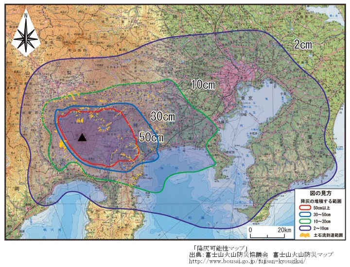
| Description | 富士山降灰可能性図(The predicative map of the volcanic-ash-fall of Mt.Fuji) | ||
| Date | 富士山ハザードマップ検討委員会報告書 平成16年6月 (released 2004-6- ) | ||
| Source |
出典:富士山火山防災マップ (The volcanic hazard mad of Mt.Fuji; [1]) by 富士山防災協議会(the Mt.Fuji Volcano Disaster Management Conference; http://www.bousai.go.jp//fujisan-kyougikai/) |
||
| Author |
富士山防災協議会 (the Mt.Fuji Volcano Disaster Management Conference); Miya.m added the URL and the information to the Map and uploaded under the permission of the Cabinet Office of the Japanese Government |
||
| Permission (Reusing this file) |
This file is licensed under the Creative Commons Attribution 4.0 International license. Attribution: 内閣府防災のページ
|
||
| Other versions | Image:Hazard Map of Mt.Fuji common l.jpg |

![[1]](http://www.bousai.go.jp/fujisan-kyougikai/fuji_map/common_l.jpg)
Licensing edit
work of "the Mt.Fuji Volcano Disaster Management Conference" (http://www.bousai.go.jp/fujisan-kyougikai/ archive copy at the Wayback Machine) supported by Japanese government cabinet officials (http://www.bousai.go.jp/); confirmed to be CC-by-4.0
This file is licensed under the Creative Commons Attribution 4.0 International license.
- You are free:
- to share – to copy, distribute and transmit the work
- to remix – to adapt the work
- Under the following conditions:
- attribution – You must give appropriate credit, provide a link to the license, and indicate if changes were made. You may do so in any reasonable manner, but not in any way that suggests the licensor endorses you or your use.
File history
Click on a date/time to view the file as it appeared at that time.
| Date/Time | Thumbnail | Dimensions | User | Comment | |
|---|---|---|---|---|---|
| current | 06:19, 26 March 2006 | | 720 × 550 (363 KB) | Miya.m (talk | contribs) | {{Information| |Description = 富士山降灰可能性図(The predicative map of the volcanic-ash-fall of Mt.Fuji |Source =出典:富士山火山防災マップ (The volcanic hazard mad of Mt.Fuji; http://www.bousai.go.jp/fujisan-kyougikai/fuji_map/ |
You cannot overwrite this file.
File usage on Commons
There are no pages that use this file.
File usage on other wikis
The following other wikis use this file:
- Usage on it.wikibooks.org
- Usage on ja.wikipedia.org