File:Provincetown before after railroad.png

Original file (2,230 × 2,460 pixels, file size: 9.88 MB, MIME type: image/png)
Captions
Captions
| Description |
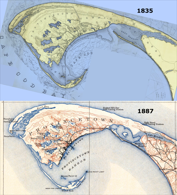
Town of Provincetown, before and after the railroad. Most notably, there were no roads in/out of town until the US government artificially sealed off the Eastern Harbor. This was done so as to prevent storm washout from breaching the northernmost part of that harbor; a breach would have made Provincetown an island permanently, and would have destroyed the valuable harbor. This later provided the foundation for the railroad to finally come to Provincetown in 1873, and for a formal road in 1877. Top (1835) map extracted from "A Map Of The Extremity Of Cape Cod Including the Townships of Provincetown & Truro: A Chart Of Their Sea Coast And Of Cape Cod Harbour, State of Massachusetts", by the U.S. Topographical Engineers (later were rolled into the US Army Corps of Engineers. Grolltech: Colorized and reoriented with north to top of page. Bottom (1887) map extracted from "Massachusetts, Provincetown Sheet", by the US Geological Survey. See individual file pages for more details about the original works. |
|||||||||
| Date | (top) and 1887 (bottom) | |||||||||
| Source | United States Topographical Bureau (top), US Geological Survey (bottom) | |||||||||
| Author |
Top: Graham, Maj. James D., Hood, Washington, U.S. Topo. Engrs., United States Topographical Bureau Bottom: Henry Gannett and Marcus Baker, US Geological Survey (USGS) |
|||||||||
| Permission (Reusing this file) |
|
|||||||||
| Other versions | ||||||||||


File history
Click on a date/time to view the file as it appeared at that time.
| Date/Time | Thumbnail | Dimensions | User | Comment | |
|---|---|---|---|---|---|
| current | 22:52, 7 June 2012 | | 2,230 × 2,460 (9.88 MB) | Grolltech (talk | contribs) | {{Information |Description=Town of Provincetown, before and after the railroad. Most notably, there were no roads in/out of town until the US government artificially sealed off the Eastern Harbor. This was done so as to prevent storm washout from brea... |
You cannot overwrite this file.
File usage on Commons
The following 3 pages use this file:
File usage on other wikis
The following other wikis use this file:
- Usage on en.wikipedia.org
- Usage on ja.wikipedia.org
- Usage on vi.wikipedia.org
- Usage on www.wikidata.org