File:Provincies-Gemeenten-public-600.png
Size of this preview: 471 × 599 pixels. Other resolutions: 189 × 240 pixels | 600 × 763 pixels.
Original file (600 × 763 pixels, file size: 200 KB, MIME type: image/png)
Captions
Captions
Add a one-line explanation of what this file represents
Summary
edit
| Description |
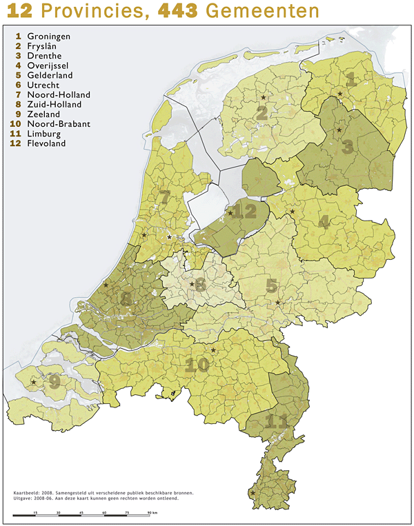
Nederlands: 12 provincies en 443 gemeenten. Situatie 2008. |
| Date |
17 May 2008 (original upload date) |
| Source |
(Original text : Jan-Willem van Aalst, samengesteld uit publiek beschikbare geo-data:
|
| Author | Jan-Willem van Aalst |
| Permission (Reusing this file) |
CC NL 2.5 |
Licensing
edit
Janwillemvanaalst at Dutch Wikipedia, the copyright holder of this work, hereby publishes it under the following license:
This file is licensed under the Creative Commons Attribution 2.5 Netherlands license.
Attribution: Janwillemvanaalst at Dutch Wikipedia
- You are free:
- to share – to copy, distribute and transmit the work
- to remix – to adapt the work
- Under the following conditions:
- attribution – You must give appropriate credit, provide a link to the license, and indicate if changes were made. You may do so in any reasonable manner, but not in any way that suggests the licensor endorses you or your use.

Original upload log
edit
Transferred from nl.wikipedia to Commons by GijsvdL using CommonsHelper.
The original description page was here. All following user names refer to nl.wikipedia.
- 2008-05-17 18:37 Janwillemvanaalst 600×763×8 (204488 bytes) {{Information |Description=12 provincies en 443 gemeenten. Situatie 2008. |Source=Jan-Willem van Aalst, samengesteld uit publiek beschikbare geo-data. |Date=17 mei 2008. |Author=Jan-Willem van Aalst |Permission=CC NL 2.5 |other_versions= }} <!-- VERPLICHT
File history
Click on a date/time to view the file as it appeared at that time.
| Date/Time | Thumbnail | Dimensions | User | Comment | |
|---|---|---|---|---|---|
| current | 21:51, 28 May 2008 | | 600 × 763 (200 KB) | File Upload Bot (Magnus Manske) (talk | contribs) | {{BotMoveToCommons|nl.wikipedia}} {{Information |Description={{nl|12 provincies en 443 gemeenten. Situatie 2008.}} |Source=Transferred from [http://nl.wikipedia.org nl.wikipedia]; transfered to Commons by User:GijsvdL using [http://tools.wikimedia.de |
You cannot overwrite this file.
File usage on Commons
There are no pages that use this file.