File:Prowincje I RP-variante de.svg

Size of this PNG preview of this SVG file: 689 × 600 pixels. Other resolutions: 276 × 240 pixels | 552 × 480 pixels | 883 × 768 pixels | 1,177 × 1,024 pixels | 2,354 × 2,048 pixels | 855 × 744 pixels.
Original file (SVG file, nominally 855 × 744 pixels, file size: 345 KB)
Captions
Captions
Add a one-line explanation of what this file represents
Summary
edit
| Description |
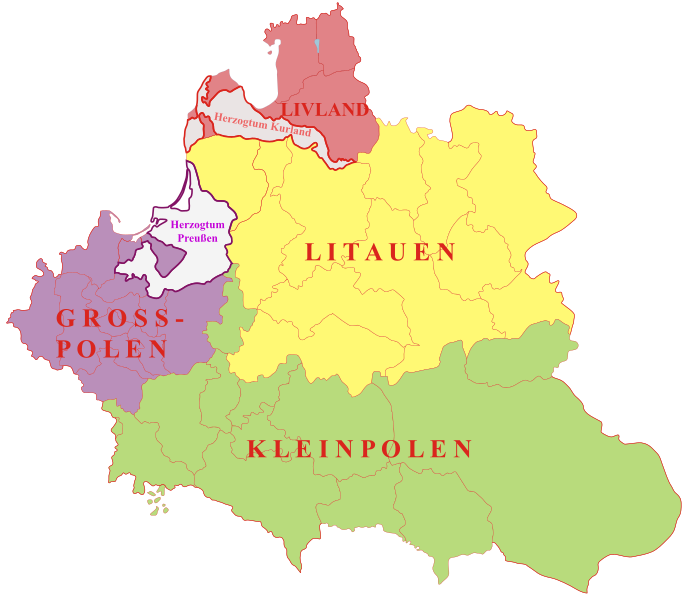
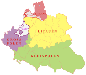
Deutsch: Großräumige Verwaltungseinteilung des polnisch-litauischen Staates Anfang des 17. Jahrhunderts.
Polski: Prowincje I Rzeczypospolitej |
| Date | (UTC) |
| Source |
This file was derived from: Prowincje I RP.svg: |
| Author |
|
| This is a retouched picture, which means that it has been digitally altered from its original version. Modifications: deutsche Übersetzung, vereinfachte Farbgebung. The original can be viewed here: Prowincje I RP.svg:
|
Licensing
edit
I, the copyright holder of this work, hereby publish it under the following licenses:
This file is licensed under the Creative Commons Attribution-Share Alike 2.5 Generic, 2.0 Generic and 1.0 Generic license.
- You are free:
- to share – to copy, distribute and transmit the work
- to remix – to adapt the work
- Under the following conditions:
- attribution – You must give appropriate credit, provide a link to the license, and indicate if changes were made. You may do so in any reasonable manner, but not in any way that suggests the licensor endorses you or your use.
- share alike – If you remix, transform, or build upon the material, you must distribute your contributions under the same or compatible license as the original.
| This file is licensed under the Creative Commons Attribution-Share Alike 3.0 Unported license. | ||
| ||
| This licensing tag was added to this file as part of the GFDL licensing update. |

|
Permission is granted to copy, distribute and/or modify this document under the terms of the GNU Free Documentation License, Version 1.2 or any later version published by the Free Software Foundation; with no Invariant Sections, no Front-Cover Texts, and no Back-Cover Texts. A copy of the license is included in the section entitled GNU Free Documentation License. |
You may select the license of your choice.
Original upload log
edit
This image is a derivative work of the following images:
- File:Prowincje_I_RP.svg licensed with Cc-by-sa-2.5,2.0,1.0, Cc-by-sa-3.0-migrated, GFDL
- 2006-12-21T10:24:50Z Poznaniak 1047x916 (195491 Bytes) {{Information |Description=Prowincje I Rzeczypospolitej |Source=własna praca |Date=21.12.2006 |Author=[[user:Poznaniak|Poznaniak]] |Permission={{self2|GFDL|cc-by-sa-2.5,2.0,1.0}} }} [[Category:Maps of the history of Poland]
Uploaded with derivativeFX
File history
Click on a date/time to view the file as it appeared at that time.
| Date/Time | Thumbnail | Dimensions | User | Comment | |
|---|---|---|---|---|---|
| current | 12:43, 25 March 2012 | | 855 × 744 (345 KB) | Furfur (talk | contribs) | == {{int:filedesc}} == {{Information |Description={{de|1=Großräumige Verwaltungseinteilung des polnisch-litauischen Staates Anfang des 17. Jahrhunderts.}} {{pl|1=Prowincje I Rzeczypospolitej}} |Source={{Derived from|Prowincje_I_RP.svg|display=50}} |D... |
You cannot overwrite this file.
File usage on Commons
There are no pages that use this file.
File usage on other wikis
The following other wikis use this file:
- Usage on de.wikipedia.org
- Usage on de.wiktionary.org
- Usage on hu.wikipedia.org