File:Pteryx UAV - Ortophoto 4.5km2.jpg

Size of this preview: 675 × 600 pixels. Other resolutions: 270 × 240 pixels | 540 × 480 pixels | 864 × 768 pixels | 1,152 × 1,024 pixels.
Original file (1,152 × 1,024 pixels, file size: 522 KB, MIME type: image/jpeg)
Captions
Captions
Add a one-line explanation of what this file represents
Summary edit
| Description |
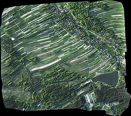
English: An example of ortophotomap assembled from 750 photos taken during a flight of small UAV. 4.5km2 surface, 11.1cm/pixel resolution, 300m flight altitude, 1h flight duration. Note high contrast compared to full scale airplane aerial imaginery. |
| Date | |
| Source | Own work |
| Author | Kbosak |
Licensing edit
I, the copyright holder of this work, hereby publish it under the following license:
This file is licensed under the Creative Commons Attribution 3.0 Unported license.
- You are free:
- to share – to copy, distribute and transmit the work
- to remix – to adapt the work
- Under the following conditions:
- attribution – You must give appropriate credit, provide a link to the license, and indicate if changes were made. You may do so in any reasonable manner, but not in any way that suggests the licensor endorses you or your use.
File history
Click on a date/time to view the file as it appeared at that time.
| Date/Time | Thumbnail | Dimensions | User | Comment | |
|---|---|---|---|---|---|
| current | 01:53, 13 October 2011 | | 1,152 × 1,024 (522 KB) | Kbosak (talk | contribs) | {{Information |Description ={{en|1=An example of ortophotomap assembled from 750 photos taken during a flight of small UAV. 4.5km2 surface, 11.1cm/pixel resolution, 300m flight altitude, 1h flight duration. Note high contrast compared to full scale air |
You cannot overwrite this file.
File usage on Commons
There are no pages that use this file.
File usage on other wikis
The following other wikis use this file:
- Usage on en.wikipedia.org