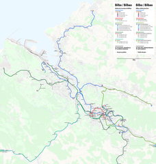
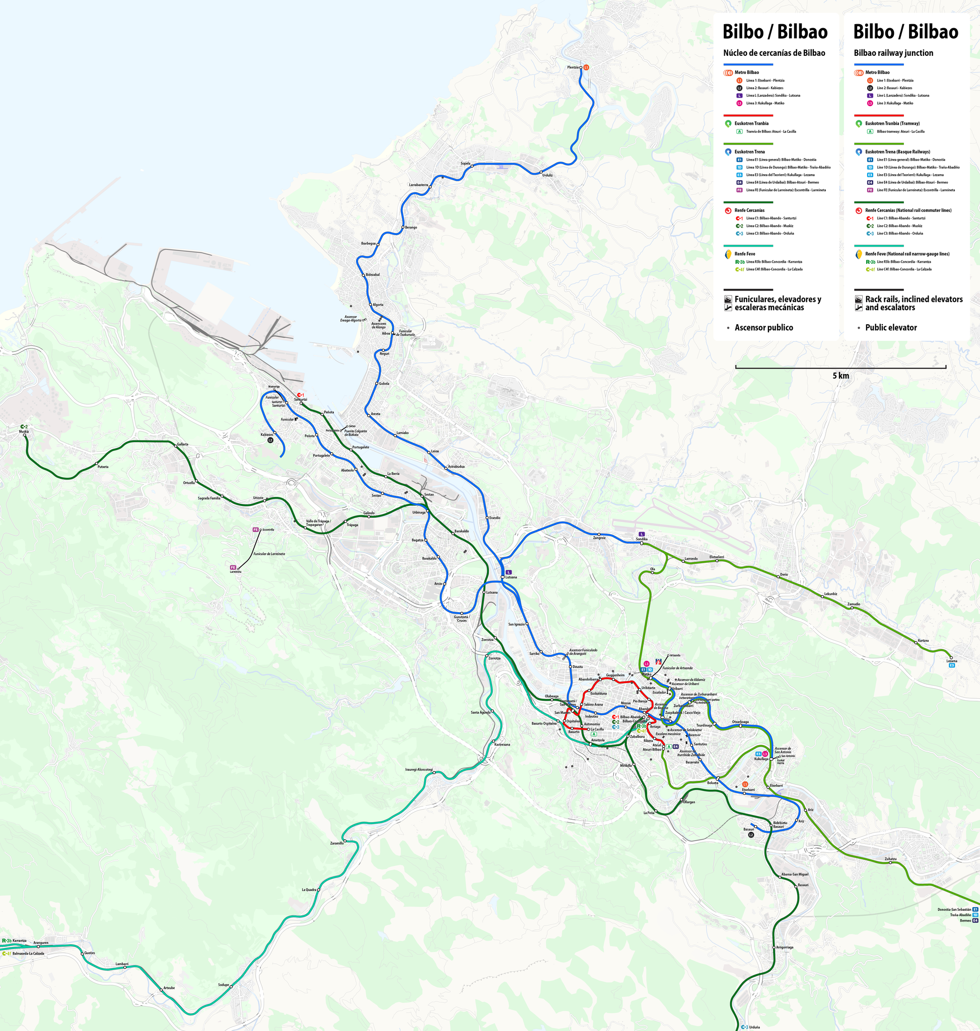
File:Public transport map of Bilbao.png

Size of this preview: 570 × 600 pixels. Other resolutions: 228 × 240 pixels | 456 × 480 pixels | 730 × 768 pixels | 973 × 1,024 pixels | 1,946 × 2,048 pixels | 4,701 × 4,948 pixels.
Original file (4,701 × 4,948 pixels, file size: 9.36 MB, MIME type: image/png)
Captions
Captions
Add a one-line explanation of what this file represents

|
This transport map image could be re-created using vector graphics as an SVG file. This has several advantages; see Commons:Media for cleanup for more information. If an SVG form of this image is available, please upload it and afterwards replace this template with
{{vector version available|new image name}}.
It is recommended to name the SVG file “Public transport map of Bilbao.svg”—then the template Vector version available (or Vva) does not need the new image name parameter. |
Summary edit
| Description |
Deutsch: Karte ÖPNV Bilbao
English: Public transport map of Bilbao
Français : Plan des Transports publics de Bilbao
Português: Mapa do transporte publico do Bilbao
|
|||
| Date | see file history | |||
| Source | Own work using: OpenStreetMap data for the background | |||
| Creator | ||||
| Permission (Reusing this file) |
All OpenStreetMap data and maps are Creative Commons "CC-BY-SA 2.0" licensed This file is licensed under the Creative Commons Attribution-Share Alike 2.0 Generic license.
|
|||
| Georeferencing | If inappropriate please set warp_status = skip to hide. | |||
| Other versions |
|

.png)
File history
Click on a date/time to view the file as it appeared at that time.
| Date/Time | Thumbnail | Dimensions | User | Comment | |
|---|---|---|---|---|---|
| current | 15:00, 3 December 2018 | | 4,701 × 4,948 (9.36 MB) | Chumwa (talk | contribs) | |
| 08:38, 3 December 2018 |  | 4,701 × 4,948 (9.37 MB) | Chumwa (talk | contribs) | ||
| 22:07, 2 December 2018 |  | 4,701 × 4,948 (9.55 MB) | Chumwa (talk | contribs) | {{SVG|transport map}} == {{int:filedesc}} == {{Map |Description= {{de|Karte ÖPNV Bilbao}} {{en|Public transport map of Bilbao}} {{fr|Plan des Transports publics de Bilbao}} {{pt|Mapa do transporte publico do Bilbao}} {{Overlay}} |Author=Maximilian Dörrbecker (Chumwa) |Source={{own using}} OpenStreetMap data for the background |Date=see file history |Permission=All OpenStreetMap data and maps are Creative Commons "CC-BY-SA 2.0" licensed{{cc-b... |
You cannot overwrite this file.
File usage on Commons
The following 8 pages use this file:
- Top 200 transport map images that should use vector graphics
- User:Chumwa/OgreBot/Potential transport maps/2018 December 1-10
- User:Chumwa/OgreBot/Public transport information/2018 December 1-10
- User:Chumwa/OgreBot/Transport Maps/2018 December 1-10
- User:Chumwa/OgreBot/Travel and communication maps/2018 December 1-10
- File:Public transport map of Bilbao.png
- File:Public transport map of Bilbao (city area).png
- Category:Bizkaiko Garraio Partzuergoa
File usage on other wikis
The following other wikis use this file:
- Usage on bn.wikipedia.org
- Usage on ca.wikipedia.org
- Usage on cs.wikipedia.org
- Usage on de.wikipedia.org
- Usage on en.wikipedia.org
- Usage on es.wikipedia.org
- Usage on et.wikipedia.org
- Usage on eu.wikipedia.org
- Usage on fa.wikipedia.org
- Usage on fi.wikivoyage.org
- Usage on fr.wikipedia.org
- Usage on gl.wikipedia.org
- Usage on hu.wikipedia.org
- Usage on it.wikipedia.org
- Usage on ja.wikipedia.org
- Usage on lmo.wikipedia.org
- Usage on lt.wikipedia.org
- Usage on nl.wikipedia.org
- Usage on no.wikipedia.org
- Usage on pl.wikipedia.org
- Usage on pt.wikipedia.org
- Usage on ru.wikipedia.org
- Usage on sv.wikipedia.org
- Usage on th.wikipedia.org
- Usage on tr.wikipedia.org
- Usage on uk.wikipedia.org
- Usage on uz.wikipedia.org
- Usage on www.wikidata.org