File:Puerto-Rico GHI mid-size-map 220x120mm-300dpi v20191205.png

Size of this preview: 800 × 436 pixels. Other resolutions: 320 × 175 pixels | 640 × 349 pixels | 1,024 × 559 pixels | 1,280 × 698 pixels | 2,598 × 1,417 pixels.
Original file (2,598 × 1,417 pixels, file size: 790 KB, MIME type: image/png)
Captions
Captions
Add a one-line explanation of what this file represents
Summary
edit
| Description |
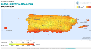
English: Global Horizontal Irradiation of Puerto Rico |
| Date | |
| Source | https://solargis.com/maps-and-gis-data/overview |
| Author | © 2019 The World Bank, Source: Global Solar Atlas 2.0, Solar resource data: Solargis. |
Licensing
edit
This file is licensed under the Creative Commons Attribution 4.0 International license.
- You are free:
- to share – to copy, distribute and transmit the work
- to remix – to adapt the work
- Under the following conditions:
- attribution – You must give appropriate credit, provide a link to the license, and indicate if changes were made. You may do so in any reasonable manner, but not in any way that suggests the licensor endorses you or your use.
File history
Click on a date/time to view the file as it appeared at that time.
| Date/Time | Thumbnail | Dimensions | User | Comment | |
|---|---|---|---|---|---|
| current | 08:31, 12 July 2020 | | 2,598 × 1,417 (790 KB) | Ponderosapine210 (talk | contribs) | Uploaded a work by © 2019 The World Bank, Source: Global Solar Atlas 2.0, Solar resource data: Solargis. from https://solargis.com/maps-and-gis-data/overview with UploadWizard |
You cannot overwrite this file.
File usage on Commons
There are no pages that use this file.