File:Pvgis solar optimum MK.png

Size of this preview: 552 × 599 pixels. Other resolutions: 221 × 240 pixels | 442 × 480 pixels | 707 × 768 pixels | 1,024 × 1,112 pixels.
Original file (1,024 × 1,112 pixels, file size: 886 KB, MIME type: image/png)
Captions
Captions
Add a one-line explanation of what this file represents
Summary
edit
| Description |
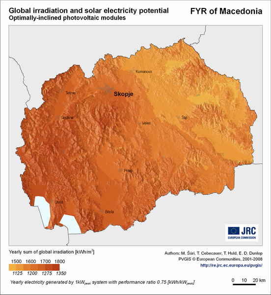
English: Solar radiation and photovoltaic electricity potential: FYR Macedonia, Europe |
|||
| Date | ||||
| Source | JRC's Institute for Energy and Transport - PVGIS - European Commission | |||
| Author | PVGIS © European Communities, 2001-2008 | |||
| Permission (Reusing this file) |
In case that you include any of these maps in your publications, please cite this reference:
|
Licensing
edit

|
The copyright holder of this file allows anyone to use it for any purpose, provided that the copyright holder is properly attributed. Redistribution, derivative work, commercial use, and all other use is permitted. |
Attribution:
PVGIS © European Communities, 2001-2008
|
This file, which was originally posted to
http://re.jrc.ec.europa.eu/pvgis/cmaps/eur.htm, was reviewed on 16 August 2012 by reviewer Lymantria, who confirmed that it was available there under the stated license on that date.
|
File history
Click on a date/time to view the file as it appeared at that time.
| Date/Time | Thumbnail | Dimensions | User | Comment | |
|---|---|---|---|---|---|
| current | 20:44, 30 July 2012 | | 1,024 × 1,112 (886 KB) | Rillke (talk | contribs) |
You cannot overwrite this file.
File usage on Commons
There are no pages that use this file.