File:PyongYang•PyongSong Urban Route Map.png

Size of this preview: 600 × 600 pixels. Other resolutions: 240 × 240 pixels | 480 × 480 pixels | 768 × 768 pixels | 1,024 × 1,024 pixels | 1,600 × 1,600 pixels.
Original file (1,600 × 1,600 pixels, file size: 408 KB, MIME type: image/png)
Captions
Captions
Add a one-line explanation of what this file represents
Summary edit
| Description |
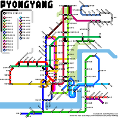
English: Pyongyang•Pyongsong City Urban Route Map |
| Date | |
| Source | Own work |
| Author | Kimbeomjun11 |
Licensing edit
I, the copyright holder of this work, hereby publish it under the following license:
| This file is made available under the Creative Commons CC0 1.0 Universal Public Domain Dedication. | |
| The person who associated a work with this deed has dedicated the work to the public domain by waiving all of their rights to the work worldwide under copyright law, including all related and neighboring rights, to the extent allowed by law. You can copy, modify, distribute and perform the work, even for commercial purposes, all without asking permission.
|

|
This map, as well as other fictitious maps, is fictitious or too incorrect (i.e. due to anachronism) to be used in real-life contexts (contemporary or historic). It may have some visual elements that are similar to official maps such as colors or certain layout features, but they are NOT official and don't have any official recognition. |
This file is uploaded through the Korean Wikipedia, which has not been reviewed on Commons.
|
File history
Click on a date/time to view the file as it appeared at that time.
| Date/Time | Thumbnail | Dimensions | User | Comment | |
|---|---|---|---|---|---|
| current | 10:58, 28 January 2024 | | 1,600 × 1,600 (408 KB) | Kimbeomjun11 (talk | contribs) | Uploaded own work with UploadWizard |
You cannot overwrite this file.
File usage on Commons
The following 3 pages use this file: