File:Pyrenees map shaded relief-sp.svg

Size of this PNG preview of this SVG file: 800 × 475 pixels. Other resolutions: 320 × 190 pixels | 640 × 380 pixels | 1,024 × 608 pixels | 1,280 × 760 pixels | 2,560 × 1,520 pixels | 3,200 × 1,900 pixels.
Original file (SVG file, nominally 3,200 × 1,900 pixels, file size: 5.58 MB)
Captions
Captions
Add a one-line explanation of what this file represents
Summary
edit
| Description |
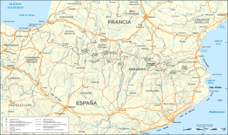
English: Map in Spanish of the Pyrenees mountains with shaded relief.
Note: The shaded relief is a raster image embedded in the SVG file. |
| Source | Own work |
| Author | FDV |
Spanish transation of "Pyrenees map shaded relief-fr.svg" by Eric Gaba (Sting - fr:Sting)
Licensing
edit
I, the copyright holder of this work, hereby publish it under the following license:
This file is licensed under the Creative Commons Attribution-Share Alike 3.0 Unported license.
- You are free:
- to share – to copy, distribute and transmit the work
- to remix – to adapt the work
- Under the following conditions:
- attribution – You must give appropriate credit, provide a link to the license, and indicate if changes were made. You may do so in any reasonable manner, but not in any way that suggests the licensor endorses you or your use.
- share alike – If you remix, transform, or build upon the material, you must distribute your contributions under the same or compatible license as the original.
File history
Click on a date/time to view the file as it appeared at that time.
| Date/Time | Thumbnail | Dimensions | User | Comment | |
|---|---|---|---|---|---|
| current | 21:00, 21 August 2009 | | 3,200 × 1,900 (5.58 MB) | FDV (talk | contribs) | Category:Maps of Pyrenees |
| 20:51, 21 August 2009 |  | 3,200 × 1,900 (5.58 MB) | FDV (talk | contribs) | {{Information |Description={{en|1=Map in Spanish of the Pyrenees mountains with shaded relief. Note: The shaded relief is a raster image embedded in the SVG file.}} |Source=trabajo propio (own work) |Author=FDV |Date= |Permission= |other_vers |
You cannot overwrite this file.
File usage on Commons
There are no pages that use this file.
File usage on other wikis
The following other wikis use this file:
- Usage on de.wikipedia.org