File:Quarry and river from Thames Path in Hartslock Woods (geograph 5976719).jpg

Size of this preview: 800 × 389 pixels. Other resolutions: 320 × 156 pixels | 640 × 311 pixels | 1,024 × 498 pixels | 1,280 × 622 pixels | 4,032 × 1,960 pixels.
Original file (4,032 × 1,960 pixels, file size: 7.41 MB, MIME type: image/jpeg)
Captions
Captions
Add a one-line explanation of what this file represents
Summary edit
.jpg&action=edit§ion=1)
| Description |
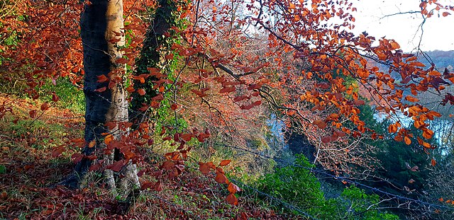
English: Quarry and river from Thames Path in Hartslock Woods. Glimpsed through the autumn foliage, the exposed limestone face of a long disused quarry can be seen in the right centre of this shot, taken from the Thames Path in Hartslock Woods. The river itself is to the right. The barbed wire in the foreground provide scant protection from the vertical quarry edge. This quarry is reputed to date back to the days of the construction of Reading Abbey, when it supplied stone by boat to the building site a few miles downstream. |
| Date | Taken on 11 November 2018 |
| Source | From geograph.org.uk |
| Author | Chris Wood |
| Permission (Reusing this file) |
Creative Commons Attribution Share-alike license 4.0 |
| Other versions | |
| Attribution (required by the license) | Chris Wood / Quarry and river from Thames Path in Hartslock Woods / |
| Camera location | | View this and other nearby images on: OpenStreetMap |
|---|
.jpg¶ms=051.503208_N_-001.107419_E_globe:Earth_type:camera_source:geograph-osgb36(SU62057863)_heading:180.00&language=en)
| Object location | | View this and other nearby images on: OpenStreetMap |
|---|
.jpg¶ms=051.502130_N_-001.107580_E_globe:Earth_class:object_type:object_source:geograph-osgb36(SU62047851)_heading:180.00&language=en)
Licensing edit
.jpg&action=edit§ion=2)
I, the copyright holder of this work, hereby publish it under the following license:
This file is licensed under the Creative Commons Attribution-Share Alike 4.0 International license.
- You are free:
- to share – to copy, distribute and transmit the work
- to remix – to adapt the work
- Under the following conditions:
- attribution – You must give appropriate credit, provide a link to the license, and indicate if changes were made. You may do so in any reasonable manner, but not in any way that suggests the licensor endorses you or your use.
- share alike – If you remix, transform, or build upon the material, you must distribute your contributions under the same or compatible license as the original.
File history
Click on a date/time to view the file as it appeared at that time.
| Date/Time | Thumbnail | Dimensions | User | Comment | |
|---|---|---|---|---|---|
| current | 16:25, 16 May 2022 | | 4,032 × 1,960 (7.41 MB) | Chris j wood (talk | contribs) | == {{int:filedesc}} == {{Information |Description={{en|1=Quarry and river from Thames Path in Hartslock Woods. Glimpsed through the autumn foliage, the exposed limestone face of a long disused quarry can be seen in the right centre of this shot, taken from the Thames Path in Hartslock Woods. The river itself is to the right. The barbed wire in the foreground provide scant protection from the vertical quarry edge. This quarry is reputed to date back to the days of the construction of Reading A... |
You cannot overwrite this file.
File usage on Commons
There are no pages that use this file.
.jpg&oldid=657051723)