File:Quartz-calcite-dolomite vein in New Albany Shale (Upper Devonian; Interstate 65 entrance ramp roadcut, Bullitt County, Kentucky, USA) 2.jpg

Original file (1,280 × 960 pixels, file size: 1.16 MB, MIME type: image/jpeg)
Captions
Captions
Summary edit
_2.jpg&action=edit§ion=1)
| Description |
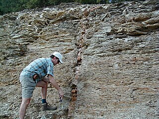
English: Vein in weathered shales in the Devonian of Kentucky, USA.
These are weathered shales in the New Albany Shale, a Devonian-aged formation in Kentucky, Indiana, Illinois, and eastern Missouri. The unit is dominated by dark-colored marine mudshales of Late Devonian age. These black shales were deposited in a moderately deep, anoxic seafloor environment. This was a widespread lithofacies during the Late Devonian's Global Anoxia Event. The New Albany Shale is equivalent to the Ohio Shale, the Antrim Shale, and the Chattanooga Shale in surrounding states. The New Albany Shale's member terminology varies from region to region. In southern Indiana and adjacent areas of Kentucky, the New Albany consists of (from the base upward): Blocher Member, Selmier Member, Morgan Trail Member, Camp Run Member, and Clegg Creek Member. The wall seen here has an obvious, vertically-oriented vein cross-cutting the shales. The vein intruded when the surrounding shales were semi-solidified. Vein fills are squished, contorted, and telescoped vertically - the vein compacted when the shales had not completed compaction themselves. It's estimated that the vein compacted when the shales had 20 to 30% porosity, at about ~500 meters burial depth. Vein fill materials include quartz (SiO2), calcite (CaCO3), dolomite (CaMg(CO3)2) and a trace of bitumen. Vein intrusion is related to large-scale fluid migration from basins to high areas (regional arches). The vein's host rocks are the upper Camp Run Member and the Clegg Creek Member. Stratigraphy: upper New Albany Shale, Famennian Stage, upper Upper Devonian Locality: roadcut along the western side of the south-bound entrance ramp to Interstate 65 at the Route 245-Interstate 65 interchange, north-northeast of Belmont & south of Sherpherdsville, south-central Bullitt County, north-central Kentucky, USA (37° 55' 24.45" North latitude, 85° 41' 18.33" West longitude) |
| Date | |
| Source | https://www.flickr.com/photos/47445767@N05/52873406387/ |
| Author | James St. John |
Licensing edit
_2.jpg&action=edit§ion=2)
- You are free:
- to share – to copy, distribute and transmit the work
- to remix – to adapt the work
- Under the following conditions:
- attribution – You must give appropriate credit, provide a link to the license, and indicate if changes were made. You may do so in any reasonable manner, but not in any way that suggests the licensor endorses you or your use.
| This image was originally posted to Flickr by James St. John at https://flickr.com/photos/47445767@N05/52873406387. It was reviewed on 9 May 2023 by FlickreviewR 2 and was confirmed to be licensed under the terms of the cc-by-2.0. |
File history
Click on a date/time to view the file as it appeared at that time.
| Date/Time | Thumbnail | Dimensions | User | Comment | |
|---|---|---|---|---|---|
| current | 02:01, 9 May 2023 | | 1,280 × 960 (1.16 MB) | Ser Amantio di Nicolao (talk | contribs) | Uploaded a work by James St. John from https://www.flickr.com/photos/47445767@N05/52873406387/ with UploadWizard |
You cannot overwrite this file.
File usage on Commons
There are no pages that use this file.
_2.jpg&oldid=762025680)