File:Queen Street - geograph.org.uk - 1253032.jpg
Size of this preview: 450 × 600 pixels. Other resolutions: 180 × 240 pixels | 480 × 640 pixels.
Original file (480 × 640 pixels, file size: 73 KB, MIME type: image/jpeg)
Captions
Captions
Add a one-line explanation of what this file represents
Summary
edit
| Description |
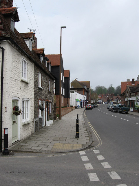
English: Queen Street Taken from the junction with Queens Lane. The road is the main southern entrance into Arundel following the course of a medieval causeway built by monks in the 12th century before reaching a ferry until that was replaced by a bridge in the mid 13th century. The building beyond the cottages are on the site of a former brewery whilst the block of flats beyond are on the site of the old Bridge Hotel which collapsed into the river soon after the building of the new bridge in the 1930s. |
| Date | |
| Source | From geograph.org.uk |
| Author | Simon Carey |
| Attribution (required by the license) | Simon Carey / Queen Street / |
| Camera location | | View this and other nearby images on: OpenStreetMap |
|---|
_heading:337.00&language=en)
| Object location | | View this and other nearby images on: OpenStreetMap |
|---|
_heading:337.00&language=en)
Licensing
edit

|
This image was taken from the Geograph project collection. See this photograph's page on the Geograph website for the photographer's contact details. The copyright on this image is owned by Simon Carey and is licensed for reuse under the Creative Commons Attribution-ShareAlike 2.0 license.
|
This file is licensed under the Creative Commons Attribution-Share Alike 2.0 Generic license.
Attribution: Simon Carey
- You are free:
- to share – to copy, distribute and transmit the work
- to remix – to adapt the work
- Under the following conditions:
- attribution – You must give appropriate credit, provide a link to the license, and indicate if changes were made. You may do so in any reasonable manner, but not in any way that suggests the licensor endorses you or your use.
- share alike – If you remix, transform, or build upon the material, you must distribute your contributions under the same or compatible license as the original.
File history
Click on a date/time to view the file as it appeared at that time.
| Date/Time | Thumbnail | Dimensions | User | Comment | |
|---|---|---|---|---|---|
| current | 20:54, 26 February 2011 | | 480 × 640 (73 KB) | GeographBot (talk | contribs) | == {{int:filedesc}} == {{Information |description={{en|1=Queen Street Taken from the junction with Queens Lane. The road is the main southern entrance into Arundel following the course of a medieval causeway built by monks in the 12th century before reach |
You cannot overwrite this file.
File usage on Commons
There are no pages that use this file.