File:Qutub minar-vnegi2020.jpg

Size of this preview: 800 × 533 pixels. Other resolutions: 320 × 213 pixels | 640 × 427 pixels | 1,024 × 683 pixels | 1,280 × 853 pixels | 2,560 × 1,707 pixels | 6,000 × 4,000 pixels.
Original file (6,000 × 4,000 pixels, file size: 8.9 MB, MIME type: image/jpeg)
Captions
Captions
Add a one-line explanation of what this file represents
Summary edit
| Description |
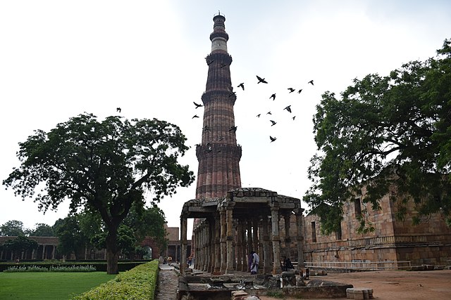
English: Qutb Minar,[1][2] (also spelled Qutub Minar) at 73 metres, is the tallest brick minaret in the world and second highest minar in india after Fateh burj at Mohalli(punjab). Qutb Minar, along with the ancient and medieval monuments surrounding it, form the Qutb Complex, which is a UNESCO World Heritage Site.[2][3][3] The tower is located in the Mehrauli area of Delhi, India.The Minaret of Jam, a UNESCO World Heritage Site in western Afghanistan, is thought to have been a direct inspiration for the Qutb Minar in Delhi, which was also built by the Ghorid Dynasty. Made of red sandstone and marble, Qutb Minar is a 73-metres (240 feet) tall tapering tower with a diameter measuring 14.32 metres (47 feet) at the base and 2.75 metres (9 feet) at the peak.[4] Inside the tower, a circular staircase with 379 steps leads to the top.[5] Qutb Minar station is the closest station on the Delhi Metro.
In 1200 AD, Qutb al-Din Aibak, the founder of the Delhi Sultanate started construction of the Qutb Minar. In 1220, Aibak's successor and son-in-law Iltutmish added three storeys to the tower. In 1369, lightning struck the top storey, destroying it completely. So, Firoz Shah Tughlaq carried out restoration work replacing the damaged storey with two new storeys every year, made of red sandstone and white marble.[6][7] Qutb Minar is surrounded by several historically significant monuments, which are historically connected with the tower and are part of the Qutb Complex. These include the Iron Pillar of Delhi, Quwwat-ul-Islam Mosque, Alai Darwaza, the Tomb of Iltutmish, Alai Minar, Ala-ud-din's Madrasa and Tomb, and the Tomb of Imam Zamin. Other minor monuments include Major Smith's Cupola and Sanderson's Sundial.
|
||
| Date | |||
| Source | Own work | ||
| Author | vineet negi |
| Camera location | | View this and other nearby images on: OpenStreetMap |
|---|
Licensing edit
I, the copyright holder of this work, hereby publish it under the following license:
This file is licensed under the Creative Commons Attribution-Share Alike 4.0 International license.
- You are free:
- to share – to copy, distribute and transmit the work
- to remix – to adapt the work
- Under the following conditions:
- attribution – You must give appropriate credit, provide a link to the license, and indicate if changes were made. You may do so in any reasonable manner, but not in any way that suggests the licensor endorses you or your use.
- share alike – If you remix, transform, or build upon the material, you must distribute your contributions under the same or compatible license as the original.

|
This image was uploaded as part of Wiki Loves Monuments 2016.
|
 |
File history
Click on a date/time to view the file as it appeared at that time.
| Date/Time | Thumbnail | Dimensions | User | Comment | |
|---|---|---|---|---|---|
| current | 16:46, 30 September 2016 | | 6,000 × 4,000 (8.9 MB) | Vnegi2020 (talk | contribs) | User created page with UploadWizard |
You cannot overwrite this file.
File usage on Commons
There are no pages that use this file.