File:RK 1504 0205 HohesElbufer.jpg

Size of this preview: 800 × 533 pixels. Other resolutions: 320 × 213 pixels | 640 × 427 pixels | 1,024 × 683 pixels | 1,280 × 853 pixels | 2,100 × 1,400 pixels.
Original file (2,100 × 1,400 pixels, file size: 1.39 MB, MIME type: image/jpeg)
Captions
Captions
Add a one-line explanation of what this file represents
Summary edit
| Description |
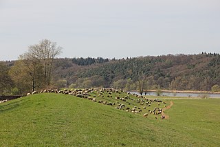
Deutsch: Naturschutzgebiet Hohes Elbufer zwischen Tesperhude und Lauenburg von der gegenüberliegenden Seite der Elbe bei Artlenburg aufgenommen. |
|||||||||||||||||
| Date | Taken on 20 April 201517:12:14 | |||||||||||||||||
| Source | Own work | |||||||||||||||||
| Author |
|
|||||||||||||||||

| Camera location | | View this and other nearby images on: OpenStreetMap |
|---|
Licensing edit

1. Provide a copy of, or the URI for, the applicable license: https://creativecommons.org/licenses/by-sa/4.0/de/legalcode,
2. my name as given above,
3. the title of the work,
4. in the case of an adaptation, a credit identifying the use of the work in the adaptation.
This license and the rights granted hereunder will terminate automatically upon any breach by you of the terms of this license. Any of the above conditions can be waived if you get permission from the copyright holder. If you have questions or wish differing conditions or a higher resolution, please contact me through: E-Mail via Wikipedia or my discussion page
This file is licensed under the Creative Commons Attribution-Share Alike 4.0 International license.
Attribution: Foto: Reinhard Kraasch, Lizenz: CC-BY-SA 4.0 DE
- You are free:
- to share – to copy, distribute and transmit the work
- to remix – to adapt the work
- Under the following conditions:
- attribution – You must give appropriate credit, provide a link to the license, and indicate if changes were made. You may do so in any reasonable manner, but not in any way that suggests the licensor endorses you or your use.
- share alike – If you remix, transform, or build upon the material, you must distribute your contributions under the same or compatible license as the original.
This image was uploaded as part of Wiki Loves Earth 2015.
|
 |
File history
Click on a date/time to view the file as it appeared at that time.
| Date/Time | Thumbnail | Dimensions | User | Comment | |
|---|---|---|---|---|---|
| current | 18:27, 31 May 2015 | | 2,100 × 1,400 (1.39 MB) | Reinhard Kraasch (talk | contribs) | User created page with UploadWizard |
You cannot overwrite this file.
File usage on Commons
The following 2 pages use this file: