File:RO Umgebung.png

Size of this preview: 482 × 600 pixels. Other resolutions: 193 × 240 pixels | 386 × 480 pixels | 775 × 964 pixels.
Original file (775 × 964 pixels, file size: 363 KB, MIME type: image/png)
Captions
Captions
Add a one-line explanation of what this file represents
Summary
edit
| Description |
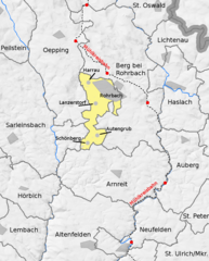
English: municipality map of Rohrbach with neighbour municipalities
Deutsch: Gemeindegliederung von Rohrbach mit Nachbargemeinden. Lage der Ortschaften in der Stadtgemeinde Rohrbach unter Nutzung der von DORIS als freier Download bereit gestellten Straßenkarte OE200 erstellt |
| Date | |
| Source | Eigenes Werk (own work) und DORIS, OÖ |
| Author | Hjanko |
Licensing
edit
I, the copyright holder of this work, hereby publish it under the following licenses:

|
Permission is granted to copy, distribute and/or modify this document under the terms of the GNU Free Documentation License, Version 1.2 or any later version published by the Free Software Foundation; with no Invariant Sections, no Front-Cover Texts, and no Back-Cover Texts. A copy of the license is included in the section entitled GNU Free Documentation License. |
This file is licensed under the Creative Commons Attribution-Share Alike 3.0 Unported license.
- You are free:
- to share – to copy, distribute and transmit the work
- to remix – to adapt the work
- Under the following conditions:
- attribution – You must give appropriate credit, provide a link to the license, and indicate if changes were made. You may do so in any reasonable manner, but not in any way that suggests the licensor endorses you or your use.
- share alike – If you remix, transform, or build upon the material, you must distribute your contributions under the same or compatible license as the original.
You may select the license of your choice.
File history
Click on a date/time to view the file as it appeared at that time.
| Date/Time | Thumbnail | Dimensions | User | Comment | |
|---|---|---|---|---|---|
| current | 15:24, 11 May 2009 | | 775 × 964 (363 KB) | Hjanko (talk | contribs) | Tippfehler korrigiert (Lanzersdorf -> Lanzerstorf) |
| 17:29, 9 May 2009 |  | 775 × 964 (361 KB) | Hjanko (talk | contribs) | Bahnlinie benannt und Bahnhöf/Haltestellen eingezeichnet | |
| 19:04, 8 May 2009 |  | 775 × 964 (351 KB) | Hjanko (talk | contribs) | {{Information |Description={{en|1=municipality map of Rohrbach with neighbour municipalities}} {{de|1=Gemeindegliederung von Rohrbach mit Nachbargemeinden}} |Source=Eigenes Werk (own work) |Author=Hjanko |Date=8. Mai 2009 |Permission= |oth |
You cannot overwrite this file.
File usage on Commons
There are no pages that use this file.
File usage on other wikis
The following other wikis use this file:
- Usage on de.wikipedia.org