File:RU-MOS-Istrinsky-outline.svg

Original file (SVG file, nominally 706 × 507 pixels, file size: 1.33 MB)
Captions
Captions
Summary edit
| Description |
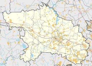
Русский: Карта, Истринский район Московской области. |
| Date | |
| Source | Own work using Maperitive tool on OpenStreetMap data, then Inkscape |
| Author | OpenStreetMap contributors & Nzeemin |
Licensing edit
| Description |
This map was created from OpenStreetMap project data, collected by the community. This map may be incomplete, and may contain errors. Don't rely solely on it for navigation. |
|||
| Date | (see file history) | |||
| Source | openstreetmap.org | |||
| Creator |
OpenStreetMap contributors |
|||
| Permission (Reusing this file) |
OpenStreetMap data is available under the Open Database License (details). Map tiles are licensed under the Creative Commons Attribution-ShareAlike 2.0 license (CC-BY-SA 2.0).
This file is licensed under the Creative Commons Attribution-Share Alike 2.0 Generic license.
|
|||
| Georeferencing | If inappropriate please set warp_status = skip to hide. |
Details edit
Maperitive commands:
set-geo-bounds 36.23,55.75,37.2,56.14
set-print-bounds-geo
zoom 10
export-svg compatibility=inkscape
File history
Click on a date/time to view the file as it appeared at that time.
| Date/Time | Thumbnail | Dimensions | User | Comment | |
|---|---|---|---|---|---|
| current | 14:40, 16 March 2014 | | 706 × 507 (1.33 MB) | Nzeemin (talk | contribs) | User created page with UploadWizard |
You cannot overwrite this file.
File usage on Commons
The following page uses this file:
File usage on other wikis
The following other wikis use this file:
- Usage on ce.wikipedia.org
- Usage on hy.wikipedia.org
- Usage on myv.wikipedia.org
- Usage on os.wikipedia.org
- Usage on ru.wikipedia.org
- Истринское водохранилище
- Истринский район
- Кострово (Московская область)
- Рождествено (село, городской округ Истра)
- Даренка (приток Песочной)
- Красновидово (городской округ Истра)
- Борки (городской округ Истра)
- Ивановское (деревня, городской округ Истра)
- Посёлок опытного производственного хозяйства «Манихино»
- Павловское (городской округ Истра)
- Троицкий (Московская область)
- Петушки (городской округ Истра)
- Маглуша
- Новораково
- Павловская Слобода
- Глебово-Избище
- Мазилово (Московская область)
- Полевшина
- Крюково (городской округ Истра)
- Ламоново (городской округ Истра)
- Ленино (Московская область)
- Болденка (река)
- Молодильня
- Разварня
- Раменка (река, впадает в Истринское водохранилище)
- Шебаново (городской округ Истра)
- Песочная (приток Истры)
- Санниково (Московская область)
- Борзые (деревня)
- Ядромино
- Лесодолгоруково
- Румянцево (городской округ Истра)
- Деньково (Московская область)
- Ильино (городской округ Истра)
- Савельево (городской округ Истра)
- Чаново (Московская область)
- Красный (Московская область)
- Хмолино
- Мыканино (городской округ Истра)
- Зенькино (Московская область)
- Октябрьский (городской округ Истра)
- Филатово (городской округ Истра)
- Кучи (сельское поселение Букарёвское)
- Дедёшино (городской округ Истра)
View more global usage of this file.