File:Radar-CAPPI example2.gif
No higher resolution available.
Radar-CAPPI_example2.gif (580 × 480 pixels, file size: 38 KB, MIME type: image/gif)
Captions
Captions
Add a one-line explanation of what this file represents
Summary edit
| Description |
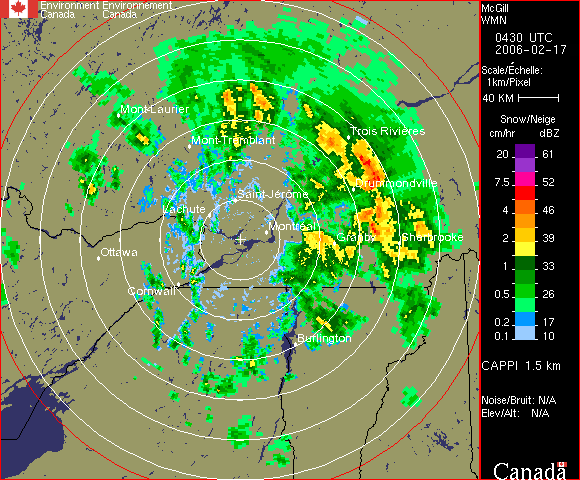
English: Example of Constant Altitude Weather Radar output (CAPPI). Contrary to PPI which are data from and fix angle of elevation, CAPPIs use the data from all angles nearest a fixed altitude to compose an horizontal slice of the precipitations.
Français : Contrairement aux PPI (vue panoramique à un angle d'élévation) qui s'éloigne du sol avec la distance, le CAPPI (exemple) est une coupe horizontale des données radar à une altitude donnée. |
| Date | |
| Source | Meteorological Service of Canada (Environment Canada) that allow redistribution if source mentionned. |
| Author | Unknown author |
Licensing edit

|
The copyright holder of this file, Environnement Canada, allows anyone to use it for any purpose, provided that the copyright holder is properly attributed. Redistribution, derivative work, commercial use, and all other use is permitted. |
Attribution:
Environnement Canada
|
File history
Click on a date/time to view the file as it appeared at that time.
| Date/Time | Thumbnail | Dimensions | User | Comment | |
|---|---|---|---|---|---|
| current | 04:41, 17 February 2006 | | 580 × 480 (38 KB) | Pierre cb (talk | contribs) | Example of precipitation on a CAPPI. The data are at constant altitude contrary to a PPI. Exemple de données à altitude constante de réflectivité radar. |
You cannot overwrite this file.
File usage on Commons
The following 2 pages use this file:
File usage on other wikis
The following other wikis use this file:
- Usage on de.wikipedia.org
- Usage on en.wikipedia.org
- Usage on es.wikipedia.org
- Usage on fr.wikipedia.org