File:Railways in Congo.svg

Size of this PNG preview of this SVG file: 350 × 250 pixels. Other resolutions: 320 × 229 pixels | 640 × 457 pixels | 1,024 × 731 pixels | 1,280 × 914 pixels | 2,560 × 1,829 pixels.
Original file (SVG file, nominally 350 × 250 pixels, file size: 22 KB)
Captions
Captions
Add a one-line explanation of what this file represents
Summary edit
| Description |
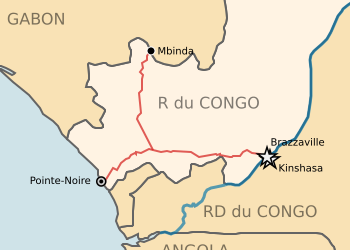
English: Railway network of Republic of Congo
Legend:
Polski: Sieć kolejowa Republiki Konga
Legenda:
|
| Date | |
| Source | http://sharemap.org/jkan/railway/Railways%20in%20Congo |
| Author | Jkan997 |
| SVG development | This map was created with ShareMap.org. |
Licensing edit
I, the copyright holder of this work, hereby publish it under the following license:
This file is licensed under the Creative Commons Attribution 3.0 Unported license.
- You are free:
- to share – to copy, distribute and transmit the work
- to remix – to adapt the work
- Under the following conditions:
- attribution – You must give appropriate credit, provide a link to the license, and indicate if changes were made. You may do so in any reasonable manner, but not in any way that suggests the licensor endorses you or your use.
File history
Click on a date/time to view the file as it appeared at that time.
| Date/Time | Thumbnail | Dimensions | User | Comment | |
|---|---|---|---|---|---|
| current | 10:20, 9 November 2017 | | 350 × 250 (22 KB) | Ypirétis (talk | contribs) | Corrections cacographies |
| 22:11, 6 July 2011 |  | 350 × 250 (22 KB) | Jkan997 (talk | contribs) | {{Information |Description ={{en|1=Railway network of Republic of Congo}} |Source ={{own}} |Author =Jkan997 |Date = |Permission = |other_versions = }} |
You cannot overwrite this file.
File usage on Commons
The following 6 pages use this file:
- User:Chumwa/OgreBot/Potential transport maps/2017 November 1-10
- User:Chumwa/OgreBot/Public transport information/2017 November 1-10
- User:Chumwa/OgreBot/Transport Maps/2017 November 1-10
- User:Chumwa/OgreBot/Travel and communication maps/2017 November 1-10
- User:Jkan997
- Category:Chemin de fer Congo–Océan
File usage on other wikis
The following other wikis use this file:
- Usage on de.wikipedia.org
- Usage on en.wikipedia.org
- Usage on es.wikipedia.org
- Usage on fr.wikivoyage.org
- Usage on ha.wikipedia.org
- Usage on hu.wikipedia.org
- Usage on ja.wikipedia.org
- Usage on ka.wikipedia.org
- Usage on pl.wikipedia.org
- Usage on ru.wikipedia.org
- Usage on uk.wikipedia.org
- Usage on www.wikidata.org
- Usage on zh.wikipedia.org