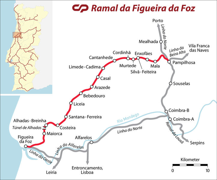
File:Ramal da Figueira da Foz.png

Size of this preview: 722 × 600 pixels. Other resolutions: 289 × 240 pixels | 578 × 480 pixels | 924 × 768 pixels | 1,233 × 1,024 pixels | 1,697 × 1,410 pixels.
Original file (1,697 × 1,410 pixels, file size: 269 KB, MIME type: image/png)
Captions
Captions
Add a one-line explanation of what this file represents
| Description |
|
| Date | |
| Source |
Self made, using the following images and base maps: |
| Author | Maximilian Dörrbecker (Chumwa) |
| Permission (Reusing this file) |
I, the copyright holder of this work, hereby publish it under the following license: This file is licensed under the Creative Commons Attribution-Share Alike 2.5 Generic license.
Sie dürfen das Bild zu den folgenden Bedingungen nutzen:
|
| Other versions |
Derivative works of this file: Pt ferv.png
|


File history
Click on a date/time to view the file as it appeared at that time.
| Date/Time | Thumbnail | Dimensions | User | Comment | |
|---|---|---|---|---|---|
| current | 15:19, 4 May 2008 | | 1,697 × 1,410 (269 KB) | Chumwa (talk | contribs) | Some corrections - hints given by Jcornelius (thanks for that!) |
| 07:55, 4 May 2008 |  | 1,697 × 1,410 (261 KB) | Chumwa (talk | contribs) | {{Information |Description= *{{ de }} Orientierungskarte für die Metro Mondego *{{ en }} Locator Map for the Metro Mondego |Source=Self made, using the following images and base maps: * Image:Portuguese Districts Map.svg * Image:Portugal CP.svg |
You cannot overwrite this file.
File usage on Commons
The following 10 pages use this file:
- User:Chumwa/Gallery
- File:LogoMetroMondego(m).png
- File:Metro Mondego - Map of Possible Future Routes.png
- File:Metro Mondego - Route Map.png
- File:Metro Mondego - Route Map with Satellite Image as Background.jpg
- File:Pt ferv.png
- File:Ramal da Figueira da Foz.png
- File:Ramal de Alfarelos.png
- File:Ramal de Alfarelos 2.png
- Category:Ramal da Figueira da Foz
.png)
File usage on other wikis
The following other wikis use this file:
- Usage on de.wikipedia.org
- Usage on en.wikipedia.org
- Usage on it.wikipedia.org
- Usage on pt.wikipedia.org
- Usage on www.wikidata.org