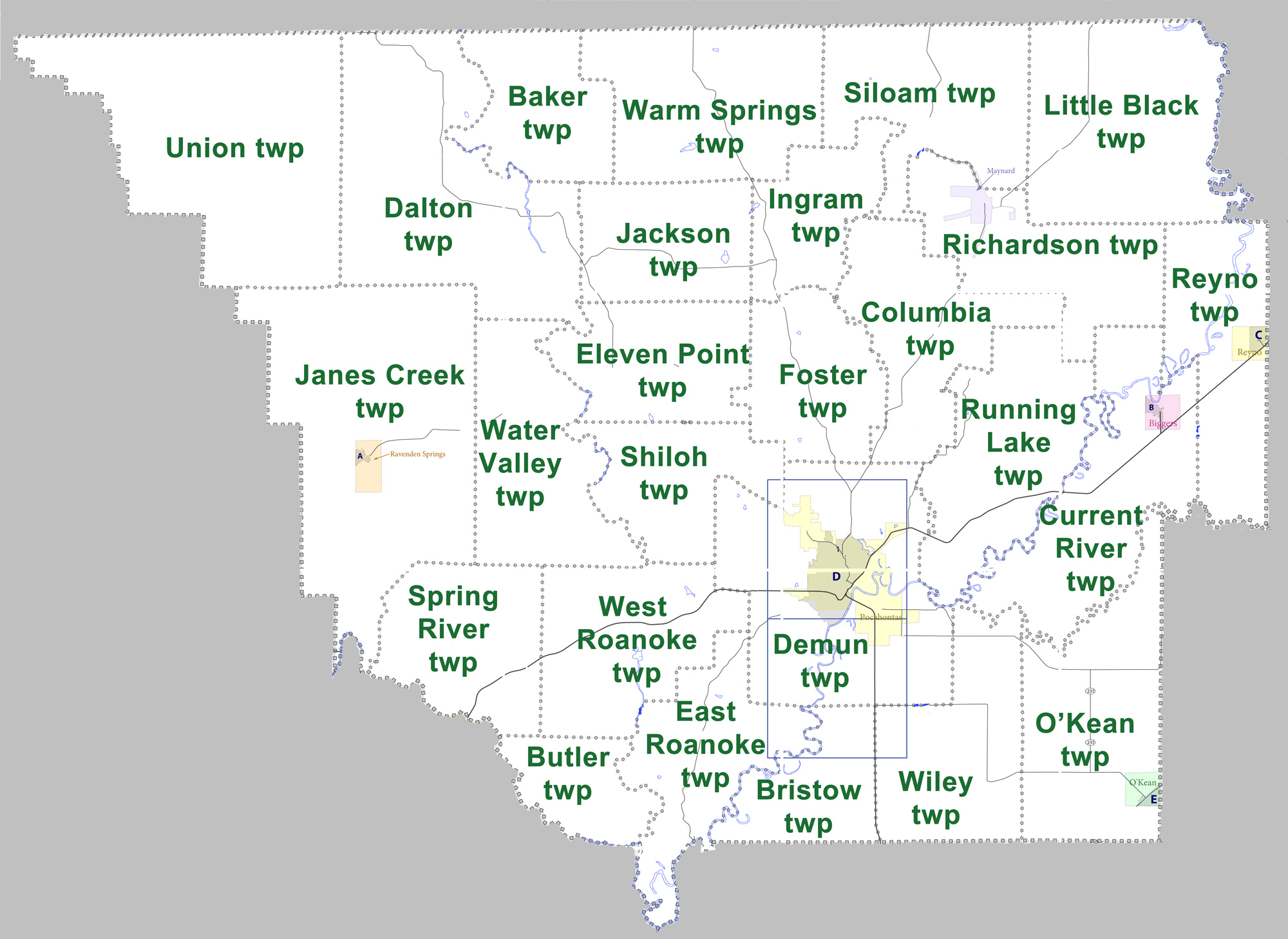
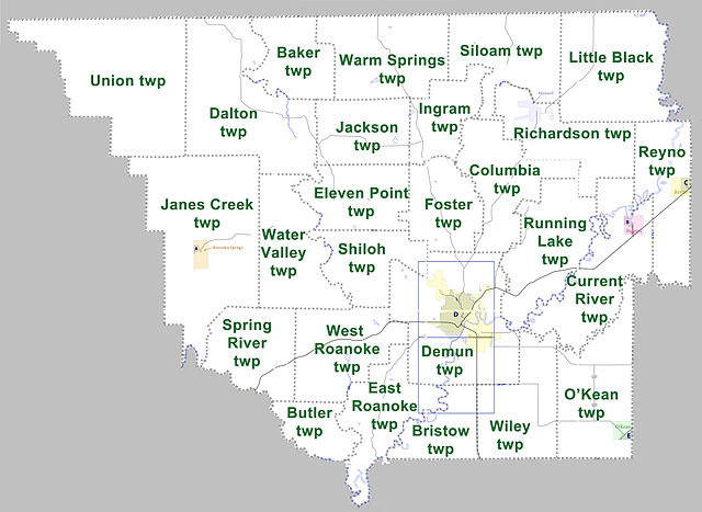
File:Randolph County Arkansas 2010 Township Map large.jpg
Size of this preview: 800 × 583 pixels. Other resolutions: 320 × 233 pixels | 640 × 467 pixels | 1,024 × 746 pixels | 1,280 × 933 pixels | 2,000 × 1,458 pixels.
Original file (2,000 × 1,458 pixels, file size: 653 KB, MIME type: image/jpeg)
Captions
Captions
Add a one-line explanation of what this file represents
Summary
edit
| Description |
English: Large map showing townships in Randolph County, Arkansas. Modified from US census map (for 2010 census) for Randolph County, Arkansas |
| Date | 7 August 2011 (original upload date) |
| Source | Transferred from en.wikipedia to Commons. |
| Author | Yx7791 at English Wikipedia |
Licensing
edit
Yx7791 at English Wikipedia, the copyright holder of this work, hereby publishes it under the following license:
| This file is made available under the Creative Commons CC0 1.0 Universal Public Domain Dedication. | |
| The person who associated a work with this deed has dedicated the work to the public domain by waiving all of their rights to the work worldwide under copyright law, including all related and neighboring rights, to the extent allowed by law. You can copy, modify, distribute and perform the work, even for commercial purposes, all without asking permission.
|
Original upload log
edit
The original description page was here. All following user names refer to en.wikipedia.
- 2011-08-07 07:05 Yx7791 2000×1458× (669064 bytes) Large map showing townships in Randolph County, Arkansas. Modified from [http://www2.census.gov/geo/maps/dc10map/GUBlock/st05_ar/county/c05121_randolph/DC10BLK_C05121_000.pdf US census map (for 2010 census) for Randolph County, Arkansas]
File history
Click on a date/time to view the file as it appeared at that time.
| Date/Time | Thumbnail | Dimensions | User | Comment | |
|---|---|---|---|---|---|
| current | 17:38, 30 August 2012 | | 2,000 × 1,458 (653 KB) | MGA73bot2 (talk | contribs) | {{BotMoveToCommons|en.wikipedia|year={{subst:CURRENTYEAR}}|month={{subst:CURRENTMONTHNAME}}|day={{subst:CURRENTDAY}}}} {{Information |Description={{en|Large map showing townships in Randolph County, Arkansas. Modified from [http://www2.census.gov/geo... |
You cannot overwrite this file.
File usage on Commons
There are no pages that use this file.
File usage on other wikis
The following other wikis use this file:
- Usage on de.wikipedia.org
- Usage on en.wikipedia.org
- Usage on es.wikipedia.org
- Usage on vi.wikipedia.org
- Xã Baker, Quận Randolph, Arkansas
- Xã Bristow, Quận Randolph, Arkansas
- Xã Butler, Quận Randolph, Arkansas
- Xã Columbia, Quận Randolph, Arkansas
- Xã Current River, Quận Randolph, Arkansas
- Xã Dalton, Quận Randolph, Arkansas
- Xã Demun, Quận Randolph, Arkansas
- Xã East Roanoke, Quận Randolph, Arkansas
- Xã Eleven Point, Quận Randolph, Arkansas
- Xã Foster, Quận Randolph, Arkansas
- Xã Ingram, Quận Randolph, Arkansas
- Xã Jackson, Quận Randolph, Arkansas
- Xã Janes Creek, Quận Randolph, Arkansas
- Xã Little Black, Quận Randolph, Arkansas
- Xã O'Kean, Quận Randolph, Arkansas
- Xã Reyno, Quận Randolph, Arkansas
- Xã Richardson, Quận Randolph, Arkansas
- Xã Running Lake, Quận Randolph, Arkansas
- Xã Shiloh, Quận Randolph, Arkansas
- Xã Siloam, Quận Randolph, Arkansas
- Xã Spring River, Quận Randolph, Arkansas
- Xã Union, Quận Randolph, Arkansas
- Xã Warm Springs, Quận Randolph, Arkansas
- Xã Water Valley, Quận Randolph, Arkansas
- Xã West Roanoke, Quận Randolph, Arkansas
- Xã Wiley, Quận Randolph, Arkansas