File:Rarh.jpg
Rarh.jpg (250 × 250 pixels, file size: 52 KB, MIME type: image/jpeg)
Captions
Captions
Summary edit
| Description |
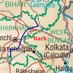
English: Map showing the region of Rarh. |
| Date | |
| Source |
https://www.lib.utexas.edu/maps/ https://www.lib.utexas.edu/maps/middle_east_and_asia/india_physio-2001.jpg (Original file) |
| Author | University of Texas Libraries |
Rarh is a high, undulating continuation of the Chota Nagpur Plateau to the west, and the Ganges Delta to the east. The Bhagirathi river, a distributary of the Ganges (seen flowing just west of Kolkata in the map) forms the eastern boundary of Rarh. The northeastern extension of Jharkhand is also part of Rarh and forms the northern boundary. Odisha and the Bay of Bengal forms the southern boundary. The natural high lands at the eastern end of the Chota Nagpur Plateau (shown here approximately, as a dark blue line passing east of Ranchi) form the western boundary of Rarh.
Licensing edit
| This file is made available under the Creative Commons CC0 1.0 Universal Public Domain Dedication. | |
| The person who associated a work with this deed has dedicated the work to the public domain by waiving all of their rights to the work worldwide under copyright law, including all related and neighboring rights, to the extent allowed by law. You can copy, modify, distribute and perform the work, even for commercial purposes, all without asking permission.
|
File history
Click on a date/time to view the file as it appeared at that time.
| Date/Time | Thumbnail | Dimensions | User | Comment | |
|---|---|---|---|---|---|
| current | 16:25, 21 August 2017 | | 250 × 250 (52 KB) | Universal Life (talk | contribs) | Better version, 250x250 and the western border is clearer. |
| 15:03, 21 August 2017 |  | 276 × 261 (56 KB) | Universal Life (talk | contribs) | Indicated better the boundaries of Rarh. | |
| 14:12, 21 August 2017 |  | 219 × 261 (36 KB) | Universal Life (talk | contribs) | Cropped the western part of Jharkhand that wasn't part of Rarh. | |
| 13:57, 21 August 2017 |  | 276 × 261 (42 KB) | Universal Life (talk | contribs) | Zoomed better to the area that's Rarh, the previous map could be a bit confusing. | |
| 13:24, 20 August 2017 |  | 348 × 306 (57 KB) | Universal Life (talk | contribs) | User created page with UploadWizard |
You cannot overwrite this file.
File usage on Commons
The following page uses this file:
File usage on other wikis
The following other wikis use this file:
- Usage on bn.wikipedia.org
- Usage on ca.wikipedia.org
- Usage on en.wikipedia.org
- Usage on www.wikidata.org