File:Rashtrakuta territories.png
No higher resolution available.
Rashtrakuta_territories.png (270 × 143 pixels, file size: 9 KB, MIME type: image/png)
Captions
Captions
Add a one-line explanation of what this file represents
Summary
edit

|
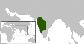
This map has been uploaded by Electionworld from en.wikipedia.org to enable the |
Map showing the extent of Rashtrakuta territories (based on www.kamat.com).
Created using the Wiki blank maps
Licensing
edit
Venu62, the copyright holder of this work, hereby publishes it under the following license:

|
Permission is granted to copy, distribute and/or modify this document under the terms of the GNU Free Documentation License, Version 1.2 or any later version published by the Free Software Foundation; with no Invariant Sections, no Front-Cover Texts, and no Back-Cover Texts. A copy of the license is included in the section entitled GNU Free Documentation License. |
| This file is licensed under the Creative Commons Attribution-Share Alike 3.0 Unported license. | ||
| Attribution: Venu62 | ||
| ||
| This licensing tag was added to this file as part of the GFDL licensing update. |
File history
Click on a date/time to view the file as it appeared at that time.
| Date/Time | Thumbnail | Dimensions | User | Comment | |
|---|---|---|---|---|---|
| current | 23:10, 13 December 2006 | | 270 × 143 (9 KB) | Electionworld (talk | contribs) | {{ew|en|Venu62}} Map showing the extent of Rashtrakuta territories (based on www.kamat.com). Created using the Wiki blank maps == Licensing == {{GFDL-user|Venu62}} |
You cannot overwrite this file.
File usage on Commons
The following page uses this file:
File usage on other wikis
The following other wikis use this file:
- Usage on sq.wikipedia.org