File:Raumeinheiten Oberoesterreich V2.png
Size of this preview: 425 × 600 pixels. Other resolutions: 170 × 240 pixels | 340 × 480 pixels | 544 × 768 pixels | 725 × 1,024 pixels | 1,700 × 2,400 pixels.
Original file (1,700 × 2,400 pixels, file size: 2.59 MB, MIME type: image/png)
Captions
Captions
Add a one-line explanation of what this file represents
Summary
edit
| Description |
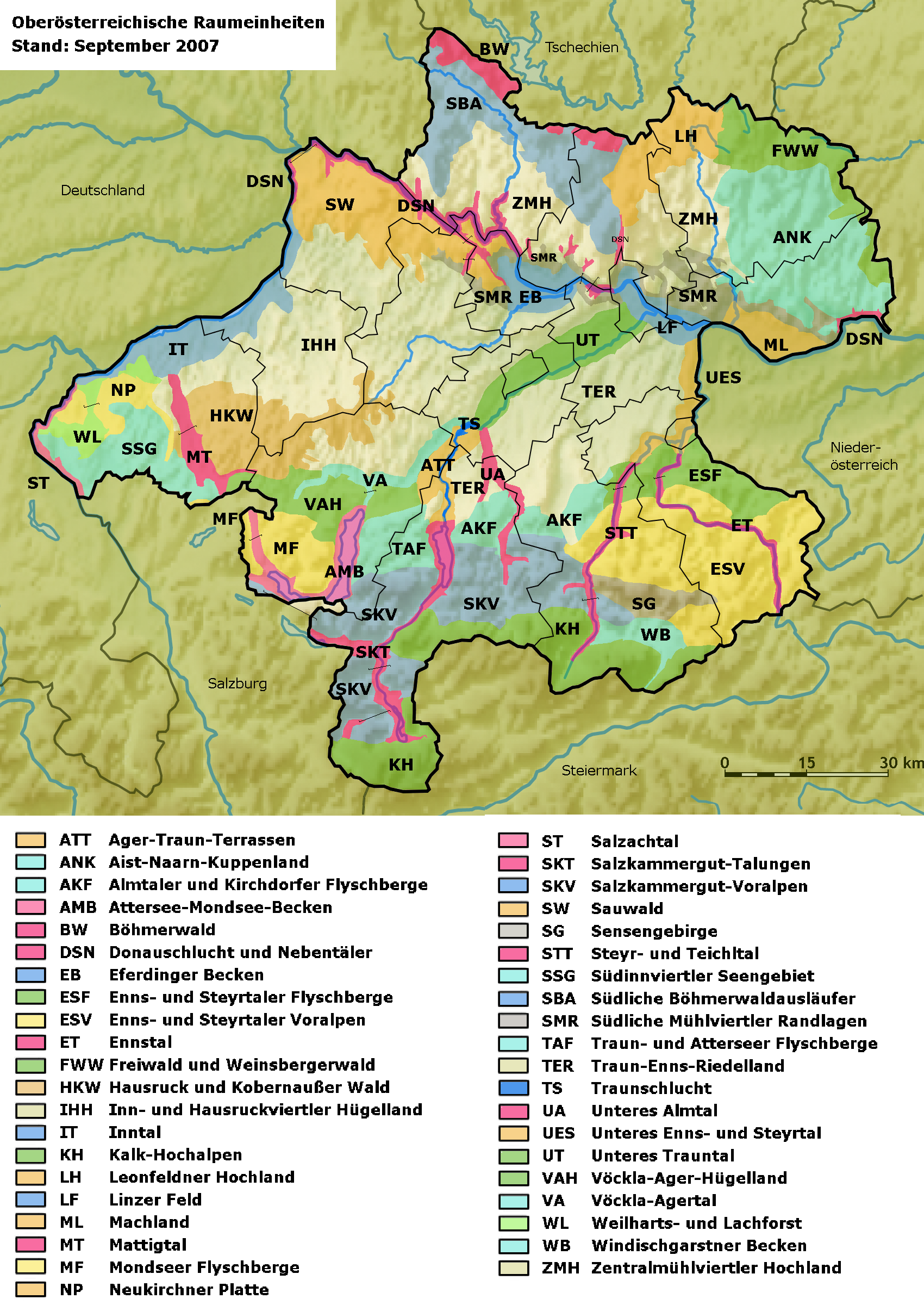
English: all 41 natural areas of Upper Austria
Deutsch: alle 41 OÖ Raumeinheiten |
| Date | |
| Source | Eigenes Werk (own work) nach Vorlage Land OÖ |
| Author | Hjanko, Lencer und NNW |
Grundkarte wurde erstellt von Lencer und NNW, Bundeslandgrenze und Raumeinheiten von Hjanko hinzugefügt
Licensing
edit
I, the copyright holder of this work, hereby publish it under the following licenses:

|
Permission is granted to copy, distribute and/or modify this document under the terms of the GNU Free Documentation License, Version 1.2 or any later version published by the Free Software Foundation; with no Invariant Sections, no Front-Cover Texts, and no Back-Cover Texts. A copy of the license is included in the section entitled GNU Free Documentation License. |
This file is licensed under the Creative Commons Attribution-Share Alike 3.0 Unported license.
- You are free:
- to share – to copy, distribute and transmit the work
- to remix – to adapt the work
- Under the following conditions:
- attribution – You must give appropriate credit, provide a link to the license, and indicate if changes were made. You may do so in any reasonable manner, but not in any way that suggests the licensor endorses you or your use.
- share alike – If you remix, transform, or build upon the material, you must distribute your contributions under the same or compatible license as the original.
You may select the license of your choice.
File history
Click on a date/time to view the file as it appeared at that time.
| Date/Time | Thumbnail | Dimensions | User | Comment | |
|---|---|---|---|---|---|
| current | 21:19, 24 October 2020 | | 1,700 × 2,400 (2.59 MB) | Kontrollstellekundl (talk | contribs) | hochkant mit vergrößerter Legende |
| 13:58, 1 October 2008 |  | 2,300 × 1,500 (2.19 MB) | Hjanko (talk | contribs) | {{Information |Description=kleinere Fehler ausgebessert |Source= |Date= |Author= |Permission= |other_versions= }} | |
| 13:29, 27 August 2008 |  | 2,300 × 1,500 (2.19 MB) | Hjanko (talk | contribs) | {{Information |Description=Kleine Verbesserungen (Gebiet außerhalb abgedunkelt, Legende geändert,... |Source=Originalversion: [http://www1.land-oberoesterreich.gv.at/natur/nala/asp/map_overview.asp Land OÖ] |Date= |Author= |Permission= |other_versions= | |
| 10:22, 21 August 2008 |  | 2,300 × 1,500 (2.27 MB) | Hjanko (talk | contribs) | {{Information |Description=Alle 41 Raumeinheiten und Benennung |Source= |Date= |Author= |Permission= |other_versions= }} | |
| 11:22, 20 August 2008 |  | 1,700 × 1,500 (2.14 MB) | Hjanko (talk | contribs) | {{Information |Description=weitere RE hinzugefügt |Source= |Date= |Author= |Permission= |other_versions= }} | |
| 06:56, 20 August 2008 |  | 1,700 × 1,500 (2.16 MB) | Hjanko (talk | contribs) | {{Information |Description=3 weitere Raumeinheiten hinzugefügt zur Veranschaulichung |Source= |Date= |Author= |Permission= |other_versions= }} | |
| 14:27, 19 August 2008 |  | 1,700 × 1,500 (2.19 MB) | Hjanko (talk | contribs) | {{Information |Description={{en|1=preview - don't use in article}} {{de|1=OÖ Raumeinheiten - 2. Vorversion}} |Source=Eigenes Werk (own work) |Author=Hjanko, Lencer und NNW |Date= |Perm |
You cannot overwrite this file.
File usage on Commons
The following 7 pages use this file:
File usage on other wikis
The following other wikis use this file:
- Usage on arz.wikipedia.org
- Usage on cs.wikipedia.org
- Usage on de.wikipedia.org
- Oberösterreich
- Eferdinger Becken
- Sauwald
- Almtal
- Machland (Raumeinheit)
- Zentralmühlviertler Hochland
- Raumeinheit (Oberösterreich)
- Freiwald und Weinsberger Wald
- Aist-Naarn-Kuppenland
- Südliche Mühlviertler Randlagen
- Donauschlucht und Nebentäler
- Ager-Traun-Terrassen
- Attersee-Mondsee-Becken
- Böhmerwald (Raumeinheit)
- Enns- und Steyrtaler Flyschberge
- Almtaler und Kirchdorfer Flyschberge
- Enns- und Steyrtaler Voralpen
- Oberösterreichisches Ennstal
- Leonfeldner Hochland
- Südliche Böhmerwaldausläufer
- Salzkammergut-Voralpen
- Mattigtal
- Traunschlucht
- Inn- und Hausruckviertler Hügelland
- Salzachtal (Raumeinheit)
- Traun-Enns-Riedelland
- Steyr- und Teichltal
- Wikipedia:Kartenwerkstatt/Archiv/2008-09
- Kalk-Hochalpen (Raumeinheit)
- Windischgarstner Becken
- Hausruck und Kobernaußerwald
- Vöckla-Agertal
- Neukirchner Platte
- Unteres Trauntal
- Unteres Enns- und Steyrtal
- Mondseer Flyschberge
- Weilharts- und Lachforst
- Südinnviertler Seengebiet
- Linzer Feld
- Salzkammergut-Talungen
- Traun- und Atterseer Flyschberge
- Vöckla-Ager-Hügelland
- Inntal (Raumeinheit)
- Benutzer Diskussion:RoBri/Archiv/2018
- Wikipedia:WikiProjekt Österreich/WD/Braunau am Inn
- Usage on en.wikipedia.org
View more global usage of this file.