File:Recife-Map1665-ForteCincoPontas.jpg
No higher resolution available.
Recife-Map1665-ForteCincoPontas.jpg (448 × 405 pixels, file size: 179 KB, MIME type: image/jpeg)
Captions
Captions
Add a one-line explanation of what this file represents
Summary
edit
| Description |
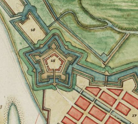
English: City of Recife (Brazil) in the 17th century showing the Fort of Cinco Pontas (labelled 28) |
||||
| Date | |||||
| Source | Vingboons Atlas (1665) | ||||
| Author | Unknown author | ||||
| Permission (Reusing this file) |
|
||||
Licensing
edit
|
This is a faithful photographic reproduction of a two-dimensional, public domain work of art. The work of art itself is in the public domain for the following reason:
The official position taken by the Wikimedia Foundation is that "faithful reproductions of two-dimensional public domain works of art are public domain".
This photographic reproduction is therefore also considered to be in the public domain in the United States. In other jurisdictions, re-use of this content may be restricted; see Reuse of PD-Art photographs for details. | ||||
File history
Click on a date/time to view the file as it appeared at that time.
| Date/Time | Thumbnail | Dimensions | User | Comment | |
|---|---|---|---|---|---|
| current | 17:06, 28 September 2023 | | 448 × 405 (179 KB) | Beao (talk | contribs) | Cropped 2 % horizontally, 12 % vertically using CropTool with lossless mode. Removed watermark. |
| 21:18, 28 September 2008 |  | 458 × 459 (189 KB) | Fulviusbsas (talk | contribs) | {{Information |Description={{en|1=City of Recife (Brazil) in the 17th century showing the Fort of Cinco Pontas (labelled 28)}} |Source=Vingboons Atlas (1665) |Author=unknown |Date=1665 |Permission={{PD-old}} |other_versions= }} <!--{{ImageUpload|full}}-- |
You cannot overwrite this file.
File usage on Commons
There are no pages that use this file.
File usage on other wikis
The following other wikis use this file:
- Usage on nl.wikipedia.org
- Usage on pt.wikipedia.org