File:Red Zone Map-de.svg

Size of this PNG preview of this SVG file: 800 × 537 pixels. Other resolutions: 320 × 215 pixels | 640 × 429 pixels | 1,024 × 687 pixels | 1,280 × 858 pixels | 2,560 × 1,717 pixels | 1,421 × 953 pixels.
Original file (SVG file, nominally 1,421 × 953 pixels, file size: 156 KB)
Captions
Captions
Add a one-line explanation of what this file represents
Summary edit
| Description |
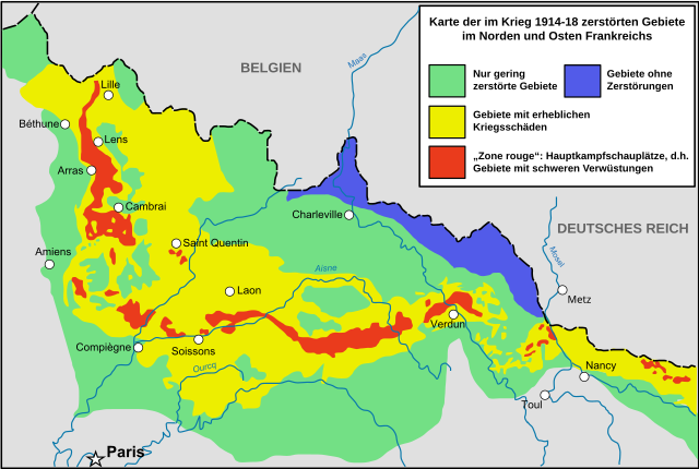
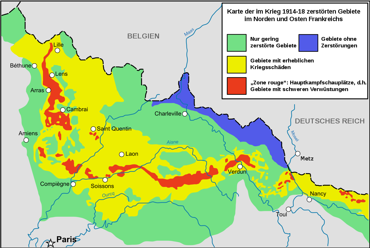
Deutsch: Als Zone rouge (Rote Zone) werden die Gebiete in Frankreich, die während des Ersten Weltkrieges am schwersten zerstört wurden, bezeichnet.
Français : La petite carte présente les bassins hydrographiques européens les plus concernés. Cette carte ne vaut que pour la France, mais la Belgique a également été très touchée. (d'après Guicherd, J., & Matriot, C. (1921). La terre des régions dévastées'. Journal d'Agriculture Pratique, 34, 154-6)
English: Zone rouge Map, describing in red zones completly destroyed by first world war. |
| Date | (UTC) |
| Source |
This file was derived from: Red Zone Map-fr.svg: |
| Author |
|
| Permission (Reusing this file) |
I, the copyright holder of this work, hereby publish it under the following license: This file is licensed under the Creative Commons Attribution-Share Alike 2.5 Generic license.
|
| Other versions |
|
| Validation/Created with | This vector image was created with Adobe Illustrator. |


| This is a retouched picture, which means that it has been digitally altered from its original version. Modifications: Tranduction allemand / German translation. The original can be viewed here: Red Zone Map-fr.svg:
|
Original upload log edit
This image is a derivative work of the following images:
- File:Red_Zone_Map-fr.svg licensed with Cc-by-sa-2.5
- 2008-09-16T15:37:20Z Tinodela 1421x953 (453623 Bytes) {{Information |Description= |Source= |Date= |Author= |Permission= |other_versions= }}
- 2008-09-16T15:36:20Z Tinodela 1421x953 (400493 Bytes) {{Information |Description=Zone rouge Map, describing in red zones completly destroyed by first world war / See also (french) [:http://fr.wikipedia.org/wiki/Zone_rouge_%28s%C3%A9quelles_de_guerre%29 French page of Wikipedia
Uploaded with derivativeFX
File history
Click on a date/time to view the file as it appeared at that time.
| Date/Time | Thumbnail | Dimensions | User | Comment | |
|---|---|---|---|---|---|
| current | 19:46, 20 September 2017 | | 1,421 × 953 (156 KB) | Furfur (talk | contribs) | corrected the font display |
| 23:31, 28 December 2015 |  | 1,421 × 953 (155 KB) | Furfur (talk | contribs) | SVG cleanup | |
| 17:01, 4 February 2012 |  | 1,421 × 953 (440 KB) | Furfur (talk | contribs) | == {{int:filedesc}} == {{Information |Description={{de|1=Als ''Zone rouge'' (Rote Zone) werden die Gebiete in Frankreich, die während des Ersten Welkrieges am schwersten zerstört wurden, beeichnet.}} {{fr|1=La petite carte présente les bassins hydrogra |
You cannot overwrite this file.
File usage on Commons
The following 3 pages use this file:
File usage on other wikis
The following other wikis use this file:
- Usage on de.wikipedia.org
- Usage on hu.wikipedia.org