File:Redmond Caves (28213189561).jpg

Original file (3,210 × 2,004 pixels, file size: 4.73 MB, MIME type: image/jpeg)
Captions
Captions
Summary edit
.jpg&action=edit§ion=1)
| Description |
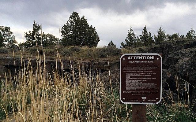
Photo by Greg Shine, BLM Redmond Caves is a site featuring five caves formed by volcanic flows of molten lava from the Newberry Caldera. Located inside the Redmond city limits, the site is managed by the Bureau of Land Management in partnership with the City of Redmond and is a unique site where visitors can learn about geology, wildlife, and past human use. The five caves were created from the collapse of a single lava tube. While some caving groups have given the individual caves names, most academic and archaeological groups refer to the caves by number. Cave 1: The largest cave opening, with the highest roof, located in the center of the site. Cave 2: A very small and shallow entrance tube that is present as a surface feature, located to the northwest of Cave 1 Cave 3: A long section of lava tube, with a southern and northern opening. Cave 4: A short section of lava tube with very low ceiling, located at the south end of the site, visible from Airport Avenue. Cave 5: A very small and shallow cave opening, located immediately east of Cave 4. The largest opening (Cave 1) enters a fairly deep and expansive cave, while Cave 3 has two openings joined by a narrow, but easily passable connection. Caves 1, 3, and 4 are accessible and have deep, sandy soils, with scattered boulders and ceiling blocks. The caves are a great place to explore today, and archaeological evidence and oral tradition point to human use of the caves for at least 6,000 years. Visitors are asked to respect the caves and the land surrounding them as a natural park, and to avoid artifact collecting, trash dumping, woodcutting or adding graffiti to the cave walls and entrances. The Prineville BLM will be managing the Redmond Caves area for foot traffic only with parking and an entrance on SW Airport Way. The area is flat and covered with scattered juniper trees, sagebrush and rabbitbrush. Visitors to the area can take a short, 3/4 - 1/2 mile hike around the parcel and explore the five caves. Redmond Caves have been listed as "Significant" under the Federal Caves Resources Protection Act due to their cultural, recreational, biological, and educational values. Given the unique historical, cultural, wildlife, and geological values of the site, visitors should practice "leave no trace ethics" when visiting the site. This 40-acre parcel is managed for education and interpretive use, and prohibits the following activities to help protect the caves: •Motorized and mechanized vehicles; •Campfires in the entire Redmond Caves Area, including the caves; •Overnight use, except under permit; •Placement of physical geocaches; •Paintball use; •All firearm discharge; •All rockhounding and collection of decorative stone; •Painting, marking, or otherwise defacing the caves and surrounding rocks; •Digging and excavating; •Use of fireworks or other pyrotechnic devices within the caves; •Dogs or other animals within the caves; •No smoking within the caves. These caves are preserved in their natural state; therefore, inherent risks exist that require precautions: •Always watch for rattlesnakes. •Leave word with someone stating what cave you will be visiting and an approximate return time. •Take three dependable sources of light. •Wear sturdy shoes that protect the ankle and have non-leather, non-skid, non-marking soles. •Gloves and kneepads may be necessary and/or useful in some caves. •Wear a helmet to protect against low ceilings. •Take someone with you when you enter a cave—don't go alone. Over the past fifty years, proposals for the use of the site have been creative and diverse. At the height of the Cold War, the caves were proposed for use as a fallout shelter in the event of an atomic attack; farmers from Madras looked at the site as a possible mushroom farm; and, the Deschutes County Historical Society even received a proposal to develop their offices in the caves themselves. In the mid-1990s, the Prineville BLM and City of Redmond formed a partnership to cooperatively manage the Redmond Caves site. This partnership was central to funding archaeological surveys and other site surveys to support management decisions for the area. In 2005, the BLM completed the Upper Deschutes Resource Management Plan, which provides objectives for managing the Redmond Cave area, including: •Protecting and maintaining the biologic, cultural, and geologic features of the caves; •Working with the City of Redmond to pursue the development of the area into a natural community park and to interpret the important features of the area; and •Providing recreation appropriate to management of the caves through the use of marked foot trails, designated parking and fencing. Redmond Caves is located on the northern end of the Newberry lava plain between the Crooked and Deschutes Rivers. As part of the high desert, the hot and dry character of the area influenced how native human populations and local wildlife used the caves and the surrounding lands. While the rivers represented access to vital resources, trails between the two rivers passed near the Redmond Caves site, and the caves likely provided a cool, but short-term, stop-over for travelers. Based on available information, this pattern of use seems to have persisted for the last 5000-7000 years. Formal archaeological excavations have provided a glimpse into the caves' use, with evidence of hunting and gathering through the remains of stone, bone, shell and textile artifacts. In 1941, Robert Heizer of the University of Oregon, conducted partial excavations inside the caves. His discoveries included items like obsidian and chert flakes, dart points, arrow points, a mano (a hand-held stone for grinding), a sandal fragment, and several pieces of animal bone. The scale of volcanic activity in Central Oregon is very large. The flows that created Redmond Caves came from Newberry Caldera over the past 2 million years. Newberry is a shield volcano located 35 miles away, and is the largest such volcano in the lower 48 states. Redmond Caves is just one portion of a system that stretches through eastern Bend, across BLM-managed lands east of State Highway 97 and into Redmond. A 1963 BLM mineral report mentions that local residents entered a cave on private property to the northeast of the site, crawled in a southwest direction, and exited one of the caves on the BLM parcel. The BLM has led several field trips to the caves with members and elders of the Confederated Tribes of the Warm Springs Reservation of Oregon (CTWSRO), Burns Paiute, and Klamath Tribes. Recollections of a few of the elders are as follows: •According to Delbert Frank, Sr. and Geraldine Jim of CTWSRO, the area around Redmond is referred to in the Sahaptin language as P'oosh P'oosh for the number of juniper trees in the area. •As young people, some of the elders recalled camping in the vicinity of the caves when their parents were working at nearby potato fields, while attending the rodeo, or traveling from one point to another off reservation. •Some elders remember a shallow layer of water on the cave floor and to keep them from potential danger, their parents told them that water babies and other malevolent spirits lived there. Some of the elders confided that despite their parent's warnings, they went into the caves anyway! In 2002, the BLM and the City of Redmond authorized the University of Oregon (Field School) to conduct a multi-year archeological project at Redmond Caves. This work included surveys of the entire 40-acre parcel, with the discovery of numerous prehistoric sites and a few historic period refuse scatters. Over the course of several seasons of work, archeological excavation was done inside the caves. Cultural items identified and recorded included: •Projectile points (arrowheads); •Fresh water and marine shells (Olivella and Dentalium); •Bifaces and edge-modified flakes; •Cordage, shell, bone and stone disc beads, and bone needles, awls, and hooks; •Ochre; •Tools such as an Elkhorn digging stick handle, a milling stone, and stone mortar; •Large amounts of naturally and culturally deposited animal bones (the later resulting from food consumption by early human inhabitants); •Obsidian from the site was analyzed through X-ray fluorescence, identifying where the stone originated. Based on the testing, obsidian tools at the site came from the following locations: Obsidian Cliffs - 33 miles McKay Butte - 37 miles Newberry Volcano - 36 miles Spodue Mountain - 114 miles Quartz Mountain - 45 miles The Field School sent a sagebrush sandal fragment found in Redmond Caves in the 1940s for radiocarbon dating, which showed that it is roughly 1700 to 1900 years old. The sandal is a multiple warp type sandal, which is one of styles of sandal with the widest geographic and temporal distribution in the Northern Great Basin. In 1938, J.M. Valentine collected a holotype (the individual organism used in naming and describing a new species and usually preserved afterward) of the Charlotte's False Scorpion (Parobisium charlotteae) from Redmond Caves. This false scorpion is in the family Neobisiidae, which contains over 200 named species of false scorpions. Pseudoscorpions are very small (usually less than 4 millimeters) and generally beneficial. Their prey includes moth larvae, carpet beetle larvae, booklice, mites, and small flies. |
| Date | |
| Source | Redmond Caves |
| Author | Bureau of Land Management Oregon and Washington from Portland, America |
| Camera location | | View this and other nearby images on: OpenStreetMap |
|---|
.jpg¶ms=044.249517_N_-121.179214_E_globe:Earth_type:camera_alt:928.15556_source:exif_heading:84.00&language=en)
Licensing edit
.jpg&action=edit§ion=2)
- You are free:
- to share – to copy, distribute and transmit the work
- to remix – to adapt the work
- Under the following conditions:
- attribution – You must give appropriate credit, provide a link to the license, and indicate if changes were made. You may do so in any reasonable manner, but not in any way that suggests the licensor endorses you or your use.
| This image was originally posted to Flickr by BLMOregon at https://flickr.com/photos/50169152@N06/28213189561 (archive). It was reviewed on 14 May 2018 by FlickreviewR 2 and was confirmed to be licensed under the terms of the cc-by-2.0. |
| This image is a work of a Bureau of Land Management* employee, taken or made as part of that person's official duties. As a work of the U.S. federal government, the image is in the public domain in the United States. *or predecessor organization |
| This image is a work of a Bureau of Land Management* employee, taken or made as part of that person's official duties. As a work of the U.S. federal government, the image is in the public domain in the United States. *or predecessor organization |
File history
Click on a date/time to view the file as it appeared at that time.
| Date/Time | Thumbnail | Dimensions | User | Comment | |
|---|---|---|---|---|---|
| current | 00:17, 14 May 2018 | | 3,210 × 2,004 (4.73 MB) | OceanAtoll (talk | contribs) | Transferred from Flickr via #flickr2commons |
You cannot overwrite this file.
File usage on Commons
There are no pages that use this file.
.jpg&oldid=475392796)