File:Region de Aysen-Rios y Ciudades(png).png

Size of this preview: 347 × 599 pixels. Other resolutions: 139 × 240 pixels | 278 × 480 pixels | 778 × 1,343 pixels.
Original file (778 × 1,343 pixels, file size: 789 KB, MIME type: image/png)
Captions
Captions
Add a one-line explanation of what this file represents
Summary
edit.png&action=edit§ion=1)
| Description |
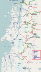
Español: Mapa de Aisen obtenido de Openstreetmap.org, con Carretera Austral y algunos ríos. |
| Date | |
| Source |
This file was derived from: Region de Aysen-Rios y Ciudades.svg:  |
| Author |
|
.png)
| This is a retouched picture, which means that it has been digitally altered from its original version. Modifications: convert svg to png. The original can be viewed here: Region de Aysen-Rios y Ciudades.svg:
|
Licensing
edit.png&action=edit§ion=2)
I, the copyright holder of this work, hereby publish it under the following license:
This file is licensed under the Creative Commons Attribution-Share Alike 2.5 Generic license.
- You are free:
- to share – to copy, distribute and transmit the work
- to remix – to adapt the work
- Under the following conditions:
- attribution – You must give appropriate credit, provide a link to the license, and indicate if changes were made. You may do so in any reasonable manner, but not in any way that suggests the licensor endorses you or your use.
- share alike – If you remix, transform, or build upon the material, you must distribute your contributions under the same or compatible license as the original.
Original upload log
edit.png&action=edit§ion=3)
This image is a derivative work of the following images:
- File:Region_de_Aysen-Rios_y_Ciudades.svg licensed with Cc-by-sa-2.5
- 2013-08-18T23:07:27Z Createaccount 1000x1727 (1403291 Bytes) == {{int:filedesc}} == {{Information |Description={{es|1=Mapa de Aisen obtenido de Openstreetmap.org, con Carretera Austral y algunos ríos.}} |date=2013-08-17 16:07:56 |Source={{Derived from|Carretera_austral_de_Chile.svg|di
Uploaded with derivativeFX
File history
Click on a date/time to view the file as it appeared at that time.
| Date/Time | Thumbnail | Dimensions | User | Comment | |
|---|---|---|---|---|---|
| current | 22:23, 19 August 2013 | | 778 × 1,343 (789 KB) | Keysanger (talk | contribs) | added: Simpson, Pascua, Cochrane, Ibañez, Blanco, Moro, Caceres, Cisnes |
| 23:10, 18 August 2013 |  | 778 × 1,343 (777 KB) | Keysanger (talk | contribs) | == {{int:filedesc}} == {{Information |Description={{es|1=Mapa de Aisen obtenido de Openstreetmap.org, con Carretera Austral y algunos ríos.}} |date=2013-08-17 16:07:56 |Source={{Derived from|Region_de_Aysen-Rios_y_Ciudades.svg|display=50}} |Date=2013-... |
You cannot overwrite this file.
File usage on Commons
The following page uses this file:
File usage on other wikis
The following other wikis use this file:
- Usage on ar.wikipedia.org
- Usage on arz.wikipedia.org
- Usage on br.wikipedia.org
- Usage on de.wikipedia.org
- Usage on en.wikipedia.org
- San Quintín Glacier
- Northern Patagonian Ice Field
- General Carrera Lake
- O'Higgins/San Martín Lake
- Southern Patagonian Ice Field
- San Rafael Glacier
- Baker River (Chile)
- Baker Channel
- Pascua River
- Cochrane/Pueyrredón Lake
- Presidente Ríos Lake
- San Rafael Lake
- Ibáñez River
- Cochrane River
- O'Higgins Glacier
- Jorge Montt Glacier
- Nef Glacier
- Bernardo Glacier
- Aysén River
- Template:Aysén Region rivers and lakes
- Cisnes River
- Bertrand Lake
- Simpson River
- Puyuhuapi Channel
- Yulton Lake
- Colonia Glacier
- Colonia River
- Mayer River
- Nef River
- Palena River
- Steffen Glacier
- Exploradores Glacier
- Chacabuco River
- List of rivers of the Aysén Region
- Figueroa River
- San Tadeo River
- Mañihuales River
- Wager Island
- Usage on es.wikipedia.org
- Usage on fr.wikipedia.org
- Usage on incubator.wikimedia.org
- Usage on it.wikipedia.org
- Usage on ja.wikipedia.org
View more global usage of this file.
.png)
.png&oldid=691599168)