File:Reichsstadt Biberach 1725.png

Size of this preview: 520 × 599 pixels. Other resolutions: 208 × 240 pixels | 417 × 480 pixels | 667 × 768 pixels | 1,134 × 1,306 pixels.
Original file (1,134 × 1,306 pixels, file size: 2.97 MB, MIME type: image/png)
Captions
Captions
Add a one-line explanation of what this file represents
Summary edit
| Description |
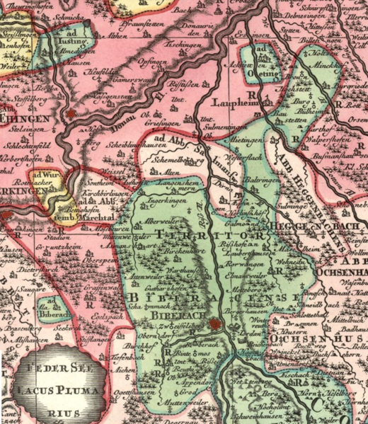
English: Detail cropped out of an early 18th century map showing the territory of the Free Imperial City of Biberach ("Territor Bibberacense", in the darker green), now Biberach an der Riss. Biberach's immediate neighbours were mostly self-ruling imperial abbeys (in light pink), such as Marchthal, Ochsenhausen and Heggbach. The letter 'R' distributed here and there on the map indicates the location of an estate belonging to an imperial knight (Reichsritter), who was subordinate only to the emperor and therefore independent. Cropped out of map five of a nine-map series centered on the Circle of Swabia titled Suevia Universa by Matthäus Seutter and based on information supplied by Jacques de Michal. Published c 1725-1727. |
| Date | circa 1725 |
| Source | Moll's map collectiton |
| Author | Matthäus Seutter-Jacques de Michal |
Licensing edit
|
This work is in the public domain in its country of origin and other countries and areas where the copyright term is the author's life plus 100 years or fewer. | |
| This file has been identified as being free of known restrictions under copyright law, including all related and neighboring rights. | |
File history
Click on a date/time to view the file as it appeared at that time.
| Date/Time | Thumbnail | Dimensions | User | Comment | |
|---|---|---|---|---|---|
| current | 14:57, 29 August 2018 | | 1,134 × 1,306 (2.97 MB) | Lubiesque (talk | contribs) | Includes missing part |
| 23:06, 25 August 2018 |  | 1,600 × 1,508 (4.46 MB) | Lubiesque (talk | contribs) | User created page with UploadWizard |
You cannot overwrite this file.
File usage on Commons
There are no pages that use this file.
File usage on other wikis
The following other wikis use this file:
- Usage on de.wikipedia.org