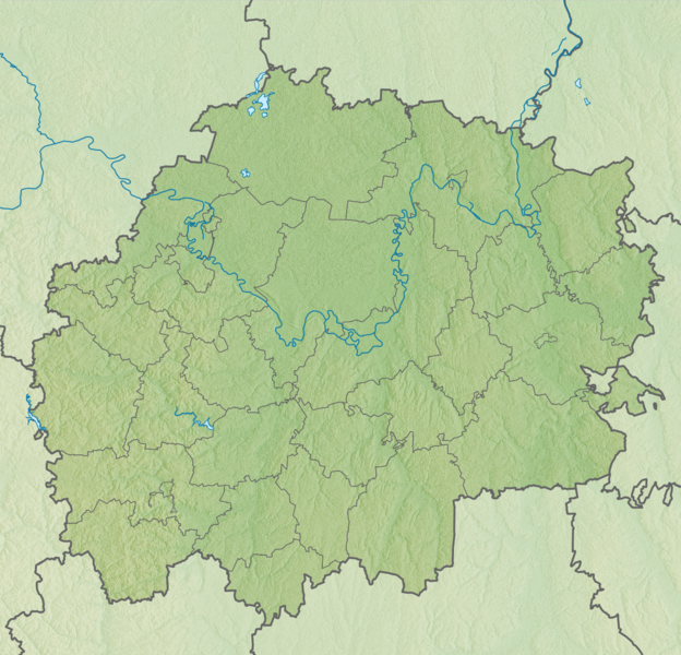
File:Relief Map of Ryazan Oblast.png

Size of this preview: 624 × 600 pixels. Other resolutions: 250 × 240 pixels | 500 × 480 pixels | 799 × 768 pixels | 1,200 × 1,153 pixels.
Original file (1,200 × 1,153 pixels, file size: 2.49 MB, MIME type: image/png)
Captions
Captions
Add a one-line explanation of what this file represents
Summary edit
| Description |
Русский: Физическая карта Рязанской области
|top = 55.6 |bottom = 53.2 |left = 38.5 |right = 42.8 |
| Date | |
| Source | |
| Author | Виктор В |
| Other versions |
[] |


Licensing edit
| I, the copyright holder of this work, release this work into the public domain. This applies worldwide. In some countries this may not be legally possible; if so: I grant anyone the right to use this work for any purpose, without any conditions, unless such conditions are required by law. |
File history
Click on a date/time to view the file as it appeared at that time.
| Date/Time | Thumbnail | Dimensions | User | Comment | |
|---|---|---|---|---|---|
| current | 16:17, 30 August 2010 | | 1,200 × 1,153 (2.49 MB) | Виктор В (talk | contribs) | == {{int:filedesc}} == {{Information |Description={{ru|1=Физическая карта Рязанской области *Проекция — равноугольная. *Стандартная параллель — 54°30′00″с.ш. *Параме� |
You cannot overwrite this file.
File usage on Commons
The following 3 pages use this file:
File usage on other wikis
The following other wikis use this file:
- Usage on ar.wikipedia.org
- Usage on ba.wikipedia.org
- Usage on be.wikipedia.org
- Usage on bg.wikipedia.org
- Usage on ceb.wikipedia.org
- Usage on ce.wikipedia.org
- Usage on cs.wikipedia.org
- Usage on cv.wikipedia.org
- Usage on da.wikipedia.org
- Usage on de.wikipedia.org
- Usage on el.wikipedia.org
- Usage on en.wikipedia.org
- Usage on eo.wikipedia.org
- Usage on es.wikipedia.org
View more global usage of this file.