File:Relief Map of Tver Oblast.png
Size of this preview: 766 × 600 pixels. Other resolutions: 307 × 240 pixels | 613 × 480 pixels | 861 × 674 pixels.
Original file (861 × 674 pixels, file size: 784 KB, MIME type: image/png)
Captions
Captions
Add a one-line explanation of what this file represents
Summary edit
| Description |
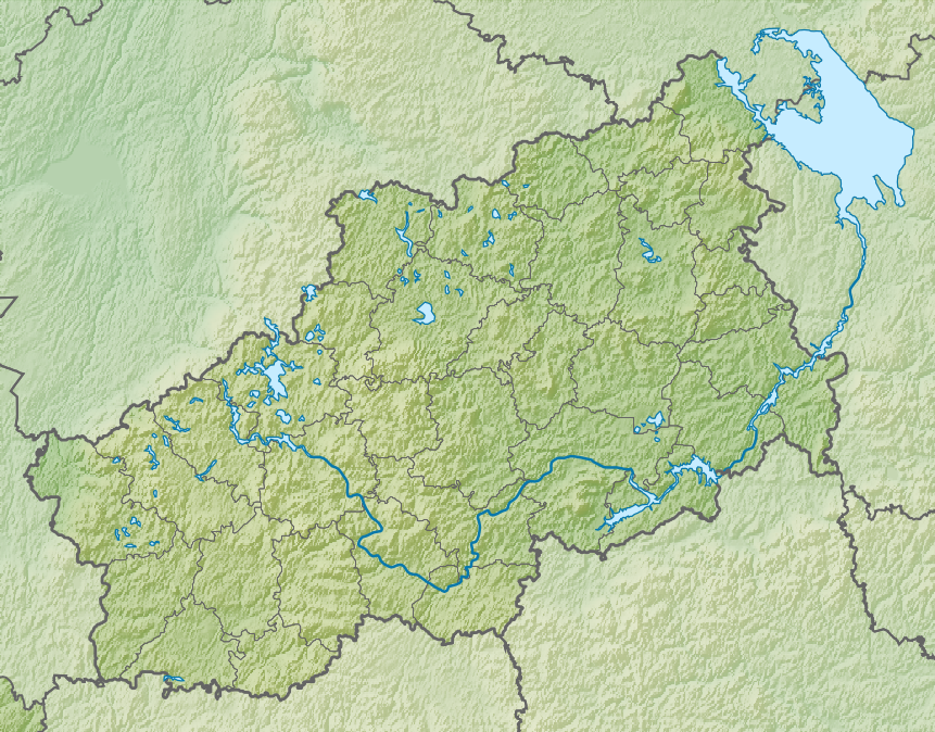
Русский: Физическая карта Тверской области, Россия.
|
| Date | |
| Source |
|
| Author | Nzeemin |
| Other versions |
|

Licensing edit
I, the copyright holder of this work, hereby publish it under the following license:
This file is licensed under the Creative Commons Attribution-Share Alike 3.0 Unported license.
- You are free:
- to share – to copy, distribute and transmit the work
- to remix – to adapt the work
- Under the following conditions:
- attribution – You must give appropriate credit, provide a link to the license, and indicate if changes were made. You may do so in any reasonable manner, but not in any way that suggests the licensor endorses you or your use.
- share alike – If you remix, transform, or build upon the material, you must distribute your contributions under the same or compatible license as the original.
File history
Click on a date/time to view the file as it appeared at that time.
| Date/Time | Thumbnail | Dimensions | User | Comment | |
|---|---|---|---|---|---|
| current | 18:59, 29 March 2012 | | 861 × 674 (784 KB) | Nzeemin (talk | contribs) | plus mask |
| 16:27, 8 March 2012 |  | 861 × 674 (805 KB) | Nzeemin (talk | contribs) | updated outline layer | |
| 18:03, 7 March 2012 |  | 861 × 674 (798 KB) | Nzeemin (talk | contribs) |
You cannot overwrite this file.
File usage on Commons
There are no pages that use this file.
File usage on other wikis
The following other wikis use this file:
- Usage on ba.wikipedia.org
- Кесе Шешма
- Белейка
- Бойня (йылға)
- Оло Дубенка
- Ворчала
- Дарня
- Дедуша
- Дуниловка
- Дыхла
- Жилинка
- Итомля
- Кокша (Волга ҡушылдығы)
- Кострина (Песочня ҡушылдығы)
- Коча (Волга ҡушылдығы)
- Коча (йылға)
- Кесе Дубенка
- Кесе Итомля
- Кесе Лоча
- Мерзкая (Бойня ҡушылдығы)
- Млинга
- Мшена
- Ночна (Тудовка ҡушылдығы)
- Ночная (Тудовка ҡушылдығы)
- Оболонка
- Орча
- Осницкая
- Песочня (Волга ҡушылдығы)
- Песочня (Пырошня ҡушылдығы)
- Пырошня
- Ракитня (Волга ҡушылдығы)
- Рясинка
- Рясня (Оло Коша ҡушылдығы)
- Сватолиха
- Сиговка
- Сижина
- Сишка
- Скоковка
- Слатенка
- Солодомня
- Сорога (йылға)
- Тихвина
- Трясня
- Трясянка
- Ускройня
- Халынка (Волга ҡушылдығы)
- Хитка
- Хмелевочка
- Якшина (Дедуша ҡушылдығы)
- Ясменка (Итомля ҡушылдығы)
- Ҡалып:ПозКарта Рәсәй Тверь өлкәһе
View more global usage of this file.