File:Rempart gallo-romain d'Évreux 2.JPG
Original file (4,608 × 3,456 pixels, file size: 3.25 MB, MIME type: image/jpeg)
Captions
Captions
![]() |
This building is en partie classé, en partie inscrit au titre des monuments historiques de la France. It is indexed in the base Mérimée, a database of architectural heritage maintained by the French Ministry of Culture, under the reference PA00099407
![]() brezhoneg ∙ català ∙ Deutsch ∙ English ∙ español ∙ Esperanto ∙ euskara ∙ français ∙ italiano ∙ magyar ∙ Nederlands ∙ português do Brasil ∙ português ∙ română ∙ sicilianu ∙ slovenščina ∙ suomi ∙ svenska ∙ Ελληνικά ∙ беларуская (тарашкевіца) ∙ македонски ∙ русский ∙ українська ∙ বাংলা ∙ +/− |
![]() |
Summary
editCamera location | 49° 01′ 31.97″ N, 1° 09′ 08.88″ E ![]() | View this and other nearby images on: OpenStreetMap | ![]() |
---|
DescriptionRempart gallo-romain d'Évreux 2.JPG |
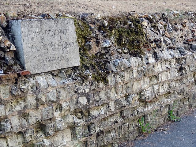
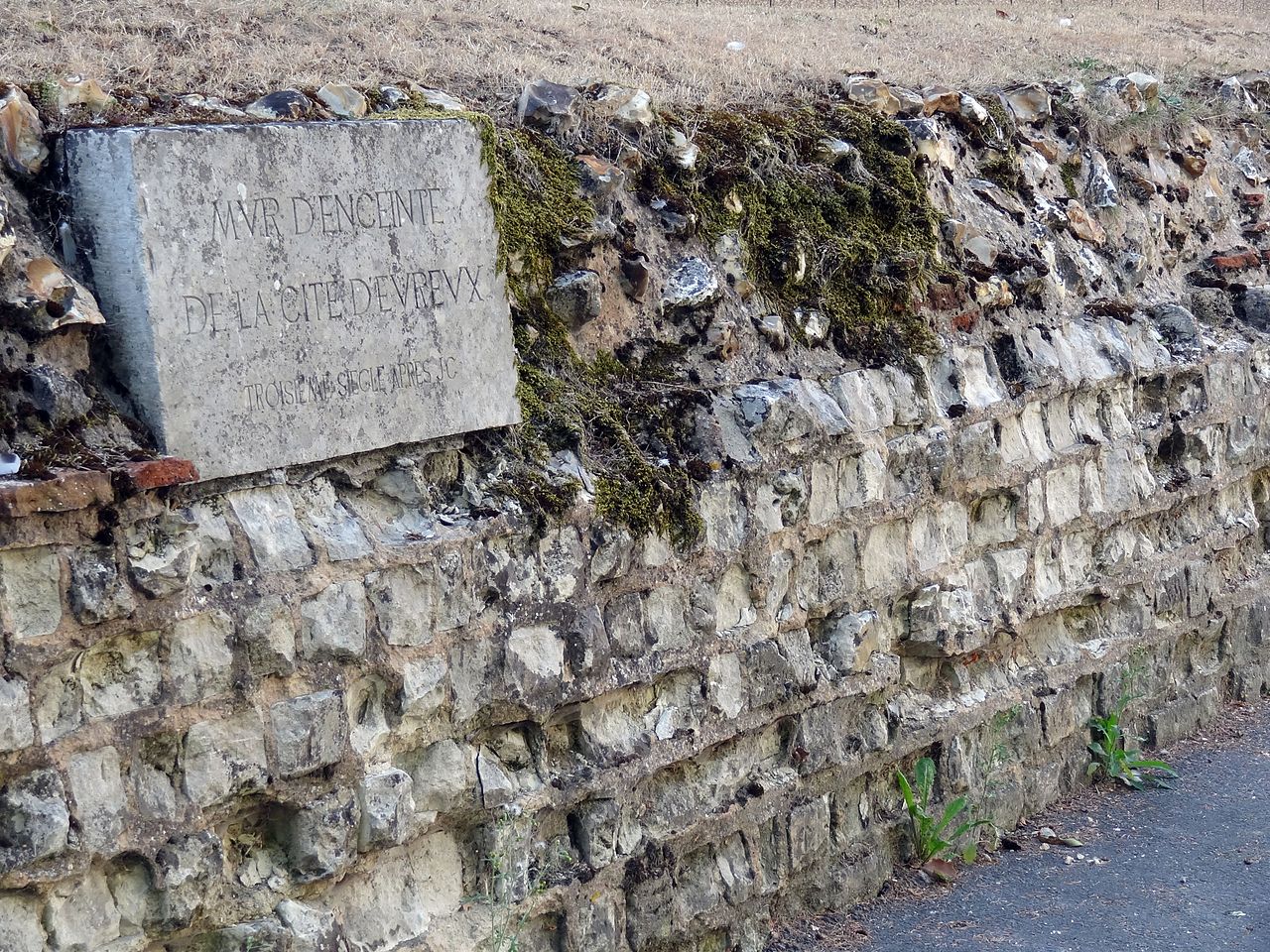
Français : Restes du rempart gallo-romain d'Évreux, allée des soupirs, avec une plaque indiquant : "mur d'enceinte de la cité d’Évreux - troisième siècle après JC" |
Date | |
Source | Own work |
Author | X-Javier |
Licensing
edit![w:en:Creative Commons](https://upload.wikimedia.org/wikipedia/commons/thumb/7/79/CC_some_rights_reserved.svg/90px-CC_some_rights_reserved.svg.png)
![attribution](https://upload.wikimedia.org/wikipedia/commons/thumb/1/11/Cc-by_new_white.svg/24px-Cc-by_new_white.svg.png)
![share alike](https://upload.wikimedia.org/wikipedia/commons/thumb/d/df/Cc-sa_white.svg/24px-Cc-sa_white.svg.png)
- You are free:
- to share – to copy, distribute and transmit the work
- to remix – to adapt the work
- Under the following conditions:
- attribution – You must give appropriate credit, provide a link to the license, and indicate if changes were made. You may do so in any reasonable manner, but not in any way that suggests the licensor endorses you or your use.
- share alike – If you remix, transform, or build upon the material, you must distribute your contributions under the same or compatible license as the original.
![]() |
This image was uploaded as part of Wiki Loves Monuments 2012.
Afrikaans ∙ Alemannisch ∙ azərbaycanca ∙ Bahasa Indonesia ∙ Bahasa Melayu ∙ Bikol Central ∙ bosanski ∙ brezhoneg ∙ català ∙ čeština ∙ Cymraeg ∙ dansk ∙ davvisámegiella ∙ Deutsch ∙ eesti ∙ English ∙ español ∙ Esperanto ∙ euskara ∙ français ∙ Frysk ∙ Gaeilge ∙ galego ∙ hrvatski ∙ Ido ∙ italiano ∙ latviešu ∙ Lëtzebuergesch ∙ Malagasy ∙ magyar ∙ Malti ∙ Nederlands ∙ norsk ∙ norsk nynorsk ∙ norsk bokmål ∙ polski ∙ português ∙ português do Brasil ∙ română ∙ shqip ∙ sicilianu ∙ slovenčina ∙ slovenščina ∙ suomi ∙ svenska ∙ Tagalog ∙ Türkçe ∙ Yorùbá ∙ Zazaki ∙ Ελληνικά ∙ беларуская ∙ беларуская (тарашкевіца) ∙ български ∙ кыргызча ∙ македонски ∙ русский ∙ српски / srpski ∙ українська ∙ ქართული ∙ հայերեն ∙ नेपाली ∙ हिन्दी ∙ বাংলা ∙ മലയാളം ∙ ไทย ∙ 한국어 ∙ +/− |
![]() |
File history
Click on a date/time to view the file as it appeared at that time.
Date/Time | Thumbnail | Dimensions | User | Comment | |
---|---|---|---|---|---|
current | 15:42, 15 September 2012 | 4,608 × 3,456 (3.25 MB) | X-Javier (talk | contribs) | User created page with UploadWizard |
You cannot overwrite this file.
File usage on Commons
The following page uses this file:
File usage on other wikis
The following other wikis use this file:
- Usage on fr.wikipedia.org
Metadata
This file contains additional information such as Exif metadata which may have been added by the digital camera, scanner, or software program used to create or digitize it. If the file has been modified from its original state, some details such as the timestamp may not fully reflect those of the original file. The timestamp is only as accurate as the clock in the camera, and it may be completely wrong.
Camera manufacturer | SONY |
---|---|
Camera model | DSC-HX9V |
Exposure time | 1/80 sec (0.0125) |
F-number | f/4.5 |
ISO speed rating | 125 |
Date and time of data generation | 16:11, 9 September 2012 |
Lens focal length | 14.23 mm |
Latitude | 49° 1′ 31.53″ N |
Longitude | 1° 9′ 7.19″ E |
Altitude | 53.631 meters above sea level |
Orientation | Normal |
Horizontal resolution | 72 dpi |
Vertical resolution | 72 dpi |
File change date and time | 16:11, 9 September 2012 |
Y and C positioning | Co-sited |
Exposure Program | Normal program |
Exif version | 2.3 |
Date and time of digitizing | 16:11, 9 September 2012 |
Meaning of each component |
|
Image compression mode | 3 |
APEX brightness | 6.05625 |
APEX exposure bias | 0 |
Maximum land aperture | 3.4375 APEX (f/3.29) |
Metering mode | Pattern |
Light source | Unknown |
Flash | Flash did not fire, compulsory flash suppression |
Supported Flashpix version | 1 |
Color space | sRGB |
File source | Digital still camera |
Scene type | A directly photographed image |
Custom image processing | Normal process |
Exposure mode | Auto exposure |
White balance | Auto white balance |
Digital zoom ratio | 1 |
Scene capture type | Standard |
Contrast | Normal |
Saturation | Normal |
Sharpness | Normal |
GPS time (atomic clock) | 14:11 |
Receiver status | Measurement in progress |
Measurement mode | 3-dimensional measurement |
Measurement precision | Poor (2.3749) |
Speed unit | Kilometers per hour |
Speed of GPS receiver | 5.493 |
Reference for direction of movement | True direction |
Direction of movement | 186.42 |
Reference for direction of image | Magnetic direction |
Direction of image | 289.25 |
Geodetic survey data used | WGS-84 |
GPS date | 9 September 2012 |
GPS differential correction | 0 |
GPS tag version | 0.0.3.2 |