File:República do Congo (RDC), Uganda.jpg

Original file (5,163 × 2,910 pixels, file size: 8.43 MB, MIME type: image/jpeg)
Captions
Captions
Summary
edit,_Uganda.jpg&action=edit§ion=1)
| Description |
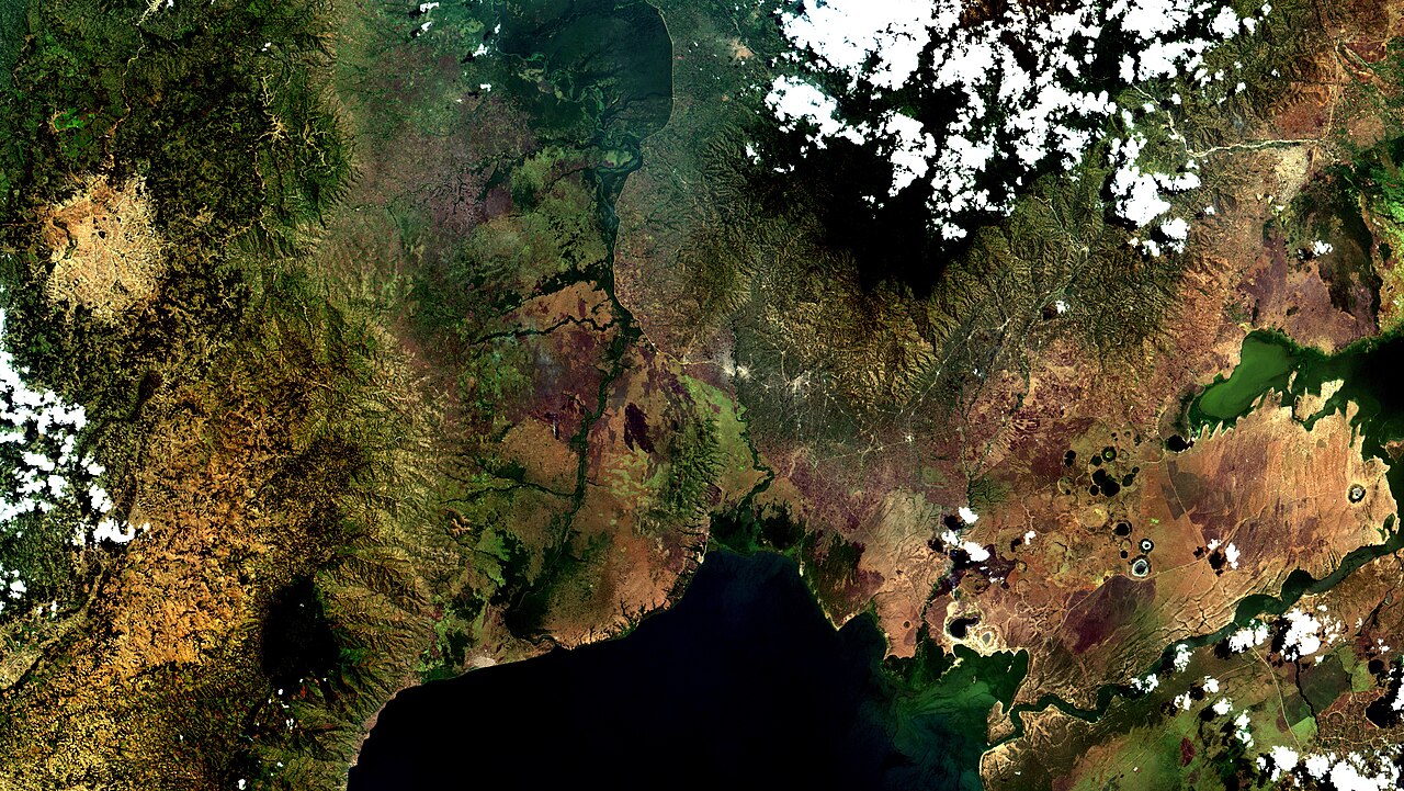
English: Fronteira República Democrática do Congo (RDC), Uganda, onde ocorre grave surto de ebola. A fronteira é delimitada pelo Rio Tako, várzea em verde escuro no alto à esq.; afluente do Lago Eduardo, em azul escuro, embaixo à esq.. Áreas urbanas aparecem em branco (tons tênues), conectadas por estradas, linhas brancas. Na fronteira estão Kyasenda 2, RDC e Mpondwe, Uganda, próximas a Beni e Butembo, grandes cidades com mais casos registrados até agora. Mais à direita, no pé das Montanhas Rwenzori, está Bwera, onde os Médicos Sem Fronteiras @msf_brasil (MSF) instalaram uma tenda de isolamento, para o caso do surto passar a fronteira / Democratic Republic of Congo (DRC), Uganda border, where a serious ebola outbreak is happening now. Border is marked by Tako River lowlands, in dark green, at upper left, a Lake Edward, in dark blue at lower left, tributary. Urban areas in white (soft color), connected by white lines, wich are roads. Kyasenda 2, RDC, and Mpondwe, Uganda, near Beni and Butembo, large cities with most cases up to now, are beside the border. To their right, at Rwenzori Mountain foot, is Bwera, where @doctorswithoutborders set up an isolation tent, in case outbreak jumps the border.
+ info 1) Mapa e estatísticas da OMS em tempo real do surto atual na RDC 2) MSF DRC 2018 Ebola outbreak crisis update October 2018 3) Ebola virus disease – Democratic Republic of the Congo WHO Disease outbreak news 18 October 2018
Imagem / Image CBERS MUX República Democrática do Congo (RDC), Uganda Coordenadas do centro da imagem / Image center: 0°01'24.2"S 29°47'37.7"E Data / Date: 14-08-2018 / 2018-14-08 RGB 765 (cor verdadeira / true color) Cena / Scene: 081 / 100 Autor / Author: Oton Barros (DSR/OBT/INPE) Imagem em HD / HD Image Visite-nos / Visit us: www.dsr.inpe.br |
| Date | |
| Source | https://www.flickr.com/photos/153282474@N02/44967781465/ |
| Author | Coordenação-Geral de Observação da Terra/INPE |
Licensing
edit,_Uganda.jpg&action=edit§ion=2)
- You are free:
- to share – to copy, distribute and transmit the work
- to remix – to adapt the work
- Under the following conditions:
- attribution – You must give appropriate credit, provide a link to the license, and indicate if changes were made. You may do so in any reasonable manner, but not in any way that suggests the licensor endorses you or your use.
- share alike – If you remix, transform, or build upon the material, you must distribute your contributions under the same or compatible license as the original.
| This image was originally posted to Flickr by Coordenação-Geral de Observação da Terra/INPE at https://flickr.com/photos/153282474@N02/44967781465. It was reviewed on 9 April 2020 by FlickreviewR 2 and was confirmed to be licensed under the terms of the cc-by-sa-2.0. |
File history
Click on a date/time to view the file as it appeared at that time.
| Date/Time | Thumbnail | Dimensions | User | Comment | |
|---|---|---|---|---|---|
| current | 10:14, 9 April 2020 | | 5,163 × 2,910 (8.43 MB) | Jo-Jo Eumerus (talk | contribs) | Uploaded a work by Coordenação-Geral de Observação da Terra/INPE from https://www.flickr.com/photos/153282474@N02/44967781465/ with UploadWizard |
You cannot overwrite this file.
File usage on Commons
The following 3 pages use this file:
,_Uganda_(44967781465).jpg&redirect=no)
,_Uganda.jpg&oldid=859248121)