File:Reproduction map of Ireland by Pieter van den Keere 1591.jpeg
Size of this preview: 800 × 524 pixels. Other resolutions: 320 × 210 pixels | 640 × 419 pixels | 1,024 × 671 pixels | 1,280 × 839 pixels | 2,560 × 1,677 pixels | 3,660 × 2,398 pixels.
Original file (3,660 × 2,398 pixels, file size: 3.85 MB, MIME type: image/jpeg)
Captions
Captions
Add a one-line explanation of what this file represents
Summary edit
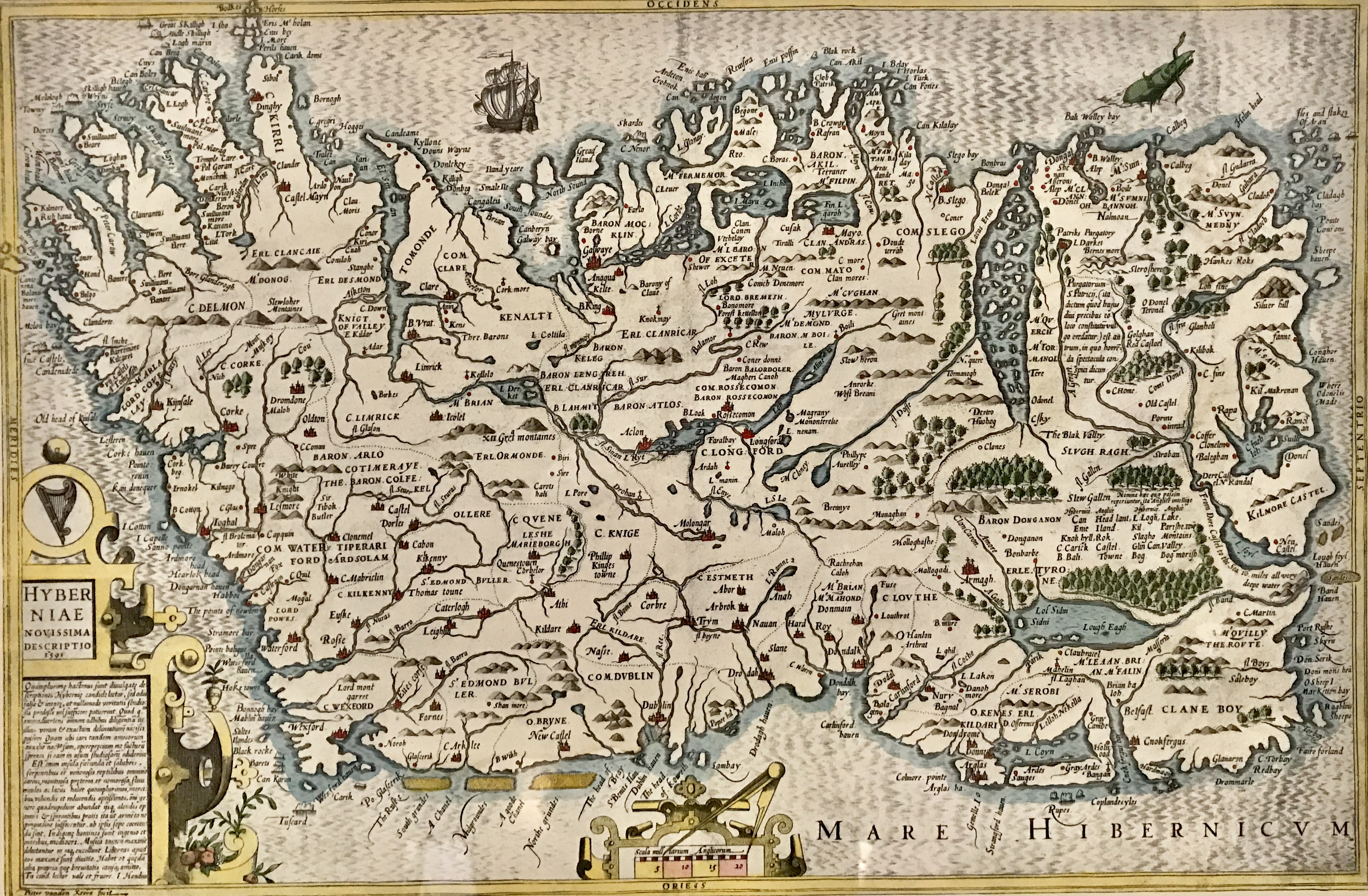
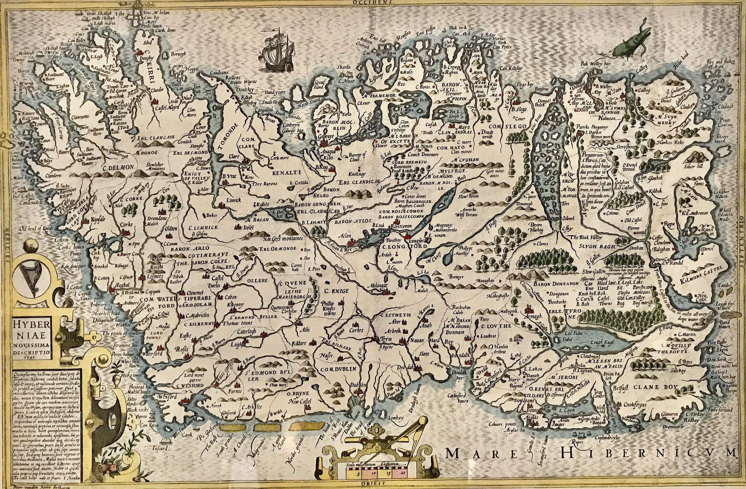
| Map of Ireland 1591
|
|||||||||||||||||||||||||||||||||||||||||||||
|---|---|---|---|---|---|---|---|---|---|---|---|---|---|---|---|---|---|---|---|---|---|---|---|---|---|---|---|---|---|---|---|---|---|---|---|---|---|---|---|---|---|---|---|---|---|
| Artist |
|
 | |||||||||||||||||||||||||||||||||||||||||||
| Title |
Latin: Hiberniæ Novissima Descriptio 1591 Map of Ireland 1591 |
||||||||||||||||||||||||||||||||||||||||||||
| Object type |
map edition / engraved map |
||||||||||||||||||||||||||||||||||||||||||||
| Description |
English: Reproduction of the Map of Ireland by Pieter van den Keere, Linen Hall library, Belfast. |
||||||||||||||||||||||||||||||||||||||||||||
| Inscriptions |
Pieter vanden Keere fecit
|
||||||||||||||||||||||||||||||||||||||||||||
| References |
Engraving in England in the Sixteenth & Seventeenth Centuries: a descriptive catalogue with introductions: Part 1: The Tudor Period |
||||||||||||||||||||||||||||||||||||||||||||
| Source/Photographer | Drummond Reid Antiques Image | ||||||||||||||||||||||||||||||||||||||||||||
Licensing edit
|
This is a faithful photographic reproduction of a two-dimensional, public domain work of art. The work of art itself is in the public domain for the following reason:
The official position taken by the Wikimedia Foundation is that "faithful reproductions of two-dimensional public domain works of art are public domain".
This photographic reproduction is therefore also considered to be in the public domain in the United States. In other jurisdictions, re-use of this content may be restricted; see Reuse of PD-Art photographs for details. | ||||
File history
Click on a date/time to view the file as it appeared at that time.
| Date/Time | Thumbnail | Dimensions | User | Comment | |
|---|---|---|---|---|---|
| current | 00:02, 22 April 2021 | | 3,660 × 2,398 (3.85 MB) | PKM (talk | contribs) | {{Artwork |Wikidata = Q106587001 |Source = [https://drummondreidantiques.com/product/pieter-van-den-keere-map/ Drummond Reid Antiques ][https://drummondreidantiques.com/wp-content/uploads/2019/10/966FCFB3-56A2-4D5D-A9B5-A0C78BF04B5B.jpeg Image] |Description = {{en|Reproduction of the Map of Ireland by Pieter van den Keere, Linen Hall library, Belfast.}} }} == {{int:license-header}} == {{PD-art-100}} |
You cannot overwrite this file.
File usage on Commons
The following page uses this file:
File usage on other wikis
The following other wikis use this file:
- Usage on www.wikidata.org